Decoding Unusual Supercell Behavior: A Case Study from April 2006
Explore a weather case study of two left-moving mesoanticyclonic supercells, their radar signatures, decision-making process for issuing warnings, and the surprising outcomes observed. Learn about boundary interactions, storm developments, and the impact of environmental data on forecasting accuracy.

Decoding Unusual Supercell Behavior: A Case Study from April 2006
E N D
Presentation Transcript
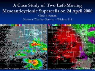
A Case Study of Two Left-Moving Mesoanticyclonic Supercells on 24 April 2006Chris BowmanNational Weather Service – Wichita, KS
The Situation… • Synoptic environment favored supercells. • Tornado Watch 244 already issued. • As the event is unfolding, storms are not taking on classic supercell characteristics. • Two cells and especially one in particular begin to exhibit unusual radar signatures.
KICT Reflectivity and SRM 0.5° Evolution 21:38Z – 22:13Z Animation
KICT Reflectivity and SRM All-Tilts 22:13Z 0.5° -19.5° Animation
KVNX Reflectivity and SRM 0.5° Evolution 21:37Z – 22:11Z Animation
KVNX Reflectivity and SRM 0.5° Evolution 22:16Z – 22:35Z Animation
KICT and KVNX SummaryObserved Items of Interest • Boundary interaction or cell merger (BICM). • Rapid strengthening of storm after BICM. • Persistent and strengthening low-level (0.5°) rotation. • KICT indicates cyclonic (≈1,000 ft), KVNX indicates anticyclonic (≈4,750 ft). • KICT indicates a transition from low-level cyclonic rotation (≈900 – 2,700 ft) to a convergent signature (≈3,000 – 10,000 ft) to a mesoanticyclone (≈12,000 ft – 25,000 ft).
What’s the decision?Tornado? Severe? No warning? • You’re in the warning chair under a tornado watch. • Storms have not exhibited typical supercell characteristics. • A storm develops rapidly with strengthening cyclonic rotation corroborated by another radar. • Storm appears to be supercellular but opposite of what was anticipated. • The storm is moving into the Wichita Metro.
What Actually Happened • Tornado warning issued at 22:15Z for SW Sedgwick and NW Sumner Counties but polygon kept Wichita out of the warning. • Two off-duty NWS mets as well as private mets observe a wall cloud with the storm. Only live report came from an off-duty NWS met as the storm and “ill-defined wall cloud” moved over his house. • No tornado was reported but several severe hail reports were received. • The storm, as viewed from KVNX, maintained its supercellular characteristics as it moved over Wichita, producing only hail reports.
KICT and KVNX SummaryThe Unexplained • Although the environment favored left-moving, mesoanticyclonic storms (more on this later), there is no clear explanation for KICT’s vertical SRM transition from low-level cyclonic rotation to mid/upper-level anticyclonic rotation • The low-level velocity signature from both KICT and KVNX are ≈3 miles north-northeast of the reflectivity signature. • Reflectivity aloft is almost on top of low-level SRM signature. • Possibly a boundary being ingested and stretched or even thunderstorm outflow.
Storm #2 • Actually occurred before the tornado warned storm. • Exhibited similar characteristics (including velocity signature ≈3 miles north-northeast of reflectivity signature) but only observed from KVNX. • Storm not as persistent and not as strong.
KVNX Storm #2 0.5° Reflectivity and SRM 21:27Z – 21:51Z Animation
Storms #1 and #2 Summary • Two storms in the same county within several volume scans of each other both develop low-level anticyclonic rotation displaced by about 3 miles to the north of the reflectivity signature. • Both have a boundary interaction or cell merger and strengthen rapidly afterward. • Both storms are in the same environment and this is the key.
Parameters derived from surface T/Td of 76/66. Near storm environment was actually ≈ 74/64. Not a huge difference right? In this case it actually makes a big difference. Need to modify sounding as a result. Environmental Data
Modified sounding drops CAPE from 2,038 J/Kg to 1,324 J/Kg. Increases CIN from -10 J/Kg to -68 J/Kg. Results in an environment that is elevated. As a result, a modified hodograph needs to be used. Environmental Data
Environmental Data • Unmodified hodograph with derived parameters. • V(obs) SRH values are positive. • Storm motion = 255 @ 21 kts.
Environmental Data • Modified hodograph with derived parameters using an elevated depth of 1 km and actual storm motion of 200 @ 29 kts. • V(obs) SRH values have become negative.
Case Summary • Two storms occurred in the same county and within several volume scans of each other that exhibited unusual radar characteristics including: • Persistent and strengthening low-level (0.5°) rotation. Cycolnic with KICT and anticyclonic with KVNX. • The rotation (from KICT and KVNX) is displaced ≈3 miles north-northeast of reflectivity. • KICT indicates a transition from low-level cyclonic rotation to a mid/upper-level mesoanticyclone.
Case Summary • Model data indicated a surface based environment when the near storm environment was actually elevated. • Model forecast storm motion was not correct. • Modified hodograph, taking into account the elevated nature and actual storm motion, reveals an environment favorable for left-moving, mesoanticyclonic supercells.
Acknowledgements • Matt Bunkers, SOO, WFO Rapid City For his help and expert opinions as well as his hodograph spreadsheet. • Ken Cook, SOO, WFO Wichita