Download
1 / 33
330 likes | 553 Vues
The International Hydrological Programme (IHP). Internationally Shared Aquifer Resources Management (ISARM) – Africa West and Southern Africa experiences by Alexandros Makarigakis, Abou Amani and Alice Aureli. Launching ISARM. In June 2000, the Intergovernmental Council of UNESCO’s IHP

E N D
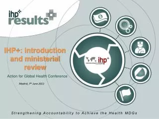
The International Hydrological Programme (IHP) Internationally Shared Aquifer Resources Management (ISARM) – Africa West and Southern Africa experiences by Alexandros Makarigakis, Abou Amani and Alice Aureli Dr. Alexandros Makarigakis
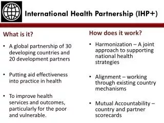
Launching ISARM In June 2000, the Intergovernmental Council of UNESCO’s IHP • Recognized that transboundary aquifer systems are important sources of fresh water in some regions of the world, • Decided to adopt a resolution to promote studies in regard to internationally shared aquifers Dr. Alexandros Makarigakis
ISARM :Multidisciplinary aspects • Legal • eg Treaties, interstate agreements • Scientific • Hydrology, hydrogeology, conceptual modelling • Socio-economic • Water security, accesibility, efficiency, poverty reduction • Institutional Capacity Building • Awareness raising, counterpart agencies • Environmental • Sustainability, biodiversity, risks, vulnerability Dr. Alexandros Makarigakis
ISARM Portal: www.isarm.net Dr. Alexandros Makarigakis
Groundwater Map of the World Dr. Alexandros Makarigakis
ISARM AFRICA • In June 2002, UNESCO along with FAO, IAEA, IAH, UNECE, SADC, OSS and OACT organized the International workshop on "Managing Shared Aquifer Resources in Africa". (hosted and supported by the General Water Authority of the Libyan Arab Jamahiriya). • During the workshop, nineteen transboundary aquifers were identified in the SADC region and forty overall on the Continent • A recommendation to finalize the inventory and assist for a sustainable management of the TBA was made Dr. Alexandros Makarigakis
USA “Lower 48” India Argentina Europe China 9,596,960 km2 USA 9,363,071 India 3,287,590 Europe 4,936,973 Argentina 2,766,890 New Zealand 268,680 TOTAL : 30,220,164 km2 Area of Africa: 30,318,830 km2 Source: World Factbook, 2004 New Zealand China The Size of Africa Dr. Alexandros Makarigakis
ISARM Africa Dr. Alexandros Makarigakis
2002 2025 Water security Adequate water Water stress Chronic scarcity Absolute scarcity N N 0 500 1000 0 500 1000 Kilometres Kilometres Water Available per Person in 2002 and 2025 Dr. Alexandros Makarigakis
Most disputes over water occur in areas of transition from perennial to ephemeral systems, or where water supplies are uncertain N 0 500 1000 Kilometres Sites of Disputes Linked to Water Dr. Alexandros Makarigakis
High Severe Many Potential consequences of a dispute Potential for dispute to occur Alternative options available for dispute resolution Low Few Mild Local National Regional Geographical scale The Importance of Scale Dr. Alexandros Makarigakis
ISARM SADC • In the local context (SADC) • What do we have? • Legislation that covers groundwater (Protocol on Shared Watercourse Systems in the SADC) • Commissions for Internationally Shared Water Resources (ORASECOM, OKAKOM, ZAMCOM etc) • Variability of available data (quantity and quality) within countries • Poverty hitting harder the rural population • Climate variability • Need for improved Socio Ecological sustainability Dr. Alexandros Makarigakis
ISARM SADC • What do we need? • Groundwater issues visible at the established Commissions for Internationally Shared Water Resources (ORASECOM, OKAKOM, ZACOM etc) • Information on groundwater resources’ quantity and quality / Standardization of available data • Communication with surface water to achieve IWRM, • Address societal needs, with transboundary issues etc Dr. Alexandros Makarigakis
ISARM SADC • Why ISARM SADC? • No other platform existing • The appropriate membership will avoid duplication and improve collaboration / complementarity; people ready to contribute • Flexibility; ability to coordinate limited time project within an agreed framework • International Organization backing scientifically • SADC involvement Dr. Alexandros Makarigakis
ISARM SADC Address the approved SADC Regional Groundwater Management Programme (1998) 3. Establishment of a Regional Groundwater Information System 4. Establishment of a Regional Groundwater Monitoring Network 5. Compilation of a Regional Hydrological Map and Atlas for the SADC Region 8. Regional Groundwater Resource Assessment of Karoo Aquifers Dr. Alexandros Makarigakis
ISARM SADC • An ISARM SADC initiative supported by UNESCO commenced in March 2007 in Pretoria RSA. The initiative intends to • Establish a network • Provide a Mechanism for Coordination • Provide a TBA Inventory • Two subsequent meetings were then held in Windhoek 2007 and Stampriet 2008 Dr. Alexandros Makarigakis
ISARM SADC The second ISARM SADC meeting took place in July 2007, in Windhoek and intended to: • Initiate the efforts of strengthening RBOs in gw • Develop a concept proposal to be submitted to ORASECOM • Exchange information on various initiatives in the area Dr. Alexandros Makarigakis
ISARM SADC • Climate variability will result in increased stress on gw resources • Latest TDA Analysis on Orange Senqu has no groundwater input • Need to feature prominately on the Commission’s plans • Opportunity for establishing relative legislation with the adoption of the UN International Law on TBA • AMCOW decision in Brazzavile • South Africa chairing AMCOW Dr. Alexandros Makarigakis
ISARM SADC Dr. Alexandros Makarigakis
Part of the Orange-Senqu Basin Dr. Alexandros Makarigakis
Transboundary Study on Hydrogeologyfor Stampriet TBA 1. Delineation of the extent of the TBA 2. Collection and collation of existing data, information and knowledge 3. Selection & Definition of study areas, Confirmation of aquifer types 4. Establishment of hydrogeological Sub-Regions 5. Demarcation of recharge & discharge areas and flow dynamics/ Potential of artificial recharge 6. Development of a conceptual model (TBA boundary conditions, various scenarios, water balance, protection zoning, abstraction limits etc) Dr. Alexandros Makarigakis
Socio-Economic Proposed Transboundary Study for Stampriet TBA 1. Land Use & Land Degradation : current and future impacts 2. Water Use/ Water Management Plan (e.g. Irrigation Efficiency, Well Head Protection, Drought Vulnerability, Abstraction Limits) 3. Water Quality (e.g. Nitrates, Salinity, Vulnerability) 4. Community monitoring of groundwater (Awareness of groundwater/ Basin Management Committees) 5. Contribution of groundwater to the economic value of an area/ GW-Dependent Ecosystems Dr. Alexandros Makarigakis
Socio-Economic Proposed Transboundary Study for Stampriet TBA 6. Legal and regulatory framework 7. Work in a full catchment holistic approach 8. Poverty/ Groundwater’s contribution: Access to water, Food security 9. Environmental Protection 10. Links to IWRM plans and process Dr. Alexandros Makarigakis
The picture before On SIG Afrique/Africa GIS background Dr. Alexandros Makarigakis
ISARM SADCPart of the picture after Dr. Alexandros Makarigakis
Part of the Orange-Senqu Basin Dr. Alexandros Makarigakis
Could this be the case of Stampriet? Dr. Alexandros Makarigakis
ISARM West Africa Objectives: Status of data and information available: • Gap Analysis and improvement of the inventory • To Identify mechanism for cooperation and the finalization of the data collection; • To Identify the main products for ISARM West Africa and a timetable of actions • To identify case studies Dr. Alexandros Makarigakis
ISARM West Africa • Nine potential transboundary hydrogeo-systems considered: • Iullimeden • Senegalo-mauritania • Lake Chad • Taoudeni • Basin of Tano • Basin of Keita • Volta • Djado-Mourzouk • Bilma-Agadem Dr. Alexandros Makarigakis
ISARM West Africa • Gap Analysis for each potential system • Transboundary nature of different aquifers; • Monitoring status (quantity and quality) • Availability of database systems; • Level of pressure on the aquifers (pollution, over-exploitation,.); • modelling Dr. Alexandros Makarigakis
ISARM West Africa • Action plan for the preparation of Atlas on West Africa TBA • Data collection and analysis at national level for each TBA system; • For each TBA system concertations between the national focal points; • A team leader proposed for each system to coordinate activities; • Validation of the Atlas at sub-regional level Dr. Alexandros Makarigakis
ISARM West Africa • ISARM ongoing in West Africa • Gap analysis made on the prelimenary data and information collected; • transboundary nature of many aquifers needs to be precised or documented ; • Action plan for TBA Atlas in West Africa for the next two years; • Partnership Dr. Alexandros Makarigakis
…It has to start somewhere It has to start sometime What better place than here What better time than now … RATM THANK U 4 UR @ENTION ΕΥΧΑΡΙΣΤΩ Dr. Alexandros Makarigakis