Download
1 / 12
140 likes | 154 Vues
Develop an algorithm using lightning jumps for forecasting severe weather. Statistical tests, GLM vs. LMA sources, and impact of storm anomalies on detection efficiency explored. Importance of ice water path, flash height, and flash size in detection efficiency.

E N D
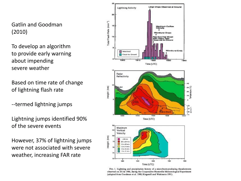
Gatlin and Goodman (2010) To develop an algorithm to provide early warning about impending severe weather Based on time rate of change of lightning flash rate --termed lightning jumps Lightning jumps identified 90% of the severe events However, 37% of lightning jumps were not associated with severe weather, increasing FAR rate
Main statistical tests The lightning jump occurs when the FR exceeds the running average FR (6-10 min period) plus twice the standard deviation of FR. Running average computed from 6-10 min period of 1 min FR data or 12-20 min when using 2 min FR data
Basic premise is that increases in lightning flash rate is tied to updraft intensification… Why should this be the case? What about supercellular vs. non-supercellular storms in terms of lightning jump timing and occurrence of tornadoes (landspouts)?
GLM was developed to help with “nowcasting” severe weather… Is GLM up to the task???
LMA sources are concentrated near 6 km throughout the duration of the analysis period; we identify this as a “anomalous” storm, with enhanced low level positive charge • Greeley anomalous storm is very intense, displaying multiple regions of 65 dBZ extending to 8 km agl
Greeley Anomalous Polarity Storm • GLM produces fewer flashes with little variance in flash rate compared to LMA, the latter showing a factor of 2 variation in FR • GLM/LMA ratio (~detection efficiency) averages near 0.1 • Largest DE occurs when the LMA FR is a minimum • GLM events and groups are roughly the same magnitude as LMA flash rates • GLM events and groups show a gradual increase in minute by minute counts, but GLM flashes do not
median flash area; median flash altitude • Relative maxima in DE coincide with peaks in LMA-derived median flash size • The DE “tracks” with flash area (flash size); DE decreases as median flash area decreases even though the median flash height increases; however these median flash heights are still fairly low, characteristic of anomalous storms (we will see later that flash heights are substantially greater in normal polarity storms which appears to impact DE)
Kind of the crux of the matter…ice water path, flash height and flash size all matter to impact detection efficiency
LIS_LMA comparison