1 / 51

Jeopardy

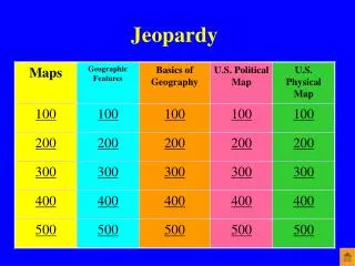
Jeopardy. This type of map shows the borders between countries and states. What is a political map. This map tool shows direction. What is a compass rose. This type of map shows elevation using lines. What is a contour or topographic map. This map tool helps measure distance.

brad
Télécharger la présentation

Jeopardy

An Image/Link below is provided (as is) to download presentation Download Policy: Content on the Website is provided to you AS IS for your information and personal use and may not be sold / licensed / shared on other websites without getting consent from its author. Content is provided to you AS IS for your information and personal use only. Download presentation by click this link. While downloading, if for some reason you are not able to download a presentation, the publisher may have deleted the file from their server. During download, if you can't get a presentation, the file might be deleted by the publisher.

E N D

Presentation Transcript


  1. Jeopardy

  2. This type of map shows the borders between countries and states.

  3. What is a political map.

  4. This map tool shows direction.

  5. What is a compass rose.

  6. This type of map shows elevation using lines.

  7. What is a contour or topographic map.

  8. This map tool helps measure distance.

  9. What is a scale.

  10. This type of map displays information like religion, population density, and temperature.

  11. What is a special purpose or thematic map.

  12. This is a piece of land that is surrounded by water on three sides.

  13. What is a peninsula.

  14. This is a river or stream that feeds into a larger river.

  15. What is a tributary.

  16. This is flat, low-lying land built up from soil carried downstream by a river and deposited at its mouth.

  17. What is a delta.

  18. A mountain created as liquid rock or ash erupts from inside the earth is called this.

  19. What is a volcano.

  20. This is a narrow stretch of land connecting two larger land masses.

  21. What is an isthmus.

  22. Imaginary lines that run north to south and divide the earth into eastern and western hemispheres are called this.

  23. What are lines of longitude or meridians.

  24. This tool is the most accurate way to depict the earth and is the #1 tool of geographers.

  25. What is a globe.

  26. These imaginary lines run east to west and divide the earth into northern and southern hemispheres.

  27. What are lines of latitude or parallels.

  28. These are the 2 imaginary lines that divide the earth into hemispheres.

  29. What are the equator and Prime Meridian.

  30. These are the 5 themes of geography.

  31. What is place, location, region, movement, and human/environment interaction.

  32. This state borders Illinois to the north.

  33. What is Wisconsin.

  34. This state borders New Hampshire to the west.

  35. What is Vermont.

  36. This state borders South Dakota to the south.

  37. What is Nebraska.

  38. This state borders Arizona to the east.

  39. What is New Mexico.

  40. This state consists of 2 peninsulas.

  41. What is Michigan.

  42. These are the 5 Great Lakes.

  43. What are Lake Erie, Lake Ontario, Lake Huron, Lake Michigan, and Lake Superior.

  44. This is the lowest point in the United States.

  45. What is Death Valley.

  46. The Everglades are found in this state.

  47. What is Florida.

  48. This mountain range is on the border of California and Nevada.

  49. What are the Sierra Nevada Mountains.

  50. The Missouri and Ohio rivers are tributaries to this river.

More Related