Himalayas: A Collision of Plates and Earthquake Patterns
Explore the formation of the Himalayas, the collision of the Indian and Eurasian plates, earthquake occurrences, and the impact of seismic activities in the region.


Himalayas: A Collision of Plates and Earthquake Patterns
E N D
Presentation Transcript
Himalayas Niall, Vineet, Delvin
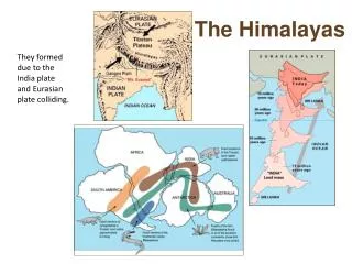
Introduction • Himalayas formed around 20-40 million years ago. Prior to the Eurasian and Indo-Australian plate colliding they were separated by the Tethys Sea. When the Indo-Australian plate collided with the Eurasian plate, the light sediments from the seabed were forced up, forming the Himalayan mountain range. • Every 100 years India moves 200 cm north against the Asian plate. This colliding force builds up pressure continually for several years and this pressure is released in the form of earthquakes from time to time.
In this case: The Indian Plate is colliding head-on with the Eurasian Plate. Both plates are comprised of continental lithospheric crust, so there is no appreciable distinction in density. Both have a density of approximately 2.7 g/cm³. This as opposed to ocean crust with a mean density of 3.3 g/cm³. The plates try to compete in the plate-to-plate collision but the equal densities of the two plates cannot push one under the other very deep like that in a subduction zone. The result is large-scale thickening of the continental crust in the region at and surrounding the collision boundary. There are tremendous temperatures attained at a continental plate-to-plate collision boundary. However, the crust is simply too thick, and too “squashed together” to allow anything to squeeze up and break through to the surface as volcanic eruptions. • Collision Plate Boundary:
What are the processes involved? • The process begins as two continents (different bits of continental crust), separated across a tract of ocean (and oceanic crust), approach each other, while the oceanic crust is slowly consumed at a subduction zone. The subduction zone runs along the edge of one of the continents and dips under it, raising volcanic mountain chains at some distance behind it. Continental crust is subducted with difficulty, but is subducted to depths of 90-150 km or more. Normal subduction continues as long as the ocean exists, but the subduction system is disrupted as the continent carried by the down going plate enters the trench. Because it contains thick continental crust, this lithosphere is less dense than the underlying asthenospheric mantle and normal subduction is disrupted. The volcanic arc on the upper plate is slowly extinguished. Resisting subduction, the crust buckles up and under, raising mountains where a trench used to be.
What patterns of hazards are produced? • Four major earthquakes have occurred in the Himalayan region in the past 100 years. The famous earthquake that hit Nepal in 1933 A.D. killed thousands of people in Nepal and northern India. Several earthquakes have occurred since that time.
The Indian Himalayas have experienced some significantly strong earthquakes in the last few decades. • Kinnaur Earthquake (1975) • This earthquake struck in the early afternoon of January 19, 1975. It caused havoc in parts of the Kinnaur, Lahaul and Spiti regions of India. It is believed to have been caused by movements along a fault known as the Kaurik fault. This quake killed hundreds of people and caused severe damage to property. A massive landslide was triggered off by this earthquake near Maling in the Spiti Valley. Another giant landslide blocked the Parochu River near Sumdo. Many smaller occurrences of slope failure were caused by this earthquake. As a result, communications remained disrupted for several days and helicopter services had to be pressed into operation to bring relief to the worst-affected areas. • Uttarkashi Earthquake (1991) • In the early morning hours of October 14, 1991, a severe earthquake shook Uttarkashi and Chamoli districts of Garhwal. It caused widespread loss of life and property. This earthquake also affected other parts of Garhwal and Kinnaur. The regions remained cut off from the rest of the world for several days due to the debris. Landslides occurred at several locations, and it took a significant amount of time for people to recover from this incident. From this data, not only do we see a pattern that only Earthquakes can and have occurred at this plate boundary, but there are patterns within the impacts. The same secondary impacts arise such as landslide and property damage. The time period between each Earthquake is very hard to predict as it ranges from every 5-20 years there is an Earthquake.
Until recently it was believed that four magnitude 8 earthquakes had occurred in the past 100 years. The first of these events (1897) is now known not to have occurred in the Himalaya but beneath Shillong, the second (1905) has been recalculated to have been smaller (M=7.8) and were it to recur today would do so in a M=7.5 earthquake. • The number of great earthquakes known in the past several centuries appears inadequate to accommodate the 16-18 mm/year of Himalayan convergence observed. • We conclude that several M>8 earthquakes may be overdue. Due to increased populations and urbanization in the Ganges plain, the death toll from any one of these earthquakes could now exceed 1 million.
What Impacts have there been? • One of the biggest impacts of earthquakes in the Himalayan regions is deaths. It has recently been reported, that an estimated 800,000-900,000 people could die if an earthquake of magnitude 8+ occurs. This is because the areas near the Himalayas are extremely populous (Northern India, Pakistan and Nepal).
2005 Kashmir Earthquake: • 8th October. • Magnitude 7.6 • Focus: 26 km deep. Epicentre: 100 km north of Islamabad. • 100,000 deaths (18th most of any earthquake). • 138,000 injured 3.5 million homeless. • $6-7 billion in damage. • Over $5.4 billion in aid. • US Army and RAF deployed to assist. • 5 Crossing points opened between India and Pakistan to allow humanitarian and medical aid into the most affected regions.
2001 Gujarat Earthquake: • January 26th. • 7.7 magnitude • 20,000 deaths (largest affected areas were only villages!) • 167,000 injured. 400,000 homes destroyed (40% of all homes). • 60% of food and water stocks destroyed. • $5.5 billion in damage • 8 schools and 2 major hospitals destroyed. • Red Cross, opened up a medical facility due to the destruction of the hospitals. • Indian Military brought in to find survivors and organise a clean up.