Download
1 / 1
10 likes | 139 Vues
Universidade de São Paulo – School of Engineering Computing and Digital Systems Engineering Dept. Agricultural Automation Laboratory (LAA). A GEOREFERENCING TOOL TO IMPROVE BIODIVERSITY DATA QUALITY. VEIGA, A. K.; SARAIVA, A.M.; CARTOLANO-JÚNIOR, E. A.

E N D
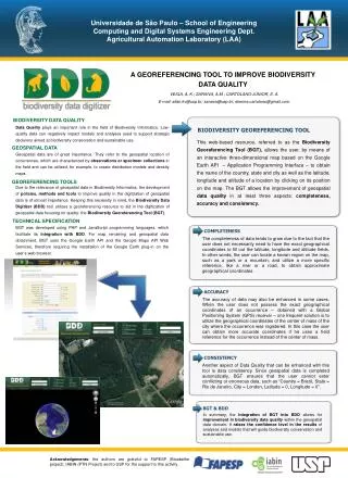
Universidade de São Paulo – School of Engineering Computing and Digital Systems Engineering Dept. Agricultural Automation Laboratory (LAA) A GEOREFERENCING TOOL TO IMPROVE BIODIVERSITY DATA QUALITY VEIGA, A. K.; SARAIVA, A.M.; CARTOLANO-JÚNIOR, E. A. E-mail: allan.kv@usp.br; saraiva@usp.br; etienne.cartolano@gmail.com. BIODIVERSITY DATA QUALITY Data Quality plays an important role in the field of Biodiversity Informatics. Low-quality data can negatively impact models and analyses used to support strategic decisions aimed at biodiversity conservation and sustainable use. BIODIVERSITY GEOREFERENCING TOOL This web-based resource, referred to as the Biodiversity Georeferencing Tool (BGT), allows the user, by means of an interactive three-dimensional map based on the Google Earth API – Application Programming Interface – to obtain the name of the country, state and city as well as the latitude, longitude and altitude of a location by clicking on its position on the map. The BGT allows the improvement of geospatial data quality in at least three aspects: completeness, accuracy and consistency. GEOSPATIAL DATA Geospatial data are of great importance. They refer to the geospatial location of occurrences, which are characterized by observations or specimen collections in the field and can be utilized, for example, to create distribution models and density maps. GEOREFERENCING TOOLS Due to the relevance of geospatial data in Biodiversity Informatics, the development of policies, methods and tools to improve quality in the digitization of geospatial data is of utmost importance. Keeping this necessity in mind, the Biodiversity Data Digitizer (BDD) tool utilizes a georeferencing resource to aid in the digitization of geospatial data focusing on quality: the Biodiversity Georeferencing Tool (BGT). TECHNICAL SPECIFICATION BGT was developed using PHP and JavaScript programming languages, which facilitate its integration with BDD. For map rendering and geospatial data obtainment, BGT uses the Google Earth API and the Google Maps API Web Services, therefore requiring the installation of the Google Earth plug-in on the user’s web browser. COMPLETENESS The completeness of data tends to grow due to the fact that the user does not necessarily need to have the exact geographical coordinates to fill out the latitude, longitude and altitude fields. In other words, the user can locate a known region on the map, such as a park or a mountain, and utilize a more specific reference, like a river or a road, to obtain approximate geographical coordinates. ACCURACY The accuracy of data may also be enhanced in some cases. When the user does not possess the exact geographical coordinates of an occurrence – obtained with a Global Positioning System (GPS) receiver – one frequent solution is to utilize the geographical coordinates of the center of mass of the city where the occurrence was registered. In this case the user can obtain more accurate coordinates if he uses a field reference for the occurrence instead of the center of mass. CONSISTENCY Another aspect of Data Quality that can be enhanced with this tool is data consistency. Since geospatial data is completed automatically, BGT ensures that the user cannot enter conflicting or erroneous data, such as “Country = Brezil, State = Rio de Janeiro, City = London, Latitude = 0, Longitude = 0”. BGT & BDD In summary, the integration of BGT into BDD allows for improvement in biodiversity data quality within the geospatial data domain. It raises the confidence level in the results of analyses and models that will guide biodiversity conservation and sustainable use. Acknowledgements: the authors are grateful to FAPESP (Bioabelhe project), IABIN (PTN Project) and to USP for the support to this activity.