Workshops:
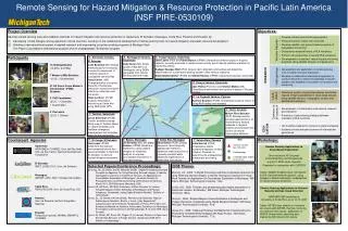
Remote Sensing for Hazard Mitigation & Resource Protection in Pacific Latin America (NSF PIRE-0530109). Project Overview Develop remote sensing tools and validation methods for hazard mitigation and resource protection in Guatemala, El Salvador, Nicaragua, Costa Rica, Panama and Ecuador by:

Workshops:
E N D
Presentation Transcript
Remote Sensing for Hazard Mitigation & Resource Protection in Pacific Latin America (NSF PIRE-0530109) • Project Overview • Develop remote sensing tools and validation methods for hazard mitigation and resource protection in Guatemala, El Salvador, Nicaragua, Costa Rica, Panama and Ecuador by: • (1) Developing formal linkages among agencies in those countries, focusing on the collaborative development of remote sensing tools for hazard mitigation and water resource development. • Building a new educational system of applied research and engineering using two existing programs at Michigan Tech: • The Peace Corp Master’s International program and an undergraduate “Enterprise” program. Objectives: • Develop volcanic gas monitoring programs • Forecast activity of open vent volcanoes • Develop satellite- and ground-based programs of topographic monitoring • Characterize eruptive history of PLA volcanoes • Perform risk assessment of several PLA volcanoes • Development of sustained natural hazard monitoring programs using satellite imagery and geophysics • Development and application of remote sensing tools for water resource exploration • Develop a collaborative international approach to conduct research to improve knowledge of aquifer systems and establish a foundation for research and monitoring • Determine location of past slope failures and define regions of high susceptibility to future slope failures using satellite sensors , topographic studies, and geotechnical analyses • Development of collaborative international research and education • Promotion of data-sharing dialogue between members of PLA countries • US students prepared for careers in global workplace • Students choose education/careers in international geoscience Volcanic Hazards Participants 13 Undergraduates (10 MTU, 3 UPRM) 7 Master’s (MS) Students (6 US, 1 Guatemalan) 21 US Peace Corps Master’s International (PCMI) Students 5 PhD Candidates (3 US, 1 Colombian, 1 Guatemalan) 3 Post-docs (2 US, 1 Chilean) Santa Ana Volcano, El Salvador Luke Bowman (MS) Design methodology for increasing community awareness of volcanic hazards in susceptible communities. Anna Colvin (MS) Characterization of eruption hazards of Santa Ana; precursors and post-eruption effects on crater lake and fumaroles. Hans Lechner (PCMI) Surface deformation monitoring at Santa Ana using differential GPS. Santiaguito Volcano, Guatemala Kelly Durst (MS) Dome growth (1954-2001) of Santiaguito using DEMs generated from remote sensing data and maps. Fuego Volcano, Guatemala John Lyons (PhD) and Karen Bunce (UPRM)Characterize different styles of eruptive behavior currently produced to model current activity and to identify effective methods for monitoring activity. Rudiger Escober-Wolf (PhD) Assess risk to affected communities and determine effectiveness of current early warning system under various scenarios. Adam Blankenbicker (PCMI) and Edrick Ramos (UPRM) Characterize plumes using video records of eruptive events. RESEARCH Hydrogeology Land- slides Pacaya Volcano, Guatemala Jose Palma (Post-doc) and Otoniel Matias (MS) Characterize deformation and gravity changes at Pacaya volcano. Common to all research La Yeguada Volcano, Panama Karinne Knutsen (PCMI) Characterize eruptive history of using Ar/Ar dating and mapping. Quito, Ecuador Miriam Rios-Sanchez (PhD) Develop remote-sensing based protocol for characterizing fracture networks in regional systems and evaluate their control on natural hydrological behavior. EDU- CATION Tectitán, Guatemala Jesse Silverman (PCMI) Create landslide suscep-tibility map of Tectitan based on recent landslides and facilitate emergencymanagement and mitigation plans for the community. Counterpart Agencies Workshops: Guatemala INSIVUMEH, CONRED, Univ. del San Valle, Univ. de San Carlos, German Development Cooperation El Salvador SNET, LAGEO S.A., Univ. del Salvador Nicaragua INETER, CIRA, SNV, Omotepe field station Costa Rica RSN,OVISCORI, Univ. de Costa Rica, ICE Panama Univ. de Panama, InstitutoGeograficoNacional Ecuador Politecnicanacional, INHAMI, EMAAP-Q, CLIRSEN Remote Sensing Applications to Groundwater Exploration Short-course at XI Congreso Latinoamericano de Hidrogeologia July 8-12, 2008, Quito, Ecuador Presented in conjunction with CLIRSEN Topics: Satellite Imagery types, introduction to GIS, fractured bedrock aquifers, using imagery to detect lineaments, fundamentals of natural resource protection Remote Sensing Applications to Volcanic Hazards and Gas Cloud Detection MARGINS NSF workshop at University of Costa Rica, June 14-15, 2007 Topics: ASTER data, detection of volcanic ash clouds with AVHRR, thermal monitoring of volcanoes from space , application of MODIS infrared data, observing and measuring SO2 clouds from space Key Volcanic hazard/ gas emissions Hydrogeology Landslide/slope stability assessment El Congo, El Salvador York Lewis (PCMI) Determine the regional environmental factors that cause landslides in Northern El Salvador to improve hazard mitigation programs. Boaco, Nicaragua Jill Bruning (MS) and Carla Alonso (UPRM) Develop a method for using satellite imagery for lineament analysis to improve groundwater exploration in non-ideal settings. Santa Rita, Nicaragua Essa Gross (PCMI) Design economic, technologically appropriate method to determine well productivity in manually pumped wells; determine significance of water table fluctuations. Volcan Baru, Panama Julie Herrick (PCMI) Characterize debris avalanche deposits on Baru Volcano, Panama, to determine the emplacement mechanism and timing. Selected Papers/Conference Proceedings: Bruning, JN, JS Gierke, and AL Maclean (2009). “Digital Processing and Data Compilation Approach for Using Remotely Sensed Imagery to Identify Geological Lineaments in Hard-Rock Terrains: An Application for Groundwater Exploration in Nicaragua,” American Society for Photogrammetry and Remote Sensing, 2009 Annual Conference, March 9-13, 2009 Baltimore, Maryland, USA. Durst, KS, WI Rose, RE Wolf, A Maclean, M Rios-Sanchez (in review). “Erupted Magma Volume Estimates at Santiaguito and Pacaya Volcanoes, Guatemala, Using Digital Elevation Models,”Bulletin of Volcanology. Gross, EL, JS Gierke, A Kome (2008). “Monitoreo de RecursosHidricosSubterraneosSencillos, Barato, y Local, ¿Hay Esperanza?; Caracterizacion de los EfectosTemporales en PozosPerforados con Bombas de Mecate en AcuiferosFracturadosBasalticos en Nicaragua,” XI CongresoLatinoamericano de Hidrogeologia, 8-12 Julio 2008, Quito, Ecuador. Lyons, JJ, Waite, GP, Rose, WI, Chigna, G, (in review) Patterns in Open vent, Strombolian Behavior at Fuego Volcano, Guatemala 2005-2007, Bulletin of Volcanology . 2008 Theses: Bruning, J.N., 2008, “A Digital Processing and Data Compilation Approach for using Remotely Sensed Imagery to Identify Geological Lineaments in Hard Rock Terrains: An Application for Groundwater Exploration in Nicaragua,“ MS thesis, Michigan Technological University, 144p. Colvin, A.S., 2008, “Phreatic and phreatomagmatic hazard assessment of Santa Ana volcano, El Salvador,” MS thesis, Michigan Technological University, 188 p. Durst, K., 2008, “Erupted Magma Volume Estimates at Santiaguito and Pacaya Volcanoes, Guatemala using Digital Elevation Models,” MS thesis, Michigan Technological University, 40 p. Gross, E.L., 2008, “A Manual Pumping Test Method for Characterizing the Productivity of Drilled Wells Equipped with Rope Pumps ,” MS thesis, Michigan Technological University, 77 p.