
Uploaded by
caesar
3 SLIDES
178 VUES
30LIKES
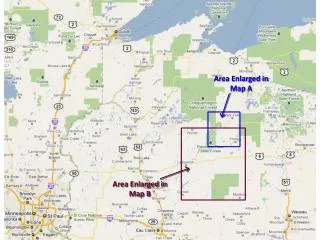
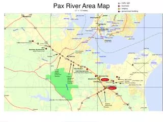
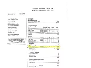
Overview of Tornadic and Non-Tornadic Wind Damage Areas in Maps A and B
DESCRIPTION
This document explores the wind damage locations depicted in Maps A and B, highlighting areas affected by weak EF-1 tornadoes and brief EF-0 tornado occurrences. Non-tornadic wind damage is identified and denoted by blue arrows for clear visualization. The maps serve to convey the distribution of these weather events and their impact on the landscape. Detailed analysis also includes discussions on wind speed, damage assessments, and important safety advisories related to these weather patterns.
Download
1 / 3
Télécharger la présentation 
Overview of Tornadic and Non-Tornadic Wind Damage Areas in Maps A and B
An Image/Link below is provided (as is) to download presentation
Download Policy: Content on the Website is provided to you AS IS for your information and personal use and may not be sold / licensed / shared on other websites without getting consent from its author.
Content is provided to you AS IS for your information and personal use only.
Download presentation by click this link.
While downloading, if for some reason you are not able to download a presentation, the publisher may have deleted the file from their server.
During download, if you can't get a presentation, the file might be deleted by the publisher.
E N D
Presentation Transcript
Area Enlarged in Map A Area Enlarged in Map B
Non-tornadic wind damage locations denoted by blue arrows Weak EF-1 Tornado
Brief EF-0 Tornadoes Non-tornadic wind damage locations denoted by blue arrows


More Related