Download
1 / 84
850 likes | 1.06k Vues
2008 GOES-R Annual Review Agenda Wed-Thu, September 3-4, 2008, Room 2001 NSOF, Suitland Maryland (All Times are Eastern Time) Call in Number: 888-390-7303, passcode: 16221 Master presentation files available from: ftp://rammftp.cira.colostate.edu/demaria/goesr08-review/Final

E N D
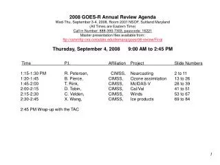
2008 GOES-R Annual Review Agenda Wed-Thu, September 3-4, 2008, Room 2001 NSOF, Suitland Maryland (All Times are Eastern Time) Call in Number: 888-390-7303, passcode: 16221 Master presentation files available from: ftp://rammftp.cira.colostate.edu/demaria/goesr08-review/Final Thursday, September 4, 2008 9:00 AM to 2:45 PM Time P.I. Affiliation Project Slide Numbers 1:15-1:30 PM R. Petersen, CIMSS, Nearcasting 2 to 11 1:30-1:45 B. Pierce, CIMSS, Ozone assimilation 13 to 26 1:45-2:00 T. Rink, CIMSS, McIDAS-V 28 to 39 2:00-2:15 D. Tobin, CIMSS, Cal/Val 41 to 51 2:15-2:30 C. Velden, CIMSS, Winds 53 to 67 2:30-2:45 X. Wang, CIMSS, Ice products 69 to 84 2:45 PM Wrap-up with the TAC
1. FY09 GOES-R3 Project Proposal Title Page • Title: Nearcasts - Filling the gap between Observations and NWP using Dynamic Projections of GOES Moisture Products • Project Type: GOES Utilization Proposal – Application of GOES-R ABI • Status: Ongoing – Preparing for NWS Field evaluation • Duration: Reporting on 1st year of 3 year proposals • Leads: • Ralph Petersen (CIMSS), Bob Aune (NESDIS) • Other Participants: • NWS forecast offices, NWS Regional SSDs, NCEP AWC • Nearcasts – • Increasing the use of GOES data • -Filling the 4-5 hr information gap • between • Extrapolation based Nowcasts • (using primarily Radar Data) • and • NWP based Forecasts Filling the Gap 0-1 hr 6 hrs and beyond
2. Project Summary – Fundamentally unchanged from 2007 Review • The overall goal of this project is to provide forecasters with new tools to help identify areas where convection is and is not likely 3-6 hours in advance of storm development using moisture and temperature products from future GOES satellites. • Due to the perishability of the information, NearCasts requires numerical approaches that are extremely fast and notably different from those used in numerical weather prediction covering longer time periods. • The new Lagrangian approach to objective NearCasting optimizes the impact and retention of information provided by GOES satellites. • Designed to ingest and preserve extreme vertical and horizontal variations of moisture/temperature observed and updated by GOES • GOES data not currently used in NWP over land • Extremes are under-represented in conventional NWP analyses and forecasts. • Initial NearCasting products include 1-6 hour projections of the GOES multi-layer moisture observations, along with predictions of derived areas of convective destabilization. • Existing GOES sounder DPI products used as surrogate for GOES-R ABI • Discussions begun to test system using MeteoSat data • Being expanded to include other stability indices • Methodology directly transferable to GOES-R • Higher spatial/temporal resolution of ABI products will improve products further.
3. Motivation/Justification – Fundamentally unchanged from 2007 Review • Supports NOAA Mission Goals: Weather and Water, Commerce & Transportation, Homeland Security, Geostationary Orbiting Environmental Satellite Acquisitions • The Nearcasting System adds a short-range forecast component to GOES observations. • An area highlighted in the GOES-R3 program plan • According to the most recent version of the GOES-RRR Plan, Nowcasting applications developments (including the time-range of this project) was included throughout the life of the GOES-RRR program. • Although GOES multi-level DPI moisture observations have been shown to improve upon model first guesses and provide mesoscale detail not available from any other observing system, the data are not used over land in operational numerical forecast system. • As such, previous and ongoing investments in GOES satellites are being underutilized. • Uses the GOES moisture/temperature data at full resolution • The methodology used here is directly transferable to GOES-R ABI products • Although the value of GOES observations is eliminated after cloud formation occurs, the Nearcast System anticipates destabilization by dynamically projecting GOES multi-level products to future locations, independent of subsequent cloud development. • Provides evidence of need to support Geostationary Orbiting Environmental Satellite Acquisitions • The hourly-updated Nearcast output should help forecasters identify/isolate areas where severe convection is likely to occur 1-6 hours in advance. • Will reduce size of warning/watch areas, extend the lead time of watches/warnings, increase Probability of Detection and reduce False Alarms – Weather and Water and Homeland Security Goals • Especially useful for hard-to-forecast isolated summer-time convective events – Commerce and Transportation Goal (especially Aviation)
4. Methodology – Fundamentally unchanged (expanded) from 2007 Review How Lagrangian NearCasts work: An Example of “Convective Destabilization” Instead of interpolating randomly spaced moisture observations to a fixed grid (which smoothes the data) and then calculating moisture changes at the fixed grid points, the Lagrangian approach interpolated wind data to locations of GOES multi-layer moisture observations and then moves the full-resolution observed data to new locations, using the primitive equations to dynamically changing wind fields with ‘long’ (10 minute) time steps. . The moved moisture ‘obs’ values from each level are then both: 1) Transferred back to an ‘images’ for display and for use as ‘predicted DPIs’, and 2) Combined (subtracted) to identify meso-scale areas where Convective Instability will develop (where low-level moisture becomes capped by dry air aloft), even after convective clouds appear. Nearcast of Vertical Moisture Gradient (Convective Instability) (900-700 hPa GOES PW -700-500 hPa GOES PW) 3 Hour Nearcast : Valid 0000UTC 13 April 2006 – 2100 UTC 900-700 hPa GOES PW 0 Hour Ob Locations 13 April 2006 – 2100 UTC 900-700 hPa GOES PW 3 Hour Nearcast Image Verification Updated Hourly - Full-resolution 10 km data - 10 minute time steps
5. Summary of Previous Results – Expanded from 2007 Review • Efforts in previous years have used GOES-RRR Nowcasting and CIMSS resources to: • 1) In past years, • Developed and test the new Lagrangian-based dynamical Nearcasting Model, • Integrated GOES multi-layer DPI moisture data as a pre-curser for GOES-R ABI data, • 2) In current year, • Developed visualizations to depict predicted DPIs in formats identical to the observations. • This is critical for rapid assimilation of the Nearcast information during demanding forecasting situations • Efforts in current year include: indications of areas without data in past 6 hours, decreased confidence with time and revalidation as new data become available over time. • WFOs, NWS/CRH and NCEP/AWC agreed to participate in evaluations of the Nearcast products. • Validated need for this type of product and indicated areas for immediate application (especially AWC) • Evaluation sites prefer data in GRIB-II for use in AWIPS rather than as web-based imagery. • Required redirection of visualization efforts during past year to meet user requests. • Test Cases have demonstrated that: • Nearcasts expand the value of current and future GOES moisture products from observations to short-range forecasting tools • GOES DPI data can be inserted directly into model without “analysis smoothing’ • Nearcasts preserve observed data gradients, maxima and minima – image cycling maintains impact of past data • Stability information preserved as data projected into areas of subsequent cloud development • Nearcast Images agree well with lhe location and timing of storm formations and provide accurate/timely guidance, even after clouds have formed • System provides a fast, objective tool which increases the length of time that forecasters can make good use of detailed information from GOES products in their short range predictions • (vs. relying exclusively on smoother NWP output) Case of severe hail storm near Madison, WI Not predicted by operational NWP models
6. Expected Outcomes – Fundamentally unchanged from 2007 Review • If successful, WFO and NCEP Service Centers will improve their very-short-range forecasts and the GOES-R program office will have a series of examples showing how to maximize the benefit of temporal and spatial improvements available when GOES data are used effectively. 24 Hr Precip • Provide very-short-range, objective tools (NearCasts) to WFOs which will use existing DPI and future GOES-ABI products to: • Use projections of GOES multi-layer products to update NWP guidance • Identify areas of convective instability, even after cirrus outflow restricts the areas from being observed by GOES IR instruments. • Increase the length of time that forecasters can make good use of quality GOES observations which can supplement NWP guidance for their short range forecasts • Use GOES moisture/temperature products at full resolution • Preserve extreme horizontal and vertical gradients observed in GOES DPI products but missing in NWP • Improvements in spatial and temporal quality of GOES-R ABI will enhance products substantially • Hourly-updated NearCast output will help forecasters identify/isolate areas where severe convection is/is not likely to occur 1-6 hours in advance. • Products should be especially useful for hard-to-forecast isolated summer-time convective events – (especially important to Aviation operations) • Nearcasts of the pre-convective environment will allow forecasters to reduce the size of warning/watch areas, extend the lead time of watches/warnings, increase Probability of Detection and reduce False Alarms – (documented NWS Goals) • Nearcast products are scheduled to be tested initially in mid-western NWS/WFOs and AWC. • Based on positive tests and training, Nearcast Model products (and training materials) will be distributed to a broader set of NWS offices and made available to the private sector via the internet. 10 cm Hail Vertical Moisture Gradient (900-700 hPa - 700-500 hPa GOES PW) Forecast Information Lost under cirrus shield without NearCast
6. Expected Outcomes – Expanded from 2007 Review • Provide very-short-range, objective (nearcast) tools to WFOs which will use current and future GOES-ABI moisture/temperature products to: • Use projections of GOES multi-layer moisture/temperature products to update NWP guidance • Identify areas of convective potential, even after cirrus outflow restricts the areas from being observed by GOES IR instruments, using multiple Stability Parameters. • Increase the length of time that forecasters can make good use of quality observations which can supplement NWP guidance for their short range forecasts • Use GOES moisture/temperature products at full resolution • Preserve extreme horizontal and vertical gradients observed in GOES DPI products but missing in NWP Example of how forecasters will monitor, correct and locally enhance short-range NWP guidance for strong convection using projections of GOES moisture data which are available, even after the storms have begun. Nearcasts of GOES multi-layer moisture data show forecasters that NAM precip guidance: 1) Covers too much area, 2) Has major precip too far south, and 3) Shows no sign of local strong destabilization along WI-IL border, an area where major convection (4” hail) developed Case of severe hail storm near Madison, WI Not predicted by operational NWP models NAM 3 hour Precip Forecast valid 03 UTC 14 April 2006 - .2 cm interval color bands -
7. Major Milestones – Fundamentally unchanged (but expanded) from 2007 Review • FY08– Expanded from 2008 Review (See +s below) Nearcast Model running 24/7 at CIMSS Testing in selected Mid-Western WFO’s Focus on pre-convective environment • Both Organized and hard-to-forecast Isolated Summertime Convection Initial development of VisitView-based forecaster training tools (Underway) + Expanding system to include additional Stability Indices + Expanded evaluation base to include AWC + Enhanced output types to include GRIB-II • FY09 – Expanded from 2008 Review (See + below) • Expand WFO training and testing • Expand to Great Plains areas + Prepare for testing with MeteoSat data over South Africa + Combine GII variables and SAWS NWP products • Transfer of 24/7 operations to either central NOAA location or individual WFOs • Expand development of VisitView-based forecaster and system operator training tools • FY10 – Expanded from 2008 Review (See + below) • Continue WFO training and testing • Expand to Southern and Eastern areas + Test with MeteoSat data over South Africa • Transfer products of 24/7 operations into AWIPS for display and improved forecaster use • Development of VisitView-based training tools to WFO operations • = 0,2,4 6 hr NearCasts of 900-500 hPa TPW GPS TPW Validation Site Forecasters will have new tools to help isolate small areas which will transform from Stable toUnstable in the next few hours
8. Funding Profile (K) – Unchanged from 2007 Review and Request • Summary of leveraged funding • Development phase funded in previous years through GOES-R Risk Reduction program, with NESDIS/ASPB supporting Bob Aune. • During evaluation phase, Bob Aune will continue to support this effort through NESDIS/ASPB and NWS evaluations will be support by individual WFOs • Nearcast methodology can be applied in NWS WFOs before launch of GOES-R – providing early benefit and enhancing utility of existing GOES satellites (as well as future GOES-R ABI products)
9. Expected Purchase Items – Unchanged from 2007 Review and Request • FY07 • Funded from CIMSS GOES-R3 resources • FY08 • (60K): 1 STAR CIMSS Grant for 1 person at ~1/5 time from 1/2008 to 12/2008 • Personnel support (including benefits, IT charges, overhead, etc): 44K • Contracts: N/A • Software charges: N/A • Equipment: 10K • Travel (One Madison-DC trip, One training trip, One AMS meeting) - 6K • Publication Charges - 0K • FY09 • (55K): 1 STAR CIMSS Grant for 1 person at ~1/5 time from 1/2009 to 12/2009 • Personnel support (including benefits, IT charges, overhead, etc): 44K • Contracts: N/A • Software charges: N/A • Equipment: 0K • Travel (One Madison-DC trip, One training trip, One AMS meeting) - 6K • Publication Charges - 5K • FY09 • (50K): 1 STAR CIMSS Grant for 2 persons at ~1/5 time from 1/2010 to 12/2010 • Personnel support (including benefits, IT charges, overhead, etc): 41K • Contracts: N/A • Software charges: N/A • Equipment: 0K • Travel (One training trip, One AMS meeting) - 4K • Publication Charges - 5K
1. FY08 GOES-R3 Project Review Title Page • Title: ABI Proxy data studies: Regional Assimilation of SEVIRI Total Column Ozone • Project Type: Product Utilization Proposal • Status: First Year • Duration: 3 years • Leads: • R. Bradley Pierce1, NOAA/NESDIS • Other Participants: • Chris Schmidt1 (CIMSS) • Todd Schaack (SSEC) 1No Cost
2. Project Summary • This project will use the WRF-CHEM1 regional chemical model coupled to the RAQMS global chemical analysis2 to evaluate the impacts of ABI like Tropospheric Column Ozone (TCO) retrievals on Air Quality forecasts. SEVIRI measurements will be used as ABI proxy data. • Results from these studies will provide guidance and develop capabilities for operational use of GOES-R TCO within the NOAA Operational AQ forecasting system (CMAQ/WRF-NAM). • This study will also demonstrate Committee on Earth Observation Satellites (CEOS) atmospheric composition constellation concepts contributing to the space component of the Global Earth Observing System of Systems (GEOSS) Air Quality Assessment and Forecasting Near Term Opportunity (NTO) 1Grell, G. A., et al., Fully coupled online chemistry within the WRF model, Atmos. Environ., 39, 6957-6975, 2005. 2Pierce, R. B., et al. (2007), Chemical data assimilation estimates of continental U.S. ozone and nitrogen budgets during the Intercontinental Chemical Transport Experiment–North America, J. Geophys. Res., 112, D12S21doi:10.1029/2006JD007722.
3. Motivation/Justification • This task supports NOAA Mission Goal(s) to “Serve Society’s Needs for Weather and Water Information” through development of capabilities for assimilating ozone observations from future NOAA operational geostationary and polar-orbiting research satellites into AQ forecast models and evaluating the impacts of these observations on air quality prediction capabilities. • Justification: Development and testing of methodologies for incorporating satellite based ozone observations into National AQ forecasts supports the National Weather Service’s National Air Quality Forecast Capability (AQFC) mandated by Congress (H.R. Energy Policy Act of 2002 Senate Amendment).
4. Methodology • Linking global RAQMS ozone analyses1, with ozone predictions from the WRF-CHEM regional2 model provides a first guess for SEVIRI TCO assimilation studies. WRF-CHEM regional AQ predictions, initialized with ozone analyses with and without SEVIRI TCO, will be used for AQ forecast impact studies. (RAQMS/WRF-CHEM Linkage completed) • A baseline analyses with and without SEVIRI TCOretrievals will be conducted using existing Optimal Interpolation (OI) assimilation capabilities implemented into the WRF-CHEM regional model. • Coupling between RAQMS/WRF-CHEM and the Gridpoint Statistical Interpolation (GSI) system will be developed. Assimilation of SEVIRI TCO retrievals within the regional Gridpoint Statistical Interpolation (GSI) system will be tested. (RAQMS/GSI coupling completed) • Coupling RAQMS/WRF-CHEM to the Community Radiative Transfer Model (CRTM) will be developed. SEVIRI TCO assimilation with radiance based observation operator will be tested. (RAQMS/WRF-CHEM/CRTM coupling completed) • Surface (EMEP), and ozonesonde (WMO) data collected over Europe provide insitu measurements for verification.(WMO ozonesonde data acquired) 1August 2006 chemical and aerosol assimilation data denial experiments have been conducted to determine the optimal combination of satellite ozone measurements for RAQMS global ozone analysis. (FY08 NASA Decadal Survey/GOES-R AWG activity) 2WRF-CHEM regional model is designed to be portable to any geographic region.
060801 OMI O3 Column Retrieval 060801 18Z RAQMS O3 Column Analysis 5. Summary of Previous Results • A 2006 RAQMS global ozone analysis constrained with OMI TCO and TES ozone profile retrievals has been completed. The GOES statistical TCO retrieval has been adapted for SEVIRI TCO studies. Initial comparisons are being conducted to assess SEVIRI TCO biases and RMS errors (Figure 1). Figure 1: August 1st 2006OMI V8 TCO retrieval (left), RAQMS 18Z TCO Analysis(middle),and SEVIRI 18Z TCO retrieval (right). RAQMS ozone assimilation includes OMI TCO and TES ozone profiles from NASA Aura Satellite. TCO enhancement over central Africa is associated with tropospheric ozone column enhancements due to biomass burning.
6. Expected Outcomes • Guidance for incorporation of GEOS-R ABI data into National AQ prediction. • Testing and Evaluation of GSI regional ozone assimilation capabilities. • Testing and Evaluation of CRTM SEVIRI/ABI forward modeling capabilities. • Development of observation operators for ABI statistical TCO retrieval. • Demonstration of CEOS Atmospheric Composition Constellation concepts. • Demonstration of Integrated Observed-Modeled Air Quality Fields for GEOSS Air Quality Assessment and Forecasting Near Term Opportunity
7. Major Milestones • FY08 • Conduct August-September 2006 WRF-CHEM regional baseline (no SEVIRI TCO) simulation using RAQMS global chemical analysis for lateral boundary conditions. • WRF-CHEM model ported to CIMSS • Initial testing over CONUS domain has been completed • WRF-CHEM anthropogenic emissions inventory for SEVIRI domain (Africa/EU) has been developed (Need to build daily biomass burning emission inventory for SEVIRI domain) • RAQMS/WRF-CHEM SEVIRI simulation initiated • Conduct August-September 2006 RAQMS regional SDF SEVIRI TCO assimilation. • Upon completion of baseline (no SEVIRI TCO) simulation • Evaluate impact of assimilation of SEVIRI TCO retrieval through comparison with WMO ozonesonde and EMEP surface network. • WMO ozonesonde data acquired • RAQMS August 2006 global chemical analysis has been evaluated over Africa • Develop coupling between the WRF-CHEM regional model and the regional GSI system. • GSI has been ported to CIMSS • WRF-ARW/Regional GSI has been tested (without ozone assimilation) • Global GSI SBUV ozone assimilation has been tested with RAQMS
7. Major Milestones: First Year Results • A 2006 RAQMS global ozone analysis data denial study has been completed. Comparisons with August 2006 WMO sondes show excellent (<10% bias) agreement in stratosphere and reasonable (<20% low bias) agreement in the troposphere at Ascension Island (Figure 2). RAQMS vs WMO sondes August 2006 (5 sondes) OMI TCO August 2006 RAQMS TCO August 2006 Ascension Island WRF-CHEM 36km SEVIRI domain Figure 2: August 2006OMI V8 TCO retrieval (left), RAQMS TCO Analysis(right),and RAQMS/WMO ozonesonde comparison (middle). RAQMS ozone assimilation includes MLS ozone profiles from NASA Aura Satellite. TCO enhancement over central Africa is associated with tropospheric ozone column enhancements due to biomass burning.
7. Major Milestones (cont) • FY09 • Conduct August-September 2006 RAQMS regional GSI SEVIRI TCO retrieval assimilation • Evaluate impact of GSI SEVIRI TCO assimilation through comparison with baseline, SDF, WMO ozonesonde, and EMEP surface network. • Develop RAQMS/CRTM linkage for forward modeling of SEVIRI radiances. • CRTM ported to CIMSS • CRTM/RAQMS linkage has been tested with AIRS/SEVIRI radiance comparisons • Develop radiance based observation operator for SEVIRI statistical TCO retrieval
7. Major Milestones: First Year Results (cont) • Comparisons between clear sky synthetic (RAQMS) and observed (AIRS, SEVIRI) brightness temperatures on August 16th, 2006 show a 2K warm bias at 1050cm-1, consistent with the underestimate in analyzed UT O3 mixing ratios relative to WMO ozonesondes (Figure 3). RAQMS AIRS SEVIRI Figure 3: August 16th 2006SEVIRI 9.6umBT (left) and RAQMS/AIRS/SEVIRI radiance comparison (right).
7. Major Milestones: Second Year Plans (cont) • Radiance based observation operator for SEVIRI statistical TCO retrieval (TOZ)1 • Where: • A, B, and C are the regression coefficients; • Tb is IR BTs (band j=1,n) • Ta is temperature (layer l=1,101); • θ is the local zenith angle; • M is the month; • LAT is the latitude of the satellite pixel; • Approach: • Use CRTM to calculate SEVIRI Tbj from RAQMS/WRF-CHEM first guess • Generate first guess TCO retrieval (TOZfg) from synthetic radiances and model temperature profiles • Analysis increment is TOZ-TOZfg • 1Xin Jin et al., “Retrieval of Total Column Ozone From Imagers Onboard Geostationary Satellites”, • IEEE TRANSACTIONS ON GEOSCIENCE AND REMOTE SENSING, VOL. 46, NO. 2, FEBRUARY 2008
7. Major Milestones (cont) • FY10 • Conduct August-September 2006 RAQMS regional GSI SEVIRI TCO assimilation with radiance based observation operator • Conduct August-September 2006 data denial (with and without SEVIRI TCO) AQ forecast studies. • Evaluate impact of GSI SEVIRI TCO retrieval assimilation on European AQ forecasts through comparison with WMO ozonesonde and EMEP surface network observations. • Interface with GOES-R Aerosol and Air Quality AWG.
8. Funding Profile (K) • Summary of leveraged funding (Note: GIMPAP proposal not funded) • GOES-R AWG Task: Use RAQMS global/WRF-CHEM regional air quality modeling systems to develop proxy data sets for GOES-R ABI aerosol retrievals. • Leverage development of RAQMS/WRF-CHEM/CRTM linkages under GOES-R AWG task. • Parallel August-September WRF-CHEM SEVIRI (Europe) and WRF-CHEM ABI (US) studies utilize RAQMS global chemical analysis.
9. Expected Purchase Items • FY08 • (48K): STAR CIMSS Grant for 1 person at 25% time from OCT 07 to SEP 08 • Personnel support (including benefits, IT charges, overhead, etc): 38K • Linux workstation, PGI compiler, IDL license (10K) • FY09 • (50K): STAR CIMSS Grant for 1 person at 25% time from OCT 08 to SEP 09 • Personnel support (including benefits, IT charges, overhead, etc): 40K • Software charges: 2K • Equipment (RAID disks): 8K • FY10 • (52K): STAR CIMSS Grant for 1 person at 25% time from OCT 09 to SEP 10 • Personnel support (including benefits, IT charges, overhead, etc): 42K • Software charges: 2K • Equipment (RAID disks): 8K
1. FY09 GOES-R3 Project Proposal Title Page • Title: Algorithm Development, Data Analysis and Visualization Capabilities for the GOES-R Program • Project Type: GOES utilization Proposal • Status: Ongoing • Duration: Year 2 of 3 years • Leads: • Tom Rink, Ray Garcia, • Other Participants: • Tom Whittaker, Mike Pavolonis, Tom Achtor, Bob Knuteson, Bruce Flynn
2. Project Summary • The intent of this proposal is to support the GOES-R program in the areas of algorithm development, data analysis and visualization by leveraging capability under development for the fifth generation McIDAS, an open source environment for scientists and application developers. • This proposal will transition new research and development concepts in visualization and high performance computing that have been funded at least in part by the NOAA Cooperative Agreement with CIMSS over the past several years into an integrated package that can be used by application developers and scientists working on the Risk Reduction and AWG teams. • The proposal is for a staged development of functionality that is of immediate benefit for the algorithm development and validation of the AWG development teams while building interfaces to the yet-to-be determined GOES-R ground system and GOES-R specific data types.
3. Motivation/Justification • Supports NOAA Mission Goal(s): Weather and Climate • This proposal addresses requirements outlined in the GOES-R Risk Reduction by providing NESDIS researchers and AWG developers • access to a broad spectrum of existing operational and research satellite data from both geostationary and polar orbiting platforms, • access to high performance computing environments for medium scale testing of algorithm performance of the large datasets planned for the GOES-R program, • access to external datasets for algorithm validation, • access to historical algorithms for algorithm verification and accuracy assessment, • access to state-of-the-art visualization tools built upon community standards. • The McIDAS-V platform is uniquely suited to algorithm testing and validation due to it’s ability to interface to the following critical datasets • the current GOES and POES sensor real-time and historical datasets (and algorithms) via ADDE and other servers and algorithms via the command line interface bridge to McIDAS-X, • the Proxy datasets for GOES-R derived from METEOSAT-SEVIRI and polar orbiting imagers and sounders (MODIS, AIRS and IASI), • simulated datasets of ABI and the future hyper-spectral sounder.
4. Methodology • The initial enhancements to the McIDAS-V open source development proposed for GOES-R risk reduction are • the custom integration of the CIMSS HYDRA visualization software package for use with GOES-R Proxy data and ABI simulation datasets, • the development of a command interface to NOAA’s GEOCAT algorithm development framework which is being used in the transition of algorithms from the AWG algorithm developers to the AWG Algorithm Integration Team. • This proposal falls into the Data Processing and Visualization category of the GOES-R risk reduction plan and as such will be managed as a software development project under the UW-SSEC quality assurance program.
5. Summary of Previous Results • The starting point of this proposal is a real, functional • McIDAS-V software package which integrates the visualization capabilities of the SSEC/CIMSS VisAD library as implemented by the Unidata Integrated Data Viewer (IDV) with a command line interface to the McIDAS-X system used for the current GOES program. • Current FY08 work: • The McIDAS-V/HYDRA integrated package has been extended to include data from the hyperspectral infrared IASI sounder on the operational polar platform METOP-A to facilitate Geo/Leo synergistic algorithm development. • Simulated ABI data from the AWG Proxy Team is now supported in the McIDAS-V/HYDRA environment. Examples follow.
6. Expected Outcomes • The HYDRA and GEOCAT integration into McIDAS-V will allow nearly anyone within the GOES-R program (scientists, researchers, software engineers, testers, and even managers) to easily find test datasets, run key algorithms, visually explore the results, and save the products in standard file formats for import into other applications; all accomplished from the users desktop. • GEOCAT running on a high performance computing cluster, via a customized McIDAS-V/GEOCAT interface will facilitate more interactive and experimental algorithm assessment with large datasets, and/or permutations of many single algorithm variations. • In the long term, this activity provides a clear transition path for NOAA NESDIS research and development from the very large code base developed over the past 30 years for the current GOES to new sensor data anticipated for GOES-R and beyond. A bridge from past to future is essential for training university students and re-training NOAA employees during the transition to the GOES-R era.
7. Major Milestones • FY08 • Integrate the HYDRA visualization package with McIDAS-V and test with GOES-R Proxy datasets (e.g. SEVIRI and MODIS) . • Release a distribution package for use with simulated ABI proxy datasets. • FY09 • Integrate a command interface to the GEOCAT application framework and develop the web service interface to cluster computing appropriate for taking advantage of distributed computing networks. • Release an updated distribution package which supports AWG algorithms • Support site installation of the enhanced McIDAS-V package for beta testing. • FY10 • Collect user feedback and priorities for future development. • Coordinate with the AWG teams on meeting their development needs. • Release an updated distribution package which addresses the user feedback information and supports additional AWG algorithms.
HYDRA integration into McIDAS-V IASI granule - user selects locations for spectra Slider bar selects spectral band for display
HYDRA integration into McIDAS-VGOES-R ABI simulated visible and infrared window channels with scatter plot identifying North Dakota cirrus and Southern CA ocean stratus
HYDRA integration into McIDAS-VGOES-R ABI simulated imagery of band 14 (11 um) and band 11 (8.5um) with scatter plot differencing B14-B11 to indicate ice cloud from water cloud.
Funding Sources Procurement Office Purchase Items FY08 FY09 FY10 GOES-R3 75 100 100 0 0 0 0 0 0 Other Sources 0 0 0 0 0 0 0 0 0 0 0 0 8. Funding Profile (K) • Summary of leveraged funding • Leveraging McIDAS-X Users Group support (X to V Bridge). • Leveraging development funds from other UW-SSEC projects for specific project needs (e.g. NPOESS, EUMETSAT).
9. Expected Purchase Items • FY08 • ($75K): GOES RRR 0.5 FTE from 1/1/08 to 12/31/08 • McIDAS-V/HYDRA integration: 0.5 • FY09 • ($100K): GOES RRR Grant for 0.75 FTE at full time from 1/1/09 to 12/31/09 • McIDAS-V/GEOCAT: 0.75 • Travel 2K • FY10 • ($100K): GOES RRR Grant for 1.0 FTE from 1/1/10 to 12/31/10 • McIDAS-V/GEOCAT functional enhancements: 0.75 • Travel 2K
1. FY09 GOES-R3 Project Proposal Title Page • Title: CIMSS Cal/Val Efforts in support of GOES-R • Project Type: GOES Utilization • Status: Renewal • Duration: 1 Year (with continuation under GOES-R Cal/Val project ?) • Leads: • David Tobin, CIMSS • Other Participants: • Mathew Gunshor, CIMSS • Robert Holz, CIMSS • Leslie Moy, CIMSS
2. Project Summary • Calibration/Validation efforts in support of GOES-R • CIMSS participation in GSICS meetings • CIMSS participation in GOES-R Cal/Val planning efforts • Analyses of benchmark aircraft validation datasets in support of GSICS • GSICS studies using benchmark IR observations to evaluate various IR sensors • Simulation studies to estimate uncertainties in satellite sensor intercalibrations for Leo/Leo Simultaneous Nadir Obserpasses and Geo/Leo intercomparisons • Characterization and analysis of ARM site data for atmospheric sounding validation
3. Motivation/Justification • Supports NOAA Mission Goal(s): • Climate • Weather and Water • Contributes to GOES-RRR Cal/Val efforts • Continued development of key validation activities • Benchmark satellite observations for GSICS • Highly accurate sounding validation datasets
4. Methodology • Analyses of benchmark aircraft validation datasets in support of GSICS • Analyses of IASI and AIRS underflight data following Tobin, D. C., H. E. Revercomb, R. O. Knuteson, F. A. Best, W. L. Smith, N. N. Ciganovich, R. G. Dedecker, S. Dutcher, S. D. Ellington, R. K. Garcia,H. B. Howell, D. D. LaPorte, S. A. Mango, T. S. Pagano, J. K. Taylor, P. van Delst, K. H. Vinson, and M. W. Werner (2006), Radiometric and spectral validation of Atmospheric Infrared Sounder observations with the aircraft-based Scanning High-Resolution Interferometer Sounder, J. Geophys. Res., 111, D09S02, doi:10.1029/2005JD006094. • Simulation studies to estimate uncertainties in satellite sensor intercalibrations for Leo/Leo Simultaneous Nadir Obserpasses and Geo/Leo intercomparisons • Use MODIS and SEVERI data to characterize spatial and temporal sampling errors associated with various satellite intercomparison scenarios • Characterization and analysis of ARM site data for atmospheric sounding validation • Following Tobin D. C., H. E. Revercomb, R. O. Knuteson, B. M. Lesht, L. L. Strow, S. E. Hannon, W. F. Feltz, L. A. Moy, E. J. Fetzer, T. S. Cress (2006), Atmospheric Radiation Measurement site atmospheric state best estimates for Atmospheric Infrared Sounder temperature and water vapor retrieval validation, J. Geophys. Res., 111, D09S14, doi:10.1029/2005JD006103
6. Expected Outcomes • Detailed characterization of benchmark observations for GSICS • GSICS analyses using benchmark observations to evaluate various IR satellite records • CIMSS expertise represented in GOES-R Cal/Val planning
7. Summary of Previous Results Use of Scanning-HIS and NAST-I data to establish on-orbit, NIST traceable uncertainties of AIRS and IASI observations for use as benchmrak datasets for GSICS Provided expertise (algorithm descriptions, prototype code, sample results, feedback and advise) for GSICS IR inter-comparison and evaluation efforts, particularly regarding the use of high spectral resolution IR benchmark observations Estimation of spatial and temporal sampling errors associated with GSICS Simultaneous Nadir Overpass intercomparisons Use of ARM site observations for detailed characterization of temperature and water vapor sounding retrievals 46
7. Major Milestones • FY09 • Complete analyses of IASI aicraft underflights and document results for GSICS • Participation in GSICS and GOES-R Cal/Val meetings • Provide CIMSS input to GOES-R Cal/Val plan
8. Funding Profile (K) • Summary of leveraged funding • Aircraft efforts support from NASA and IPO • ARM efforts supported by NASA (no longer funded) • AIRS/Geo Intercal cal efforts funded through new STAR grant ($45k)