Analyzing Climate Change: Satellite-Sounding Measurements
170 likes | 272 Vues
This study evaluates the feasibility of deriving meaningful climate trend parameters from long-term satellite data. The research compares measurements from various satellite instruments and retrieval algorithms to assess accuracy and potential trends in climate variables.

Analyzing Climate Change: Satellite-Sounding Measurements
E N D
Presentation Transcript
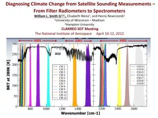
Diagnosing Climate Change from Satellite Sounding Measurements – From Filter Radiometers to Spectrometers William L. Smith Sr1,2.,Elisabeth Weisz1, and Henry Revercomb11University of Wisconsin – Madison2Hampton UniversityCLARREO SDT Meeting The National Institute of Aerospace April 10-12, 2012
Potential Climate Trend SpecificationSatellite Instrument Characteristics 4 - 100 CLARREO SDT April 10-12, 2012
HIRS Vs IASI/AIRS/CrIS Retrieval Resolution Retrieval Vertical Response to Vertical Structure Impulse (after: Rabieret al., ECMWF) CLARREO SDT April 10-12, 2012
Filters to Spectrometers Climate Investigation Objective: To determine whether or not useful climate trend parameters can be obtained from the continuous record of HIRS data dating back to the Nimbus-6 HIRS of 1975. (note: HIRS-4 on Metop-A can be cross calibrated with IASI on Metop-A and then used through Simultaneous Nadir Overpasses to cross calibrate all the NOAA satellite HIRS-3/HIRS-2 and Nimbus-6 satellite HIRS-1 observations) Procedure: Determine the accuracy of HIRS monthly mean climate variables relative to CLARREO project determined AIRS monthly mean values (1) Simulate HIRS from IASI (IASI absolute calibration is comparable to AIRS) (2) Retrieve monthly mean climate variables using same retrieval algorithm that was used for CLARREO AIRS climate parameters (3) Compare Differences of HIRS and AIRS with respect to GDAS specifications as a measure of relative accuracy (i.e., accounts for sampling differences between Metop-HIRS (09:30 orbit) and Aqua-AIRS (13:30 orbit) Next Steps: (1) If results of “A” above are favorable, repeat “A” using actual Metop HIRS rather than Metop IASI simulated HIRS and full resolution IASI radiances. Compare results. (2) Extend processing to all cross-calibrated HIRS data extending back to 1975. CLARREO SDT April 10-12, 2012
Desirable Features of Climate Retrieval Algorithm • Linear dependence on radiance spectra • Variation depends only on radiance • (i.e., no other input variables) • All sky • clear and cloudy (0 - 100%) • Independent of Field-of-View (FOV) size • Can be applied to different instruments • Retrieval Variables • Surface : temperature & spectral emissivity • Atmosphere : T, H2O, and O3 profiles & CO2 ppm • Cloud : height and optical thickness
Dual Regression Retrieval Algorithm • Classified linear Dual-Regression (DR) • Very fast (real-time) all-sky temperature, water vapor, ozone profiles plus surface skin temperature and spectral emissivity, cloud pressure and optical depth and total CO2 concentration retrieval algorithm • Non-linear dependence on cloud pressure and humidity accounted for by classification (9 cloud height / H2O classes within 5 CO2 classes) • Training Data Sets for Robust Retrievals • - Large (15,704 clear sky and 19948 cloudy sky) global all season radiosonde / remote region ECMWF analysis data set • - Cloud altitudes diagnosed from humidity profile • - Surface skin temperature and emissivity and cloud microphysical properties based on empirical data sets with Gaussian random perturbations • - UMBC SARTA and Texas A&M / U. Wisconsin Cloud RTM for radiances CLARREO SDT April 10-12, 2012
Technique – Dual Regression • Linearizes Cloud and Moisture Dependence through classification • Based on single 40-yr Global Profile Data Set & Calculated Radiances Cloud Top Altitude / Cloud Class 1 1 Initial cloud-class selected from 8 200-hPa overlapping cloud layer class regressions (solution is one closest to layer mean) 2 Retrieval below cloud set equal to missing if Max(Tclr-Tcld) >25 K 3 For HIRS, GDAS profile is used in place of “Cloud-Trained Profile” to define cloud class CLARREO SDT April 10-12, 2012
Spectral Channels Used For Profile RetrievalsAIRS (1450/2378), IASI(7021/8461),CrIS (1245/1305), & HIRS (16/20) CLARREO SDT April 10-12, 2012
Climate Variables Retrieved • Temperature Profile (K) • Water Vapor Mixing Ratio Profile(g/kg) • Relative Humidity Profile (%) • Ozone Profile (ppmv) • Surface Skin Temperature (K) • Total Precipitable Water (cm) • CO2 Concentration (ppm) • Cloud-top Altitude (hPa) • Thin Cirrus Cloud-top Altitude (hPa) • Effective Cloud Optical Depth • Atmospheric Stability (Lifted Index) AIRS Climatology based on retrievals from nadir-only full resolution (13-km) observations binned into 10-degree latitude-longitude grid cells CLARREO SDT April 10-12, 2012
Cloud Comparison of MetOp “HIRS” Vs IASI IASI HIRS IASI HIRS CLARREO SDT April 10-12, 2012
Temperature Comparison of MetOp “HIRS” Vs IASI HIRS 850 hPa HIRS 500 hPa IASI 500 hPa IAS 850 hPaI
Monthly Mean Cloud Comparisons (August, 2009) • As can be seen there are large differences between HIRS and AIRS derived cloud parameters. • In general HIRS retrievals show higher altitude and lower optical thickness clouds than does AIRS Cloud Pressure (hPa) Cloud Optical Thickness CLARREO SDT April 10-12, 2012
Monthly Mean 500 hPa Temperature (August, 2009) • HIRS temperature retrieval “errors” are larger than the AIRS “errors”, particularly over the conventional data rich land areas. • HIRS retrieved temperatures are generally colder than the HIRS retrieved temperatures
Monthly Mean 500 hPa Humidity (August, 2009) • HIRS humidity “errors” are comparable to the AIRS “errors” • The spatial distribution of HIRS humidity deviations from GDAS compare favorably with the spatial distribution AIRS humidity deviations from GDAS
AIRS & HIRS Vs GDAS Global Comparisons August 1, 2009 (Note the factor of 2 abscissa scale difference between HIRS and AIRS “error” plots) Mean Stde Mean Stde AIRS minus GDAS AIRS minus GDAS HIRS minus GDAS HIRS minus GDAS 1 K 2 K 4 % 20 % Comparisons with the NCEP Global Data Assimilation System (GDAS) product shows the HIRS DR retrieval errors are about twice as large as those for the AIRS on a global basis. CLARREO SDT April 10-12, 2012
Conclusions • Bad News:The HIRS retrieval errors appear to be too large to provide climate accuracy measurements of atmospheric state for the early detection and magnitude of climate change • Good News: The results presented here validate the need for satellite ultraspectral radiance measurement (e.g., from CLARREO) retrievals for providing atmospheric state measurements with suitable accuracy for the early detection and magnitude of climate change CLARREO SDT April 10-12, 2012