2.75 Miles
70 likes | 222 Vues
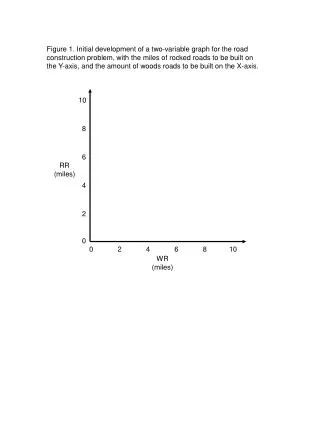
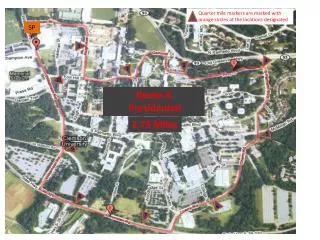
Quarter mile markers are marked with orange circles at the locations designated. SP. 1. 4. 3. 2. 10. Route A. Route A Presidential. 2.75 Miles. 2.75 Miles. 5. 9. 8. 6. 7. Route A marker locations

2.75 Miles
E N D
Presentation Transcript
Quarter mile markers are marked with orange circles at the locations designated SP 1 4 3 2 10 Route A Route A Presidential 2.75 Miles 2.75 Miles 5 9 8 6 7
Route A marker locations • Unless otherwise noted all markers are orange circle painted on the curb • Painted on the curb approximately 20 feet past the intersection • There is no painted marker. Place the cone at the opening of the drain gutter on the left side of the road just before the road intersection • Located at the edge of the 6th green parking line from the end of the parking spaces • Located on the curb (right side) just before the road intersecting with Cherry St • Located on the curb (right side) near the end of the guard rail • Located on the curb (right side) 37 paces before the stop sign • Located on the curb (right side) 25 paces past the speed limit sign • Located on the curb (right side) 16 paces from the end of the concrete wall • There is no painted marker. Place the cone at the intersection • Located on the curb (right side) next to the Cat Bus sign
Quarter mile markers are marked with orange circles at the locations designated 8 7 1 Route B – Single dyke 3.38 Miles 2 3 6 4 5
Route 8 marker locations • Unless otherwise noted all markers are orange circle painted on the curb • There is no painted marker. Place the cone at the intersection • There is no painted marker. Place the cone at the far side of the intersection under the red light between the two signs • Located on the right side of the road about halfway between to two roadways • Located on the curb (right side) just after the right turn. This marker is a blue painted arrow • Located on the right side of the road • Located on the right side of the road • Located on the curb (right side) 18 paces from the right turn • Located on the curb (right side) next to last parking space next to the IPTAY # 1006
Route C - Thornhill 4.02 Miles
Route D extended dyke 4.75 Miles
Route E Sprint Sprint Hill Sprints .71 miles Sprint