Download
1 / 33
360 likes | 593 Vues
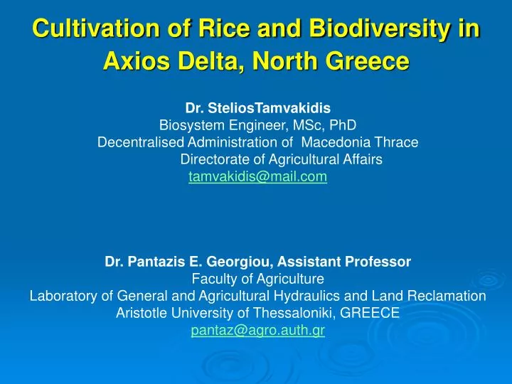
Cultivation of Rice and Biodiversity in Axios Delta, North Greece . Dr. SteliosTamvakidis Biosystem Engineer, MSc , PhD Decentralised Administration of Macedonia Thrace Directorate of Agricultural Affairs tamvakidis@mail.com Dr . Pantazis E. Georgiou, Assistant Professor

E N D
Cultivation of Rice and Biodiversity in Axios Delta, North Greece Dr. SteliosTamvakidis Biosystem Engineer, MSc, PhD Decentralised Administration of Macedonia Thrace Directorate of Agricultural Affairs tamvakidis@mail.com Dr. Pantazis E. Georgiou, Assistant Professor Faculty of Agriculture Laboratory of General and Agricultural Hydraulics and Land Reclamation Aristotle University of Thessaloniki, GREECE pantaz@agro.auth.gr
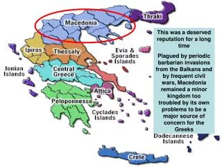
Rice Cropping in Greece Kavala Serres Thessaloniki 16% 8% 58% Main areas of rice cultivation in Greece
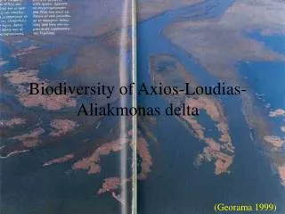
The importance to conserve this area has been recognised since the early 1970s, when it was designated as a Ramsar site. Currently, the area encompasses three Natura 2000 sites (two “Sites of Community Interest (SCIs)” under the Habitats Directive and one “Specially Protected Area (SPA)” under the Birds Directive). Image of the Rivers Part and the AlykiKitros part
The Axios river catchment • The Axios River basin is located in the central Balkan Peninsula and it drains 80% of the Former Yugoslavian Republic of Macedonia (FYROM), parts of Bulgaria and Greece. • Greece occupies the delta area. • The catchment covers an area of approximately 25.000 km2.
City of Thessaloniki from Axios Delta • It hosts a population within the entire Thermaikos Gulf catchment, that is estimated, according to most recent census data, at 3.300.000 inhabitants. • The climate varies between continental to the northern part of the catchment and mediterranean towards the coastal zone.
Satellite Image of the Rivers Part clearly showing rice fields • Over the past decades, the river has suffered numerous human interventions. • In the beginning of the 20th century the river mouth was located a few kilometers SW of Thessaloniki, threatening the access to the port, as a result of continuous siltation. • The river was deviated artificially to the area where it discharges today. • The constructions commenced in 1930 and lasted for four (4) years. • Since then, the river propagated rapidly building an extensive deltaic plain. • However, recent observations have demonstrated that erosional processes has prevailed over the past thirty (30) years.
The wetlands of the Thessaloniki plain, where the Axios delta is located, provide a characteristic example of wetland destruction in Greece. • While in 1917 36% of the plain were wetlands, today this area amounts only to 5.5%. • The main environmental pressures, which affected negatively the delta’s area ecological character, leading to the destruction of 70% of the original wetlands during the 20th century, are numerous: * water discharge decrease * drainage works * urbanization • Pollution • Moreover the general decrease in rainfall, combined with over-use of water for irrigation, has resulted in severe salinization of the delta area, with a direct impact on the flora and fauna of the wetlands. • Nowadays some of these activities have been stopped and their impacts have already been mitigated. Axios Delta
There is no direct control by any state agency for the maximum allowed quantity of fertilizers, pesticides, and herbicides used in the rice cultivation. Usage of toxic pesticides, can have direct impact in the local wild flora and fauna especially in the rice fields, which are a usual habitat for wildfowl.Concerning the water pricing for irrigation, the pricing strategy of the Local Organization of Land Reclamation (LOLR), responsible for the irrigation, does not reflect the full cost of the resource, but intends to cover only running expenses. The pricing policy is based on the average estimated price per hectare that each LORL has set for irrigation. Gallikos Estuaries
Mussel prooduction During the last 20 years, a considerable growth in shellfish (mussel) production appeared in the Axios river coastal area. Today more than 44 pole cultures and 229 long-line cultures occupy the marine area between the Axios River mouth to the NE (Chalastra area), whereas 37 pole and 120 pole cultures are situated to the SW of the Axios river mouth, covering a narrow zone of ~6 km. Shellfish production in the area reaches 85% of the total Greek production,.It increased rapidly since the 1990s to more than 30.000 tones per year, whereas 70-80% of the product is exported.
Mussel producers’ huts in Axios coastal zone The value of the production amounts to more than 10 million € annually, and about 1.000 people are employed in the units.Recently, the production has been considerably affected due to the occurrence of harmful algae blooms (HABs), which sometimes results to the accumulation of toxins in shellfish, being dangerous or even lethal for consumers.
Soils in Rice Fields • Ninety (90%) percent of the cultivated rice area is characterized by pathogenic soils with high salinity. • Therefore, leaching the soil salts, especially at the first stages of the rice plants, and also application of acid fertilizers is absolutely necessary. • An ideal system of rotation is very difficult to be applied because of very high salinity. • In addition there is a significant area (80%) where a 3-year rotation (rice and one year corn, sugar beets and cotton) is applied.
Water Management The aim of rational irrigation is to supply the crop rooting with the necessary water to meet the water needs of spring crops, while achieving a lower loss of water application in the field.In Greece the spring crop water needs can not be filled by summer rains combined with the quantities of soil water stored in the root zone and water is a high phreatic aquifers due to capillary rise contributes to meeting the needs of individual crops For this reason, the application of irrigation for spring crops is essential.Noted that a substantial increase in agricultural production in Greece occurred after 1959 and coincides with the start of construction of collective irrigation networks. In 1998 the total irrigated area was over 12 million stremmas and is now approaching 16 million stremmas. *** 1stremma = 1.000 m2 or 1ha = 10 stremmas
In May (first month of the irrigation season) water losses occur due mainly to rice growing. Significant amounts of water are not lost, but used to fill the basin before sowing rice. During June, July and August, which are the peak demand for water in irrigation period, the losses are smaller. In September (last month of the irrigation season) losses are high, since LOLR’s discharging of water above the crop needs water at the end of the growing season.
The water balance in flooded water of rice fields is described by a general equation in which the sum of inflow is balanced with the sum of outflow and the change in water storage of flooded pond for a time period. The form of this equation is: dV/dt = Ro + GWi - Rro - Rinf + A(R-E) where: V is the volume of ponded water (m3), A is the surface area (m2), R is the rainfall (m d-1), Ε is the evaporation from the free water surface (m d-1), Rois the inflow from the irrigation network (m3d-1), Rinf is the infiltration (m3d-1), GWiis the inflow from groundwater, Rrois the surface runoff (m3d-1). The termdV/dt describes the change in the pond water storage.
The flooded water on the rice field is infiltrated in the soil. • The infiltrated water in the soil moves horizontally to the ditches. The drainage discharge to the ditches is evaluated as a problem of water movement to drains. • Crop evapotranspiration computed with reference evapotranspiration and crop coefficients. • The irrigation practice in the area showed that high water amounts were used. • An important part of applied water (70 to 76 %) lost with surface runoff and contributed to groundwater percolation.
The water balance illustrated that the common irrigation practice, should minimize the use of irrigation water in the area. In the frame of best water management, a program of reduction of water use is needed. Significant part of the total water applied in the field at the last part of growing period. General view of rice paddies in Axios
Environmental Effects of Water, Pesticides and Fertilizers • The irrigation efficiency in open channels’ networks is generally low. • A significant part of the applied water is the return flow to drainage system. It creates very serious environmental impacts such as: • waterlogging, • salinity and • nutrients enrichment of the receiving water bodies (surface and subsurface).
The degree of this irrigation-induced pollution depends on: • hydrogeological characteristics, • the irrigation methods and practice, • the land use and crop distribution and • the water supply and drainage system Applying fertilezers to paddy rice fields
Environmental problemson the wetland of Axios River delta are related with farming practices, especially fertilization and irrigation and the most important are: the salinization of water in the drainage network the waterloggingdownstream which leads to pumping a huge amount of water in order to prevent the waterlogging of soils the nutrient losses from the irrigated area, that influence the eutrophication processes of the Thermaikos Gulf, in northern Aegean Sea.
Water footprint of national rice production (period 2000-04)
Birds More than 270 bird species find shelter in the wetland, many of them rare and threatened. Avocets, Glossy ibises, Black - headed gulls, Dalmatian pelicans, are some of the beauties living here, whilst the riparian forest of Axios hosts one of the most important mixed heron colonies in Greece. The area lies under one of the basic migratory routes of Europe, so thousands of birds stop over for some days in order to rest and feed up, before continuing their journey.
animalsBeside birds, the area of the Axios, Loudias and Aliakmonas estuaries is a valuable habitat for many other animal species, some of which are under threat of extinction, such as the European ground squirrel, the European otter and the Hermann’s tortoise. In the fields and in the islets of the Axios river lives a herd of wild horses, descendants of the animals once used by the farmers for agricultural work. In the Gallikos estuaries one can see an impressive stock of water buffalos, that enjoy spending most of their time in the water.
and plants In total there are more than 500 species and subspecies of plants, some of which change colors during the year, producing a diverse scenery. Some species are rare, such as the Sea daffodil, while others are very common, such as the glasswort, which, in Autumn turns red and adorns the marshlands of the coastal zone to a colorful carpet.
Dalmatian pelican by salicornia vegetation • Contributing factors (indirect threats and opportunities) • Insufficient law enforcement allows the discharge of untreated or inadequately treated industrial and urban sewage to the River and other freshwater ecosystems. Furthermore weak law enforcement enhances illegal activities such as garbage dumping, poaching and improperly conducted or illegal sand extraction. • Weak or absent policies, in particular those related to land use planning, result in poor implementation of the EU-Water Framework Directive, unumberegulated grazing, illegal construction of buildings, intense hunting and waste mismanagement. In addition, low water prices facilitate wasteful irrigation practices. The excessive use of fertilizers and pesticides in the Protected Area and upstream of the rivers are caused by a wide set of factors.
Pygmy cormorant • Inadequate action by the Axios Authority due to the lack of capacity, funding and mandate, is not helping to avoid ongoing construction of buildings in the area, improperly conducted and illegal sand extraction, landfill with construction waste and overgrazing. • Lack of awareness and knowledge of locals, farmers and other stakeholder groups related to the values of the protected area and to the responsibilities and opportunities for primary producers, leads ecologically damaging farming practices, overgrazing, landfill, garbage dumping and hunting/poaching. • Low sense of responsibility of local people to take care of the area, the low accountability of municipality leaders and the fact that waste management ranks low on the political agenda is leading to a heavily devaluated landscape with garbage and waste lying around. • Mentality issues regarding the illegal construction of buildings, in combination with infrastructural requirements of livestock husbandry, fishermen and aquaculture people, the lack of law enforcement and the demand for commercial development along the national road and unclear legislation is leading to landscape degradation and habitat loss.
Dragon fly • The strategies are: • Ensuring ecological improvement of agricultural practices (AP) • Effective implementation of the Water Framework Directive (WFD) • Supporting land use planning for sustainable grazing (GR) • Kalohori lagoon restoration and improvement (KL) • Integration and application of land use planning (LU) • Reducing hunting pressure and poaching (HU) • A garbage campaign (GB) • Sustainable sand extraction management (SEM)
Observatory in Gallikos estuaries • It is assumed that if people value the Axios Delta, that they will then respect the management rules and collaborate in conserving the area. • The strategy specifically aims to: • Raise awareness of general public on values of the Natural Park • Improve visitor information about the National Park & Infrastructure • Use the National Park for the education of schoolchildren (biology lab) • Raise awareness of general public and politicians on the ecosystem services • (water purification, groundwater recharge) and goods (drinking water, water for irrigation, rice, mussels, fish) that the National Park provides. • Attract visitors from the Thessaloniki area and Greek and European tourists
Bird watching day Thank you for your attention