Download
1 / 1
10 likes | 156 Vues
Electromagnetic Field Strength Prediction in Urban Scenario by using GRID Environment. S. Coco, A. Laudani, G. Pollicino. DIEES, Università di Catania.

E N D
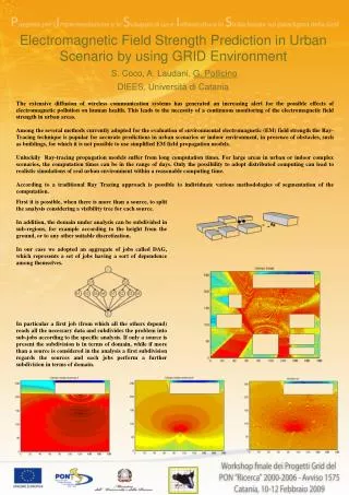
Electromagnetic Field Strength Prediction in Urban Scenario by using GRID Environment S. Coco, A. Laudani, G. Pollicino DIEES, Università di Catania The extensive diffusion of wireless communication systems has generated an increasing alert for the possible effects of electromagnetic pollution on human health. This leads to the necessity of a continuous monitoring of the electromagnetic field strength in urban areas. Among the several methods currently adopted for the evaluation of environmental electromagnetic (EM) field strength the Ray-Tracing technique is popular for accurate predictions in urban scenarios or indoor environment, in presence of obstacles, such as buildings, for which it is not possible to use simplified EM field propagation models. Unluckily Ray-tracing propagation models suffer from long computation times. For large areas in urban or indoor complex scenarios, the computation times can be in the range of days. Only the possibility to adopt distributed computing can lead to realistic simulations of real urban environment within a reasonable computing time. According to a traditional Ray Tracing approach is possible to individuate various methodologies of segmentation of the computation. First it is possible, when there is more than a source, to split the analysis considering a visibility tree for each source. In addition, the domain under analysis can be subdivided in sub-regions, for example according to the height from the ground, or to any other suitable discretization. In our case we adopted an aggregate of jobs called DAG, which represents a set of jobs having a sort of dependence among themselves. In particular a first job (from which all the others depend) reads all the necessary data and subdivides the problem into sub-jobs according to the specific analysis. If only a source is present the subdivision is in terms of domain, while if more than a source is considered in the analysis a first subdivision regards the sources and each jobs perform a further subdivision in terms of domain.