Download
1 / 1
10 likes | 166 Vues
Irrigation Distribution Network Modeling for the Lower Rio Grande Valley of Texas Yanbo Huang, Guy Fipps Biological and Agricultural Engineering Department, Texas A&M University, College Station, TX 77843-2117. Introduction

E N D
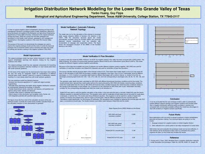
Irrigation Distribution Network Modeling for the Lower Rio Grande Valley of Texas Yanbo Huang, Guy Fipps Biological and Agricultural Engineering Department, Texas A&M University, College Station, TX 77843-2117 Introduction In order to support irrigation district rehabilitation planning and day-to-day management decisions a prototype model of water distribution networks is being developed and applied at the Biological and Agricultural Engineering Department of Texas A&M University. Compared to the original prototype (Huang and Fipps, 2003) the current one has been designed and developed to much better meet hydraulic, geographic and management requirements in the irrigation systems in the Lower Rio Grande Valley (LRGV). The purpose of this work is to demonstrate the strategies we used to improve the original prototype model and the works to verify the improved prototype and to reveal the further works to develop and apply the model for training and decision making in the irrigation systems in the LRGV. Model Verification I: Automatic Following Network Topology The model was run for the calculation of the volumes in municipal water supply networks (MSN) of fourteen (14) districts in the LRGV. With the calculation structure above the model automatically proceeds along the fourteen MSNs and produced balanced volume relationships over the networks with incorporation of seepage and evaporative losses. The figure shows the topological structure of the MSNs of the fourteen districts in the LRGV. Model Improvement Model Verification II: Flow Simulation • The original prototype model has been further improved in order to better support rehabilitation planning and decision making for the irrigation systems in the LRGV. • The original prototype model has two separate components for branching open-channel and pipeline networks handling in or near steady-state flows with small hydraulic gradients. • On the basis of the original one the improvements have been done making the new one being an integrated model for combinations of different channel types (canal, pipeline, reservoir or resaca) of distribution network handling in or near steady-state flows with small hydraulic gradients. • The new prototype model has following features: • Modular and recursive algorithms C++ coded with object-oriented programming • Simulate flows (discharge and depth) along irrigation distribution networks by automatically following the topology of networks • Handle lined/unlined canals, reservoirs and resacas, and pipelines and siphons along mains, laterals and takeouts • Consider water losses in seepage and evaporation • Able to plug in in-line structures, such as gates, weirs, flumes, etc. • GIS integrated potential with specified data structures In order to verify the model the MSN of Mission 16 (HCID 16) irrigation district in the valley has been surveyed with a GPS system. The MSN of Mission 16 consists of a pressurized upstream pipeline (about 6,000 ft) and a downstream canal (about 4,000 ft). The model handles the different irrigation systems together automatically.Because no flow data was available and none of software can handle different irrigation systems together, HEC-RAS was used for verification of canal flow simulation and WaterCAD (Haestad) was used for verification of pipe flow simulation.The survey indicates that the physical depth of the channel is about 5.5 ft. That means that if water depth is over 5.5 ft, the canal will flood. In the calculation of HEC-RAS the boundary condition was assigned in two ways. One is to fix a “reasonable” level for different discharges, i.e. 4.5 ft. Another is to quantize depth levels for different discharges with a uniform interval, i.e. divide 5.5 by 6 for six discharges producing depth levels (ft): 0.92, 1.83, 2.76, 3.68, 4.6, and 5.52 corresponding to discharges (cfs): 25, 50, 75, 100, 125, and 150. The upstream water depth has been calculated by HEC-RAS with different downstream boundary conditions and by the model. The results indicate that in general they match pretty well and the result produced by HEC-RAS with linearly varied boundary conditions match the model better than the ones by HEC-RAS with fixed boundary condition because the varied boundary conditions adapts to the change of the discharge in some degree. So, in practice it is very important for HEC-RAS user to pick “reasonable” boundary condition for the corresponding discharge level while the model is not sensitive to it. WaterCAD was used to verify the pipeline calculation of the model. In the real world the pipe is concrete. WaterCAD uses the Hazen-Williams equation to calculate the friction loss. This equation works well for moderately smooth pipes but not accurate for rough pipes, small pipes, or laminar flow. The model uses Darcy-Weisbach equation. This equation is can be used for a variety of liquids and gasses, for laminar and turbulent flow, and for rough or smooth pipes. With the different equations for the concrete pipe the calculations varied significantly. For the purpose of verification, the calculations were changed by replacing the concrete pipe with PVC pipe, a conventional smooth pipe. The results indicate much better match between WaterCAD and the model. Conclusion It can be concluded that the new prototype model is able to automatically handle different network topology and irrigation systems and simulate water flow in irrigation distribution networks pretty accurately in practice and compared with commercially available software the model has advantages to deal with problems in irrigation systems specifically. The figure shows the flow chart of the calculation structure of the new prototype model. Currently the model mainly handles subcritical flows, so the calculation direction is from downstream to upstream. Mean Square Errors (MSE) Relative to the Model Future Works More applications will to be done to answer questions in district rehabilitation planning and decision making. Two coming projects are going to run the model: • Seepage analysis for a pipeline system in United Irrigation District • Gate calibration for a canal system to aid daily management of canal riders With further test and evaluation the prototype model can be more effective. A GIS interface will be developed to allow users to schematize the system, organize the data, run the model and visualize the results. Reference Y. Huang and G. Fipps. 2003. Modeling flows in irrigation distribution networks – model description and prototype. Paper No. 032146. ASAE, St. Joseph, MI.