Download
1 / 17
170 likes | 198 Vues
Learn about GPS modernization, system improvements, and international collaboration at the 2007 workshop in Rabat, Morocco. Explore the latest advancements in space technology for sustainable development.

E N D
GPS Constellation Update International Workshop on the Use of Space Technology for Sustainable Development Rabat , Morocco 25-27 April 2007 Dr. Fernando Echavarria U.S. Department of State
Overview • System Improvements & Modernization • GPS Constellation Status • Next Steps for Space and Control Segments • Interoperability & International Collaboration • Summary
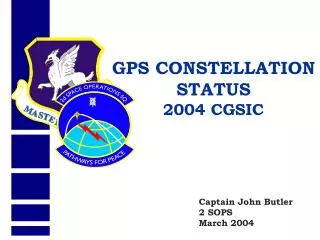
GPS Constellation Statusas of 9 Mar 07 29 Healthy Satellites Baseline Constellation: 24 • 14 Block IIA satellites operational • 12 Block IIR satellites operational • 3 Block IIR-M satellites operational • 5 additional IIR-M satellites to launch • Since Dec 93, U.S. Government met/exceeded civil GPS service performance commitments • SPS Performance Standard (PS) • U.S. committed to superior GPS service
Overview • System Improvements & Modernization • GPS Constellation Status • Next Steps for Space and Control Segments • Interoperability & International Collaboration • Summary
P(Y) C/A L2C M L5 L1C L5 L1 L2 GPS Modernization – Spectrum Block IIA, 1990 previous as of Dec 2005 Block IIR-M, 2005 planned Block IIF, 2008 Block III, 2013 (artist’s concept) ARNS BandRNSS BandARNS Band
GPS Evolutionary “System-of-Systems” Programs Space Segment • Modernized(Block IIR-M) • 2nd civil signal (L2C) • M-Code signals (L1M, L2M) • Anti-jam flex power • Modernized(Block IIF) • 3rd civil signal (L5) GPS III(Block III) • Increased accuracy • Increased A/J power • Signal integrity • Search and Rescue • L1C civil signal common w/Galileo, QZSS, & possibly GLONASS • Legacy(Block IIA/IIR) • Std Service (≤ 6 meters RMS SIS SPS URE) • Single frequency (L1) • Coarse acquisition (C/A) code navigation • Precise Service (≤ 2.6 m 95% URE PPS at Zero AOD) • Y-Code (L1Y & L2Y) • Y-Code navigation Ground Segment Legacy • TT&C • L1 & L2 monitoring Upgraded(AEP) • IIR-M IIF TT&C • WAGE, AII, LADO • NMCS/AMCS Modernized(OCX V1) • New Architecture • Signal Monitoring GPS III(OCX V2) • GPS III TT&C • Real-Time C2
Modernizing the operational control segment (OCS): Legacy Accuracy Improvement Initiative (L-AII) • Each SV tracked by three or more monitor stations over 99% of time • Zero age-of-data URE improved from ~46 cm to ~27 cm • L-AII SIS URE improved from ~1.25 m to ~1.05 m
Overview • System Improvements & Modernization • GPS Constellation Status • Next Steps for Space and Control Segments • Interoperability & International Collaboration • Summary
International Cooperation • Past decade of intensive diplomacy on GNSS issues • 1996 - First State Department-led GPS team visits Tokyo • 1997 – Bid at WRC to share GNSS frequency band with other services narrowly averted • 1997 – First US-EU discussions on satellite navigation • 1998 to present – GNSS consultations with more than two dozen countries • Positive results of these efforts beginning to be seen • New satellite constellations and regional augmentations systems, while independently owned and operated, are being designed to be compatible and interoperable • Coordination mechanisms are being created to promote interoperability, promote GNSS use, and ensure a level playing field in the global marketplace
GPS-Galileo Cooperation • In 2004, United States and European Community signed landmark agreement on GPS-Galileo cooperation • Recognizes importance of compatibility/interoperability for all parties • Agreed to spectrally separate signals for military and civilian services • Agreed to implement a common, open, civil signal on both Galileo and GPS III • Working Groups establishedto continue dialogue: • Compatibility & Interoperability • Trade & Civil Applications • Next-Generation GNSS • Security Issues • Joint Handout on “GPS and Galileo… Progress Through Partnership” distributed at Munich Summit June 26, 2004, press conference at U.S.-EU Summit in Ireland (U.S. Sec. of State Colin Powell, Irish Foreign Minister Brian Cowen, EU Vice-President Loyola De Palacio)
US-Japan Cooperation • Japan’s status as a world leader in GPS applications and user equipment makes it an important partner • Policy consultations and technical meetings on GPS cooperation have been held since 1996 between the United States and Japan • Discussion topics include Japan’s regional augmentation system (MSAS) and interoperability between GPS and Japan’s planned Quasi-Zenith Satellite System (QZSS)
GPS-GLONASS Cooperation • Discussions on US-Russia agreement on satellite navigation cooperation have been underway since late 2005 • Next meeting is planned for second half of 2007 • Working groups are pursuing GPS-GLONASS interoperability • Enhanced PNT availability through common open service civil signals • Cooperative search and rescue capabilities
US-India Cooperation • Policy and technical consultations on GPS cooperation have been held since 2005 between the US and India • One aim: ensure interoperability between GPS augmentation system WAAS and India’s planned GAGAN augmentation system based on GPS • Another important topic is research into ionospheric distortion and solutions • US-India Joint Statement on GNSS Cooperation issued in February 2007 in Washington
Summary • Continuing success in GPS sustainment & modernization • New capabilities delivering enhanced performance • Developments on track to enhance space and control segments • International Collaboration • Excellent cooperation with civil service providers • Improving RNSS interoperability/compatibility for best GNSS