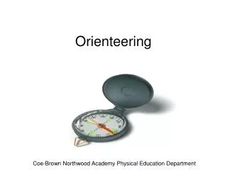
Orienteering
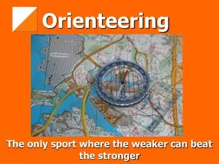
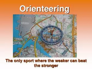
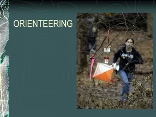
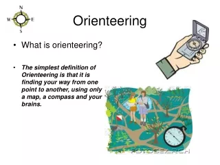
Orienteering. Orienteering. Orienteering is a competition where participants use a map and compass to navigate from point to point in the least amount of time. Orienteers use highly detailed maps to find markers called controls that have been place in the landscape.

Orienteering
E N D
Presentation Transcript
Orienteering Orienteering is a competition where participants use a map and compass to navigate from point to point in the least amount of time. Orienteers use highly detailed maps to find markers called controls that have been place in the landscape. In most orienteering events, the participant must locate the controls in a specified order.
Orienteering The routes between the controls are not specified. The orienteer must choose routes between controls, navigate that route, and do so as quickly as possible.
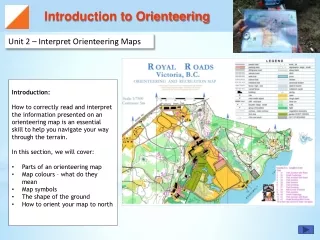
The Course The orienteering course consists of a start, a series of control markers, and a finish. A participant is given a map, a control card, and a clue sheet. The control card is used to note the start and finish time, and to verify that the orienteer has visited each of the control markers on the course. The map is used to mark the start and finish locations, as well as the locations of each of the control markers.
The clue sheet has clues describing the placement of each of the control markers - the type of geographical features at which the marker as been placed - and a “control code” which identifies the marker. The Course
Successful Orienteering Success in orienteering requires a number of different skills. The winner of the competition is the participant who completes the course in the shortest time, so running ability is beneficial. The orienteer must be able to read the map, select an appropriate route from one control point to the next and successfully follow that route.
Successful Orienteering Map reading and analysis skills are by far the most crucial. A successful orienteer will develop the ability to observe the terrain around them, look at the map and identify where they are. They will develop the ability to determine the quickest route between points, as well as the navigational skills to traverse that route.
Orienteering Skills / Strategies Orient your Map An important strategy for successful orienteering is to orient your map. This means that north on the map is kept physically turned towards north in the real world. Using your compass, rotate the map so north on the map is turned to north on your compass. By keeping your map oriented, you will reduce the tendency to become disoriented yourself.
Orienteering Skills / Strategies Stay in Contact Always keep in contact with the map. You should know at all times exactly where you are on the map, and what direction you are headed. To do this, keep your map oriented. Constantly look from the map to the terrain and back again. Note features on the map, and make sure you can identify them in the landscape around you, and vice-versa. If something doesn’t look right - a feature on the map that you don’t see around you - stop immediately and reo rient yourself.
Orienteering Skills / Strategies Handrails Use linear features as “handrails”. A handrail is any linear feature - like a trail, power line, stream, fence, or vegetation boundary - that you can “hand on to” or follow. As you plan your route, look for things you can follow.
Orienteering Skills / Strategies Handrails At the beginning these handrails will probably be trails or roads that are very easy to follow. As you begin doing intermediate level courses, start looking for streams, ridges or vegetation boundaries.
Orienteering Skills / Strategies Handrails Following a handrail may make your route slightly longer, but the advantage is that you are much less likely to become disoriented or lost.
Orienteering Skills / Strategies Break it Up Often, on advanced courses, there are no true linear features to follow. In these instance, look for a series of features that more or less make a like in the direction you wish to travel. Break the route into several smaller ones.
Orienteering Skills / Strategies Break it Up Start at a dry stream
Orienteering Skills / Strategies Break it Up Pass a clearing
Orienteering Skills / Strategies Break it Up Follow the trail until it bends left
Orienteering Skills / Strategies Break it Up Pass a clearing
Orienteering Skills / Strategies Break it Up Pass a cluster of boulders
Orienteering Skills / Strategies Break it Up Pass another clearing
Orienteering Skills / Strategies Break it Up Follow the ridge past another boulder
Orienteering Skills / Strategies Break it Up Follow it until you find the control marker
Orienteering Point 1 - (bend in the hill) The triangle marks the starting point. You see you are on a large trail and should follow it until it forks, the turn right.
Orienteering Point 1 - Immediately the path forks again and you go right again to the sharp bend where the first red and white maker hand. Punch card and choose next route.
Orienteering Point 2 - (Hill) You decide to follow the trail south to the junction and turn right, then onward to the next right turn, then a left turn.
Orienteering Point 2 - You notice the trail going slightly downhill then slightly up again. This must be the small hill. You look to the left and see the second control.
Orienteering Point 3 - (Stream Junction) It would probably be best to go back to the trail and follow it to the stream then go southwest to the next stream junction.
Orienteering Point 4 - (Large boulder, west side) If you continue to go downstream you will soon pass one boulder then another which is south of the stream bed and a third in the steam.
Orienteering Point 4 - This is your place to turn east to the large boulder.
Orienteering Point 5 - (Fork in the ditch) Go south a short distance to the trail and start uphill. The trail bends north - pass two buildings, then turn right at trail junction and come to ditch.
Orienteering Point 6 - (Clearing, west corner) It is a long way around on the trail to the clearing so try your compass. Set compass towards the corner of the clearing.
Orienteering Point 6 - After studying the map you can see that you can wander slightly to the north there is nothing to stop you, so you go a little south on your compass bearing.
Orienteering Point 6 - You follow the compass into the woods and pass a pond, boulder cluster and a well. You see a bright spot in the woods. It is the clearing.
Orienteering Point 7 - (Knoll) You go east through the clearing to the trail, go northeast to small trail and turn right. Trail leads you to stream.
Orienteering Point 7 - Continue downstream to the junction and follow the other fork upstream and you will come to the knoll.
Orienteering Point 8 - (Trail Junction) Follow the stream up to the end and continue in same direction to the trail - turn right to the junction. You found the last control.