Download
1 / 5
50 likes | 424 Vues
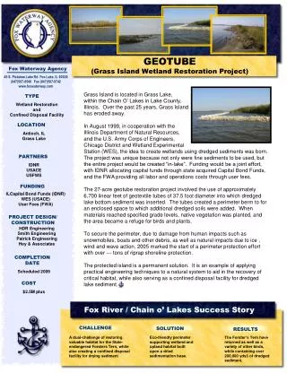
GEOTUBE (Grass Island Wetland Restoration Project). Fox Waterway Agency. 45 S. Pistakee Lake Rd Fox Lake, IL 60020 (847)587-8540 Fax (847)587-9742 www.foxwaterway.com. Grass Island is located in Grass Lake, within the Chain O’ Lakes in Lake County,

E N D
GEOTUBE(Grass Island Wetland Restoration Project) Fox Waterway Agency 45 S. Pistakee Lake Rd Fox Lake, IL 60020 (847)587-8540 Fax (847)587-9742 www.foxwaterway.com Grass Island is located in Grass Lake, within the Chain O’ Lakes in Lake County, Illinois. Over the past 25 years, Grass Island has eroded away. In August 1999, in cooperation with the Illinois Department of Natural Resources, and the U.S. Army Corps of Engineers, Chicago District and Wetland Experimental Station (WES), the idea to create wetlands using dredged sediments was born. The project was unique because not only were fine sediments to be used, but the entire project would be created “in-lake”. Funding would be a joint effort, with IDNR allocating capital funds through state acquired Capital Bond Funds, and the FWA providing all labor and operations costs through user fees. The 27-acre geotube restoration project involved the use of approximately 6,700 linear feet of geotextile tubes of 37.5 foot diameter into which dredged lake bottom sediment was inserted. The tubes created a perimeter berm to for an enclosed space to which additional dredged soils were added. When materials reached specified grade levels, native vegetation was planted, and the area became a refuge for birds and plants. To secure the perimeter, due to damage from human impacts such as snowmobiles, boats and other debris, as well as natural impacts due to ice , wind and wave action, 2005 marked the start of a perimeter protection effort with over --- tons of riprap shoreline protection. The protected island is a permanent solution. It is an example of applying practical engineering techniques to a natural system to aid in the recovery of critical habitat, while also serving as a confined disposal facility for dredged lake sediment. TYPE Wetland Restoration and Confined Disposal Facility LOCATION Antioch, IL Grass Lake PARTNERS IDNR USACE USFWS FUNDING ILCapital Bond Funds (IDNR) WES (USACE) User Fees (FWA) PROJECT DESIGN/ CONSTRUCTION HDR Engineering Smith Engineering Patrick Engineering Hey & Associates COMPLETION DATE Scheduled 2009 COST $2.5M plus Fox River / Chain o’ Lakes Success Story CHALLENGE SOLUTION RESULTS A dual-challenge of restoring valuable habitat for the State-endangered Forsters Tern, while also creating a confined disposal facility for drying sediment Eco-friendly perimeter supporting wetland and upland habitat built upon a dried sedimentation base. The Forster’s Tern have returned as well as a variety of other birds, while containing over 200,000 yds3 of dredged sediment.
PAPE ISLAND Fox Waterway Agency 45 S. Pistakee Lake Rd. Fox Lake, IL 60020 (847)587-8540 Fax (847)587-9742 www.foxwaterway.com Pape Island is immediately adjacent to the main navigational boating channel for boats traveling north and south between the lakes of the Chain O’Lakes and the Fox River. Excessive wave activity caused both by boating and wind fetch across Pistakee Lake had caused severe erosion of the Pape Island shoreline. Other unique strains to the island are ice floes and stacking, ice expansion and an annual eighteen-inch plus winter drawdown. In 2001, in collaboration with over 17 Federal, State and local partners, V3 Consultants was hired to do a comprehensive evaluation of alternative bio-engineered bank stabilization measures. Comparative effectiveness for shoreline stabilization of the island was established with respect to the following parameters: high wave action due to wind fetch and high boat traffic, icing in the winter, high flood flows during spring and early summer months, and an eighteen-inch drop in water elevation due to winter draw down procedures. Five stabilization methods were ultimately chosen, as follows: Joint Planting: Method consisted of a fortified rip-rap toe and base with both an emergent planting zone interspersed with live stake woody planting zones. Vegetated Gabion Basket: Method consisted of vegetated gabion baskets surrounding the rip-rap rock toe and base with both an additional emergent planting zones and live stake woody planting zones. Log and Rootball Revetment: Method is similar to joint planting with the addition of buried log tree trunks with root balls structures directed towards the lake. These root balls provide a physical break to the wave action before it reaches the shoreline while also providing habitat benefits for fish, small animals and aquatic insects. Lunker Structure: Method is similar to the joint planting method with the addition of large square concrete boxes buried into the rip-rap with emergent planting zones and live stake woody planting zones providing vegetative stabilization to the shoreline on top. Fisheries habitat is provided as the boxes create a submerged undercut bank shelter area. Concrete Block: Method consists of a fortified rip-rap rock base with a concrete block mat placed from the toe to the top of the river slopes. Emergent plantings and live stake woody plantings occur within the void space of the concrete block mat to provide vegetative stabilization to the shoreline. TYPE Bio-engineered Shoreline Stabilization LOCATION McHenry, IL Pistakee Lake PARTNERS Illinois Dept of Natural Resources US Army Corps Engineers-CHGO US Fish and Wildlife Lake Co Stormwater Lake Co Planning&Development McHenry County P&D FUNDING IL Capital Bond Funds (IDNR) User Fees (FWA) PROJECT DESIGN/ CONSTRUCTION V3 Consultants V3 Construction FWA staff COMPLETION DATE 2004 COST $1.2M Fox River / Chain o’ Lakes Success Story CHALLENGE SOLUTION RESULTS Restore a severely eroded shoreline at one of the busiest and most traveled parts of the Fox River Chain O’Lakes waterway. Showcase five (5) bio-engineered shoreline stabilization methods that can effectively withstand highly erosive conditions. A natural and diverse ecosystem has been re-established and is aesthetically pleasing, while also preventing further erosion.
ACKERMAN ISLAND Fox Waterway Agency 45 S. Pistakee Lake Rd. Fox Lake, IL 60020 (847)587-8540 Fax (847)587-9742 www.foxwaterway.com Ackerman Island is the original three-cell re-useable hydraulic dredge drying site built in the early 1980’s. Throughout its use, it had experienced severe shoreline erosion along its west and northwest shorelines that had impacted the structural integrity of the levee system surrounding the cells. The Fox Waterway Agency secured Smith Engineering to re-engineer this island for modern use. TYPE Shoreline Stabilization and Dewatering Site LOCATION Antioch, IL Nippersink Lake With funding from the IDNR, the rehabilitation of the island was completed. Improvements include a new access road to allow trucks/equipment access, outfall pipe modifications, restructuring of the weir (de-watering structure), access platform for sampling, and a complete bio-engineered bank stabilization improvement. Soils, channel bottom, geotechnical investigations and wetlands delineation and associated permitting. In Spring/Summer 2007 we completed our Ackerman Island Dewatering Facility Improvements Project. The project consisted on contracting shoreline stabilization along the west and northwest sides with 2,123 cy of clay. 0.6 acres of tree removal, 1,128 tons of rip rap, 933 cy of topsoil, approximately 6 root wads, and 875 sq yd of seeding, upgrading the access road to the island, and reconstructing the weir (de-watering outlet structure). PARTNERS IDNR USACE FUNDING IL Capital Bond Funds (IDNR) User Fees (FWA) PROJECT DESIGN/ CONSTRUCTION SEC Group, Ltd. Copenhaver Construction COMPLETION DATE October 2007 American Public Works Association Chicago Metro Chapter – Lake Branch Environment Less Than $2 Million 2008 Project Of The Year Award AWARD COST $1.2M Fox River / Chain o’ Lakes Success Story CHALLENGE SOLUTION RESULTS Restore sediment drying site for ongoing dredging activities, using ecological features to enhance the aesthetic appearance for recreational boaters in this heavy traffic area and for habitat enhancement. Eco-friendly perimeter utilizing bio-engineered techniques. Used native and meadow plantings, maintained the natural tree buffer, and incorporated fish cover through root balls. Commercial grade reusable site, which co-exists with nature. A rookery of eagles, blue herons and other water birds, as well as high quality fishing habitat.
CHAIN O’LAKES STATE PARK Fox Waterway Agency 45 S. Pistakee Lake Rd. Fox Lake, IL 60020 (847)587-8540 Fax (847)587-9742 www.foxwaterway.com The Fox Waterway Agency (‘FWA’) required a 22-acre wetland restoration to be conducted to meet mitigation requirements for a boat slip dredging operation being conducted on the Chain O’Lakes State Park property. The dredging was granted approval under the Interagency Wetland Policy Act and was authorized to impact 0.69 acre of jurisdictional emergency wetland within the Park. The Illinois Department of Natural Resources provided oversite of the project prepared by others. Native species, hunting and site access restricted the time available for the construction activities. The mitigation includes enhancement of approximately 3.7 acres of existing wetland and restoration. Wetland acreage restored in excess of that required for this project will be used as wetland mitigation credit by the FWA for future obligations. The restoration/enhancement activities were initiated in January 2004, following a selection of a suitable parcel in within the park. Year one (1) of the five(5) year management and monitoring period began in 2004. Pre-planting management activities including herbicide were conducted to prepare the site for the seeding with native wetland grasses and wetland buffer plants. A drain tile investigation was conducted to determine the most appropriate method of abandonment to meet the permit performance standards imposed on the project. Several drain tiles were abandoned to modify the groundwater and allow for the growth of the re-introduced native species. TYPE Wetland Restoration LOCATION Spring Grove, IL Chain O’Lakes State Park PARTNERS IDNR USACE USFWS FUNDING IL Capital Bond Funds User Fees PROJECT DESIGN/ CONSTRUCTION Burke, LLC COMPLETION DATE 2004 COST 600K Fox River / Chain o’ Lakes Success Story CHALLENGE SOLUTION RESULTS Mitigation for a 0.69 acre parcel of wetlands that needed removal during construction of the L-10 facility. Through multiple interagency cooperative efforts, mitigation for this public project was allowed to take place on state property—thus restoring valuable wetland acreage at Chain O’Lakes State Park, while complying with regulations for mitigation. Year 2008 Annual Report showed that the wetlands are established and mother nature is bouncing back.
COOPER’S FARM Fox Waterway Agency 45 S. Pistakee Lake Rd. Fox Lake, IL 60020 (847)587-8540 Fax (847)587-9742 www.foxwaterway.com In a partnership between the Illinois Department of Natural Resources (IDNR) and the Fox Waterway Agency, the development of the Cooper’s Farm dredged sediment dewatering soils farm will allow reuse of tens of thousands of tons of eroded topsoil from Wisconsin and northeast Illinois that settles in the Fox River and Chain O’ Lakes annually. Removing this sediment/soil will not only improve the water quality of the lakes, but will also restore navigability thereby increasing recreational opportunities and property values. Having this site designed as a reusable dewatering site, will insure that these lakes and channels are maintained well into the future. While these soils have been used by landscapers, developers and numerous Villages and municipalities in the Lake and McHenry county area for several years, it is intended that this site will allow a potential revenue stream for future water quality projects through the marketing of these clean soils. To insure the highest degree of safety and environmental soundness, the Agency has designed this Sediment Storage and Dewatering Facility (SDF) beyond required standards for its intended use. Within this State-owned 23-acre former agricultural field, this SDF design will include two earthen dewatering cells (approximately 7.11 acres in total size) for storing and dewatering dredged sediment/soils from multiple sources (i.e. Grass Lake, Lake Marie and associated connecting channels) and an area for soil stockpiling, blending and processing (approximately 2 acres in total size) to support beneficial reuse of the sediment/soils. The Agency intends the site to be sustainable and the cells reusable. Periodic removal, likely on an annual basis, of the accumulated sediment from the storage cells will allow recovery and reuse of the cells, as well as annual cell integrity inspections. The current tree line and canopy cover leading to the cells will be maintained, providing a screen from street view, with the exception of the driveway. TYPE Soils Recycling Facility LOCATION Antioch Township, IL PARTNERS FWA LEGISLATIVE CAUCUS IDNR FUNDING IL Capital Bond Funds Mud-To-Parks Program PROJECT DESIGN/ CONSTRUCTION HDR Engineering Copenhaver Construction COMPLETION DATE Target - December 2010 COST 880K Fox River / Chain o’ Lakes Success Story CHALLENGE SOLUTION RESULTS Fund the removal of sediment entering the Chain O’Lakes at a rate at least equal to the 60,000 CY received annually from Wisconsin. Use existing and vacant State owned property, and seed monies from Illinois capital funds, to create a facility to beneficially reuse sediment and create a funding source. The site will have potential to remove/sell 130,000 CY of lake sediment creating a $1.5M revenue stream annually.