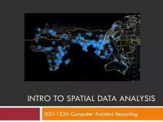
Introduction to Spatial Analysis: Exploring GIS Queries and Distance Measurement Techniques
This lecture covers the fundamentals of spatial analysis, focusing on 2D queries in GIS. Key topics include assessing sizes of geographical features like lakes, measuring trail lengths, counting campus fire hydrants, and determining proximities to academic buildings. The distinctions between aspatial and spatial queries are explained, with examples illustrating conventional and Manhattan distance calculations. Overlaying vector layers, buffering techniques, and raster reclassification are also discussed as essential tools for effective spatial data analysis. The importance of spatial analysis in transforming GIS data into meaningful information is emphasized.

Introduction to Spatial Analysis: Exploring GIS Queries and Distance Measurement Techniques
E N D
Presentation Transcript
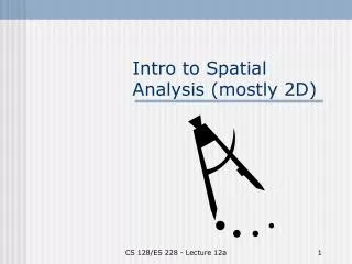
Intro to Spatial Analysis (mostly 2D) CS 128/ES 228 - Lecture 12a
Some GIS Queries • How big is the lake? • What is the longest trail? • How many fire hydrants on campus? • Which dorms are within 100 m of an academic building? • Where is the best place for a new dorm? CS 128/ES 228 - Lecture 12a
Types of queries • Aspatial – make no reference to spatial data • Which dorm has the highest occupancy rate? (we can already do) • Spatial – make reference to spatial (and possibly attribute) data • Which fire hydrant is closest to the chemistry labs? (we can sort of do) CS 128/ES 228 - Lecture 12a
Time for some geometry! CS 128/ES 228 - Lecture 12a
“Simple” spatial queries • How long is this line? • “Tricky” if line is a bunch of line segments • “Tricky” if distance isn’t Pythagorean • How much area does this polygon cover? (Can we do this?) • Is this point in this polygon? (Can’t do this!) CS 128/ES 228 - Lecture 12a
Conventional Distance • The Pythagorean Theorem helps us compute “conventional” distances in the plane • Of course ArcMap does it automatically CS 128/ES 228 - Lecture 12a
“Alternative” distance B • “Manhattan” distance • How many blocks (via a taxi cab) from A to B? • ArcMap can do this in a query/report A What about one-way streets? CS 128/ES 228 - Lecture 12a
Not your mother’s “Distance” More complex distances require more complex analysis CS 128/ES 228 - Lecture 12a
A B C Area (by vector) • Area of a rectilinearly aligned trapezoid is easy. C*(A+B)/2 CS 128/ES 228 - Lecture 12a
Area (by vector) • For a polygon, add up the (signed) trapezoidal areas CS 128/ES 228 - Lecture 12a
or Area (by Raster) • Simply count the rasters inside the polygon How big is this? CS 128/ES 228 - Lecture 12a
Area (by ArcMap) CS 128/ES 228 - Lecture 12a
2 Crossings => OUTSIDE 3 Crossings => INSIDE Points in Polygon • Send out a “ray” and count the crossings. • ODD implies inside • EVEN implies outside CS 128/ES 228 - Lecture 12a
Overlaying vector layers Spatial information (from layers) can be used to create new spatial information (i.e. new layers) CS 128/ES 228 - Lecture 12a
Overlaying Layers (Intersection) • Keep only those things that belong to both layers • Example: Overlay my property with a hydrology layer • Learn how much of my “land” is under water. • What to do about the property boundary and the lake? CS 128/ES 228 - Lecture 12a
Overlaying Layers (Intersection) • Keep any things that belong to either layer • Example: Overlay state highways layer and local roads layer to create pavement layer Note: New Layer not actually created in this figure CS 128/ES 228 - Lecture 12a
Overlaying Layers (Clipping) • Keep only those things from a given layer that lie within a specified boundary (often rectangular) • Example: Consider only those roads that lie within Cattaraugus County • Problem: What if a road crosses the boundary? CS 128/ES 228 - Lecture 12a
DIGRESSION: What are rasters? • Vector layers with a single attribute datum? CS 128/ES 228 - Lecture 12a
Overlaying Rasters • Simple Mathematics will often suffice • But there is less information CS 128/ES 228 - Lecture 12a
Effective Overlaying via Reclassification • Data is not always in a good format • If raster pixels have different coverages, overlaying may be effectively impossible • Codings are generally categorical, not mathematical • Adding codings usually does not make sense • Solution: RECLASSIFY CS 128/ES 228 - Lecture 12a
A Sample Reclassification CS 128/ES 228 - Lecture 12a
Buffering – another tool • Buffering (building a neighborhood around a feature) is a common aid in GIS analysis CS 128/ES 228 - Lecture 12a
Using Buffers to Select • Select the features • Save the features as a layer • (Export) CS 128/ES 228 - Lecture 12a
Putting it all together • Siting a nuclear waste dump • Build Layer A by selecting good geology • Build Layer B by reclassifying population for high density • Build Layer C by clipping B from A • Build Layer D by buffering roads • Build Layer E by intersecting C and D • … See also: Box 6.5, pp. 187-88 CS 128/ES 228 - Lecture 12a
Where does it fit in? • GIS holds data • Spatial analysis causes us to view the data as information • Combining queries turns that information into knowledge (It’s all a spectrum) CS 128/ES 228 - Lecture 12a
Conclusions • A GIS without spatial analysis is like a car without a gas pedal. There are some things you can still do with it, but it’s hardly worth maintaining the vehicle. CS 128/ES 228 - Lecture 12a