Download
1 / 18
200 likes | 327 Vues
SPC SOPAC Division. 2011 Heads of Fisheries Meeting - Maritime Boundaries Brief. Dr Arthur Webb, Deputy Director OIP. Applied Geoscience & Technology Division – SOPAC l.

E N D
SPCSOPAC Division 2011 Heads of Fisheries Meeting - Maritime Boundaries Brief. Dr Arthur Webb, Deputy Director OIP. Applied Geoscience & Technology Division – SOPAC l 2010 – 2011 Rational Statement; The Ocean and Islands Programme provides applied ocean, island and coastal geoscience services to support countries to govern and develop their natural resources, increase their resilience to hazards and facilitates data based approaches to adaptation. These vital technical services will be strategically deployed in response to specific Member requests to assist in the development, management and monitoring of natural resources and unique island environmental systems and processes.
Overview of the new Applied Geoscience & Technology Division “SOPAC Division” SPC SOPAC Division Technical Workshop Publications Information Management Directorate Corporate Services Natural Resource Economics Technical Support Services GIS Remote Sensing Ocean & Islands Programme Water & Sanitation Programme Disaster Reduction Programme 3 Main Technical Programmes Ocean and Islands Programme 1 ii
Ocean & Islands Programme organisational structure SPC SOPAC Division Programme Management Administrative Support Technical Workshop ESAT – EU Envelope C Project EU EDF 10 Deep Sea Minerals Project Maritime Boundaries Marine, Coastal Science & Survey South Pacific Sea Level & Climate Monitoring Project Data Management GeoNetwork, etc. Geology, Minerals & Hyrocarbons Expected staff numbers in 2011 - 23
SPC SOPAC Division Saline intrusion inundation OIP also contributes to climate change science and understanding PIC vulnerability and adaptation in coastal and near shore systems. OIP delivery is supported & complemented by Technical Workshop & the Natural Resource Economics Sector. Maritime Boundaries The Ocean & Islands Programme at a glance Coastal Processes; (planning, infrastructure, erosion, aggregates, vulnerability, etc) Remote sensing & Sealevel Monitoring Oceanography Water Quality (ecological maintenance) Deep sea resources Hydrodynamic Modelling; wave, current, inundation Habitat Mapping Hydrography / Geophysics
Ocean & Islands ProgrammeCollaborative & complementary work SPC SOPAC Division Some existing collaborative / complementary efforts between FAME and the new Applied GeoScience & Technology Division - SOPAC; • SPC Coastal Fisheries has used OIP Hydrographic Products to assist in the placement of FADs (fish aggregating devises). • Collaboration on the SPC Coastal Fisheries Research Project on the Potential Impact of Climate Change on Fisheries in the Pacific Islands. • Assistance to SPC Coastal Fisheries to understand Trochus larvae distribution in Tongatapu lagoon. • OIP and SPC Coastal Fisheries Programme have, albeit independently, provided complementary expert review of major development proposals and EIA documents for PI Governments. • Collaborating with the SPC Lands Division on research and supervision of a postgraduate student working on salinity tolerance of swamp taro. Ocean and Islands Programme 1
Geodetic survey, image processing, mapping / charting, remote sensing
Bathymetric mapping (habitat mapping), geophysics, coastal processes
Oceanography, hydrodynamic modelling, water quality, coastal processes
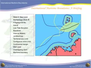
Ocean & Islands ProgrammeMaritime Boundaries Sector SPC SOPAC Division Notional PIC Maritime Zones & eCS Claim Areas – 2010 Baseline Survey 2010 eCS hydrographic survey 2010 eCS workshop 2010 Baseline Survey 2010 PIC maritime boundaries lodged in acordance with the provisions of UNCLOS as of Oct. 2010
Maritime Boundaries Establishment of maritime zones and boundaries (EEZ) in the Pacific Islands Region in accordance with the provisions of UNCLOS and development of extended continental shelf (eCS) claims. SPC SOPAC Division EEZ status unknown own arrangements eCS PICs with eCS potential EEZ 200nm Baseline ECS Delimitation FoS Baseline Delineation Contiguous Zone 24nm Territorial Sea 12nm 100 200 300
Maritime Boundaries Extended Continental Shelf Claims, so far. SPC SOPAC Division RMI FSM Palau Nauru Kiribati PNG Kiribati Kiribati Tuvalu Tokelau Solomon Is Samoa Vanuatu Cook Is. Niue Fiji Tonga 1.86million km2 presently under eCS claim.
Maritime Boundaries EEZ development SPC SOPAC Division
The challenge of developing enduring solutions to PIC maritime boundaries. SPC SOPAC Division • At this time only 3 PICs have declared their outer 200nautical mile zones and 4 have declared their archipelagic baselines. Less than half of the region’s shared boundaries are subject to treaty (21 of 48). • The development of maritime boundary solutions is a technical / legal / diplomatic process with multiple stakeholders – all components must equally interact to produce enduring solutions. • SOPAC and our technical partners (Geoscience Australia, Commonwealth Secretariat & UNEP GRID Arandal) have built excellent capacity in 8 PIC during our ECS work. It is our intension to continue to use these technical teams to progress boundaries development as well however these technical teams often lack legal and Govt. support. • Enduring boundary solutions must be developed in a way to serve multiple needs, not only fisheries management, e.g. security, biodiversity, conservation, research, deep sea minerals development, transport, vessel monitoring, support ECS claims, etc. • The 2010 Oceanscapes initiative raised issues regarding the possible threat to boundary baseline features through climate change stress and sealevel rise.
PIC baseline features - potential impact of climate changeFew PICs have declared their baselines or boundaries and there is considerable urgency to undertake this work due to present resource use and governance needs – the present work to characterise and declare boundaries is the best possible way of addressing such CC concerns. RMI Lowest Astronomical Tide = Baseline in many PICs SPC SOPAC Division FSM Palau Nauru Kiribati PNG Kiribati Kiribati Sea level rise Tuvalu Tokelau Solomon Is Samoa boundary Vanuatu Cook Is. Niue Fiji Tonga Baseline Precise determination & delimitation of maritime zones, EEZ, archipelagic status, shared boundaries & eCS, in accordance with UNCLOS. “New” Lowest Astronomical Tide & Baseline?? High tide Future low tide Low tide island reef Ocean and Islands Programme
SOPAC Division Responsibility Country Responsibility
The way ahead ………. SPC SOPAC Division • Recognise that successful boundary development is not just SOPAC’s responsibility – this process must be country lead. • The processes is technical, legal and diplomatic and is ultimately an issue of lasting sovereign importance. • This is not just a fisheries issue, each country has many potential stakeholders with an equal interest in boundary development and governance of marine resources. • Effective in-country progress requires a “multi-stakeholder” approach where all relevant parties have a clear understanding of the status, obstacles and requirements to progress towards baseline and boundary declaration. • The SPC SOPAC Division & technical partners welcomes FFA into the existing boundaries development partnership and the opportunities this brings. • A small boundaries team will be available throughout this week. If countries wish to meet to discuss the specific status of their maritime boundaries please come and talk to us - we can also arrange sit down meetings.
For more information email - arthur@sopac.org or arthurw@spc.int SPC SPC SPC Many thanks - any questions ……….. PIC extended continental shelf & maritime boundaries development teams & technical partners, Sydney 2010 Ocean and Islands Programme