Download
1 / 17
170 likes | 340 Vues
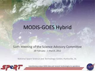
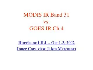
MODIS IR Band 31 vs. GOES IR Ch 4. Hurricane LILI -- Oct 1-3, 2002 Inner Core view (1 km Mercator). <- GOES. MODIS ->. Matching pairs of images MODIS IR vs GOES IR. Cloud top features are more clearly seen in the higher spatial resolution MODIS images, that are not well defined with GOES

E N D
MODIS IR Band 31 vs. GOES IR Ch 4 Hurricane LILI -- Oct 1-3, 2002 Inner Core view (1 km Mercator)
<- GOES MODIS ->
Matching pairs of images MODIS IR vs GOES IR • Cloud top features are more clearly seen in the higher spatial resolution MODIS images, that are not well defined with GOES • MODIS: 1 x 1 km FOV • GOES-8: 2.3 x 4 km FOV • Broader area differences in brightness temperatures are primarily due to image time differences
Matching pairs of images MODIS IR vs GOES IR • 0350 UTC / 1 Oct -- MODIS Terra • 0315 UTC / 1 Oct – GOES-8 IR • 1600 UTC / 1 Oct – MODIS Terra • 1545 UTC / 1 Oct – GOES-8 IR • 1905 UTC / 1 Oct – MODIS Aqua • 1915 UTC / 1 Oct – GOES-8 IR
Matching pairs of images MODIS IR vs GOES IR • 0715 UTC / 2 Oct -- MODIS Aqua • 0715 UTC / 2 Oct – GOES-8 IR • 1645 UTC / 2 Oct – MODIS Terra • 1645 UTC / 2 Oct – GOES-8 IR • 0755 UTC / 3 Oct – MODIS Aqua • 0745 UTC / 3 Oct – GOES-8 IR