Mapping and Management System for Flood Risk Map
280 likes | 463 Vues
Mapping and Management System for Flood Risk Map. China I nstitute of W ater Resources and H ydropower R esearch ( IWHR). By Li Changzhi. Toronto, Canada, May 6-8, 2008. Outline. Background Framework Functions Remarks. I. BACKGROUND. Why we develop this system?. I. Background.

Mapping and Management System for Flood Risk Map
E N D
Presentation Transcript
Mapping and Management System for Flood Risk Map ChinaInstitute of Water Resources and Hydropower Research (IWHR) By Li Changzhi Toronto, Canada, May 6-8, 2008
Outline • Background • Framework • Functions • Remarks
I. BACKGROUND Why we develop this system?
I. Background Flood risk mapping and management is important and urgent, but …? • Different type of data • ArcGIS, AutoCAD, MapInfo, MapGIS… • Different type of flood risk maps • Flood risk map for river (includes city) • Flood risk map for detention basin • Flood risk map for reservoir • Different base • Economic • Technical
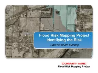
Harbin Chaersen Pangtoupao Lahai Danjiangkou Jingjiang Chengdu Guanshan Linanyuan Yiyang I. Background The Yangzte River Basin Pilot sites The Songliao River Basin City River Reservoir Detention basin
I. Background Harbin ArcGIS(*.shp) Chaersen MapGIS(*.wat) Pangtoupao AutoCAD(*.dwg,*.dxf) Laihai AutoCAD(*.dwg,*.dxf)
II. FRAMEWORK How we develop this system?
II. Framework of the platform 1 2 3 4 Hierarchy of the platform Special users Common users By IP Address or Server Name Guiding rule maker Map maker
II. Framework of the platform Main info in a flood risk map • General info • China’s National Fundamental Geographic Info • Structural measures info • Reservoirs, levees/dikes, detention basins… • Risk info • Scope of flooding • Depth of flooding • Velocity of flooding • Time of flood arrival • Duration of flooding • Risk-reduction info • Various info for flood risk reduction
II. Framework of the platform Standardization • Spatial data • Attribute data • Tables and their fields • Styles of layers
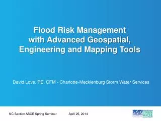
Development tool -- SuperMap GIS • Component GIS • Powerful data integration • Flexible architecture • Integrated assemblage • Core of GIS • General application software • Special industrial software • Internet-WEBGIS Special development GIS Core Application fields: land, military, water resources, environment …
III. FUNCTIONS What can we do using this system now?
Main function modules Some special functions All maps browsing In a detail map …
III. Functions of the system - Some special functions Vector data Raster data Integration of multi-sources data
III. Functions of the system - Some special functions Make a new flood risk map Name • Type • River/city • Detention basin • Reservoir Administrative area Sub-Basin • Info type • Fundamental • Structural info • Risk info • Risk reduction Datasources Available layers Selected layers
III. Functions of the system - In a detail map List of maps Legend List of layers In a detailed map display
III. Functions of the system - In a detail map Show/hide layers Fundamental info layers Flood risk info layers Structural measure info layers Risk reduction info layers
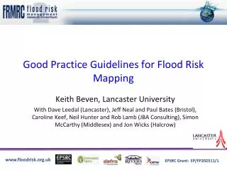
III. Functions of the system - In a detail map Flood standard Flooded area Affected people Affected property, Cities, railways, highways, etc.
III. Functions of the system - In a detail map Shelter Jiangwan town Water depth info Evacuation way
III. Functions of the system - In a detail map Flooded area Exposures Property Population Query the population and property in a flooded area
III. Functions of the system – Map view Map of water depth Map of flood arrival time Map of flooding duration Jingjiang Detention Basin
III. Functions of the system – Map view Map of water depth Map of flow velocity Map of flood arrival time Danjiangkou Reservoir
III. Functions of the system – Map view Waterloging in Chengdu city
IV. REMARKS What we learned from this work?
Specification – the base • Different management system – necessary • User’s needs – the driving force • Flood management • Landuse planning • Flood insurance • Flood risk popularization and education • Powerful GIS core – efficient tool • SuperMap Objects, SuperMap iServer
Thanks for your any suggestions or comments! Speaker: Li Changzhi Email: lichangzhi@iwhr.com Tel: 86-10-68781798 Affiliation:China Institute of Water Resources and Hydropower Research (IWHR)