Telecom Implementation
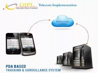
Telecom Implementation. Conceptual Diagram of PDA/ Mobile Application. 1. 3. 2. GEO Spatial Data Maintenance Using Mobile. Customized Query Builder & Analysis Report . User & Role Management. Total Solution. Connectivity. User (APCCF, CCF, DFO, RFO). WebGIS. Application Server.

Telecom Implementation
E N D
Presentation Transcript
Conceptual Diagram of PDA/ Mobile Application 1 3 2 GEO Spatial Data Maintenance Using Mobile Customized Query Builder & Analysis Report User & Role Management
Total Solution Connectivity User (APCCF, CCF, DFO, RFO) WebGIS Application Server Hosting GIS Server Content Authoring Database Server
Scope of PDA/Smart phone based Protection, Surveillance and Tracking System For Gujarat Forest Department • MIS Functionalities in PDA: • MIS functionality like Event Reporting, Registering of First Investigation Report, Passing of Vouchers, nursery operations will be handled by this application • GIS Functionalities in PDA: • Real time tracking of the Forest Beat security with position information such as the exact location, speed and the time. • Geo-coding of the locations / species if any along the trail of the route. • Ability to calculate the distance traveled and route between the two points. • Integrate with the Digital Maps of Forest (Presuming that GIS data is available). It shall be sole responsibility of GIPL / Gujarat Forest department to provide digital data. • Development of interface with GPRS network and Tetra network as appropriate. • Tracing the Location of each PDA that is in the field • Verifying of the location of Forest Boundary Pillars details along with their location. • Tracing / Location of Plantation and Nursery details. • Audit log of movement of personnel. • Interfacing to Gujarati and English. • User Access Control Management. • Interfacing to the MIS database. • Capturing and Uploading Polygon details, drainage lines, boundary lines etc. from PDA application to the Central server in the DC. • Processing the captured data from PDA, generating MIS reports, alerts, etc. • Query Tool. • OTAR
Screen Shots Fig 1 : Login Page Fig 2 : Menu Bar
Mobile GIS Application Map display Map Menu Zoom Out Zoom In
Command Control Room Application (Integrated Web Application) • Provision for the Over the Air Updates (OTAR) of the mobile application. • Command Control Room provides visibility of entire forest staff on single forest map. • Control room officer allocate and dispatch reinforcement in case of SOS Emergency. • GPS fitted in Windows mobile of forest staff collects his locations information and transmits it back to the Control room via GSM Network. • The communication system which is dispatcher operated should receive SOS from be forest staff, gather geographical and other details , identify proximate forest staff or re-enforcement, send instruction and generate reports based on queries. • Three types of communication mode needs to be implemented 1.Voice 2.Text 3. Email for SOS recording as well as forwarding. [contd.]
GIS data editing • Edit spatial and Non-spatial data with single window • Track the edits • Synchronize the data with MIS • Sketch tools for point, line and polygon
Thank You . . .