Exploration Profile of Grease River Uranium Property: High-Grade Mineralization Potential
100 likes | 232 Vues
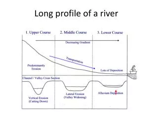
The Grease River Uranium Property encompasses 15 claims spanning 81,821 hectares on the Athabasca Basin's North rim. Geological assessments have revealed notable uranium mineralization, with over a dozen zones identified where mineral content surpassed 0.1% U3O8, reaching peaks of 55.06% U3O8. The Fall 2010 drilling program will focus on the Shearika Ridge zone, exhibiting similarities to Namibia's prolific Rössing deposit. The area promises significant exploration potential, backed by a partnership between WestCan Uranium Corp. and CanAlaska Uranium Ltd.

Exploration Profile of Grease River Uranium Property: High-Grade Mineralization Potential
E N D
Presentation Transcript
The Grease River property comprises 15 claims totaling 81,821 hectares and is located on the North rim of the Athabasca Basin Psammitic and pelitic gneisses are similar to the host rocks of all major Uranium deposits in the Athabasca Basin. Year round access by air and winter roads. Regional prospecting and airborne geophysical work demonstrated very high Uranium mineralization throughout the property. Significant Uranium - Thorium background was recognized along the contacts of major structural zones. Over a dozen zones identified where Uranium mineralization in boulders or outcrop exceeded 0.1% U3O8, and values in some zones exceeded 1% U3O8. Additional mapping and prospecting in 2008 produced samples that gave significant Uranium assays including 1.36% U3O8 and 1.28% U3O8 from higher grade vein zones. The highest analytical result encountered from surface sample analysis on the property was 55.06% U3O8. Sept. 2010 drill program planned to test the Shearika Ridge Uranium zone for a large tonnage intrusive hosted deposit. Grease River Uranium Property Two Areas targeted for Fall 2010 Drilling: Shearika Ridge - Occurrences show similarity to the famous Rössing deposit in Namibia, which has been mined continuously since 1976 and has produced a total of 215 million pounds of U3O8 to the end of 2009. Bradley Lake - Eight grab samples were collected by CanAlaska in 2008, and analyses ranged from 0.03% to 1.65% U3O8, with an average of 0.49% U3O8.
Grease River – Shearika Ridge Overview Aerial photo showing main Shearika Ridge uranium zone with higher grade core Shearika Ridge Uranium Zone Location • Marginal phases of granite intrusion with extensive Uranium mineralization. • Uranium occurs in pegmatitic granite sills. • Mineralization over a 3,000 metre by 300 metre area.
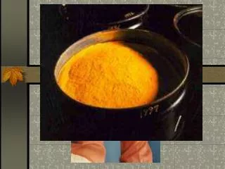
Grease River – Shearika Ridge Cont’d Yellow secondary Uranium minerals, Shearika Ridge Uranium mineralization in coarse-grained phase of granite, Shearika Ridge • Mineralization is similar to Rio Tinto’s famous Rössing deposit in Namibia.
Grease River – Bradley Lake • Intersecting strike-parallel shears and cross structures are favourable sites for unconformity-type uranium. • Psammiticand pelitic gneisses are similar to the host rocks of all the major uranium deposits in Athabasca Basin. • Mineralization consists of pitchblende filling fractures. • Pegmatite-type uranium is also present. • Bradley Shear is probably a basement-hosted unconformity-type uranium deposit. • High Grade, fracture hosted uranium may be related to sub-Athabasca unconformity. Bradley Lake Location
Fracture hosted Uranium • 12,000 cps in fractures crosscutting • Pegmatite. Location: Bradley Uranium Zone Musc in pegmatite. 6,000 cps bagged +15,000 cps in O/C Location: Bradley Uranium Zone
Pegmatite Pegmatite METASEDIMENTS Location: Bradley Uranium Zone U-staining - 300 cps in pegmatite Location: Bradley Uranium Zone
Conclusion Summary: • Joint venture between WestCan Uranium Corp. and CanAlaska Uranium Ltd. • High probability of a a large tonnage intrusive hosted Uranium deposit. • The expansion of nuclear power in countries like Korea and the UAE will increase demand for Uranium and investment in Uranium Companies in 2010 and beyond. • Highly experienced management and Geological team in place guide projects success. Program Timeline: • Fall 2010 - mapping Shearika Ridge • Winter 2010/2011 - First phase of drilling, Shearika Ridge • 1,000 metres of drilling will determine economic potential of Shearika Ridge • Fall 2010 - mapping Bradley Zone