Download
1 / 32
320 likes | 366 Vues
Learn about air masses, frontal boundaries, and their effects on wind patterns. Understand the formation of warm and cold fronts and how they contribute to different types of precipitation. Explore the development and impact of severe thunderstorms, tornadoes, and hurricanes.

E N D
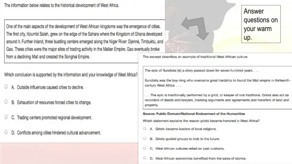
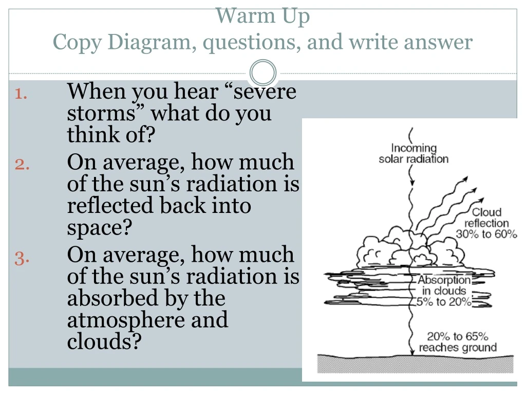
Warm UpCopy Diagram, questions, and write answer When you hear “severe storms” what do you think of? On average, how much of the sun’s radiation is reflected back into space? On average, how much of the sun’s radiation is absorbed by the atmosphere and clouds?
Weather Patterns and Severe Storms 2.5.2b Explain how interactions of air masses form frontal boundaries, clouds, and affect wind patterns.2.5.3a Explain factors that affect air density and understand their influence on winds, air masses, fronts and storm systems.
Before we begin… Watch as we draw the isotherms on the map. Remember, ISO means the “same”
Objectives • Today I will be able to: • Describe the factors that characterize air masses • Analyze the development of fronts when air masses meet • Relate severe weather to the interaction of air masses
Key Points Air masses are characterized by their temperature and moisture Air masses take on the characteristics of the land/water they pass over When air masses meet a front is formed and warm air is always forced upward Warm fronts bring longer lasting, gentle precipitation Cold fronts bring heavy, but short lived precipitation
Air Masses and Weather Weather patterns result from the movement of large bodies of air called air masses Air masses are characterized by similar temperatures and amounts of moisture at certain altitudes. When air masses move, the characteristics of the air mass change and the weather in the areas over which they move changes
Starts off at -460C Ends up at 700C
Air Masses and Weather • Example of air mass/weather interaction: • A cold, dry air mass moves over warm, tropical waters • The air mass becomes warmer and wetter • The weather over those waters becomes colder and drier You try… • A warm, dry air mass moves over a cold, wet area • The air mass becomes ______________ and _______ • The weather over that area becomes ____________ and ____________
When air masses meet… Fronts • When two air masses meet, they form a front- the boundary that separates the two • There are 4 types of fronts • Warm fronts • Cold fronts • Stationary fronts • Occluded fronts
Fronts • Warm fronts • Form when warm air moves into an area formerly covered by cold air • Shown on a weather map by a red line with semi-circles pointing toward the colder air Warmer air Colder air
Fronts Warm front
Fronts • Warm fronts • As the warmer, less dense air rises, it cools • This produces clouds and frequent precipitation • Warm fronts move slowly, so the precipitation is light-to-moderate over a large area for a long period of time
Fronts • Cold fronts • Form when cold, dense air moves into an area formerly occupied by warmer air • Shown on a weather map by a blue line with triangles pointing toward the warmer air Colder air Warmer air
Fronts Cold Front
Fronts • Cold Fronts • Move much more quickly than warm fronts • Associated with heavy precipitation that is short-lived
Fronts • Stationary Fronts • Form when the flow of air is neither toward the cold air mass, nor toward the warm air mass • The front does not move • Shown by blue triangles on one side and red semicircles on the other • Gentle to moderate precipitation
Fronts • Occluded Front • Forms when a cold front overtakes a warm front • Complex weather patterns
Finish worksheet, then answer questions A cold, dry air mass that moves over warm, tropical waters will likely become ____and _______. Along which type of front is the intensity of precipitation generally heavy, but short-lived? Along a front, which type of air is always forced upwards?
Severe Storms • Thunderstorms • Develop when warm, humid air rises in an unstable environment Warm air Heavy rain Cooler air
Severe Storms • Tornadoes • Violent windstorms • Form as a vortex extends down from a cumulonimbus cloud • A vortex is a rotating column of air • Most tornadoes form along with severe thunderstorms
Severe Storms • Tornadoes • Tornado Watches: there is the possibility of a tornado in the area • Tornado Warning: a tornado has been spotted in the area or is indicated by radar
Damage Caused by Tornadoes Extremely high winds can tear buildings apart, slip cars, and even suck the water out of a riverbed
Severe Storms • Hurricanes • A hurricane is a large, rotating tropical weather system with wind speeds of at least 74 mph • Hurricanes are the most powerful storms on Earth • In other countries they are also known as typhoons and cyclones • http://www.wral.com/weather/hurricanes/story/3311088/ • http://www.wral.com/weather/hurricanes/video/9924105/
How Do Hurricanes Form? • A hurricane begins as a group of thunderstorms moving over tropical ocean waters • Winds traveling in two different directions collide causing the storm to spin • Warm water gives the storm energy and causes it to grow
Structure of a Hurricane Theeye wallis a doughnut-shaped area of intense cumulonimbus development and very strong winds that surrounds the eye of a hurricane. The eyeis a zone of scattered clouds and calm averaging about 20 kilometers in diameter at the center of a hurricane. The eye has the warmest temperatures.
Damage Caused by Hurricanes • Hurricane winds can knock down trees and telephone poles • However, the most damage during a hurricane comes from flooding due to heavy rain and storm surges • A storm surge is a wall of water that builds up over the ocean and can be up to 20 feet before it crashes onto the shore
WARM UP 5/11/10 The boundary that separates different air masses is called _____ What is the most abundant gas in the atmosphere? What is the most important gas for understanding atmospheric processes? Air that has reached its water vapor capacity is ____________. What type of winds are produced by steep pressure gradients?
FRONT ACTIVITY • You will be completing this activity in groups • For each of the pressure systems and fronts: • Draw the symbol • Explain the effect these have on weather
YOU BE THE METEOROLOGIST TODAY-Lots of clouds, a stiff northeast wind, and periods of rain will make for a chilly and wet day. Highs will struggle to reach the upper 50s here in the Triangle, but low 60s are very possible south and east of Raleigh. SATURDAY-Happy Halloween! No spooky weather is expected at this time. Expect mostly sunny to partly cloudy skies and slightly milder temperatures with highs in the mid to upper 60s. The evening looks nice for trick or treaters, and remember that later tonight we "fall back" to standard time.
YOU BE THE METEOROLOGIST Pretend that you are a meteorologist for Apex, NC. Write a script for you to read during the news describing the fronts and weather patterns Apex has experienced over the past 7 days. Your script should be at least 7 sentences long and be accurate. EXAMPLE: On Sunday, Apex experienced a High pressure system causing the weather to be clear and sunny, with highs in the upper 80’s. Note: exact temperatures may be made up.
Raging Planet - Hurricanesas you watch, write at least 5 pieces of info for each of the following categories. Your paper should look like this HOW HURRICANES FORM 1. 2. 3. 4. 5. TOOLS AND TECHNIQUES FOR PREDICTING HURRICANES 1. 2. 3. 4. 5.
EXIT TICKET What type of front is drawn as a line with semi-circles extending out? True or false?- In a cold front the symbols on the front line point toward the cold air. What type of front is associated with heavy, short-lived precipitation? High pressure systems are associated with what weather conditions?