Download
1 / 7
70 likes | 151 Vues
Comprehensive analysis of Atlantic hurricane track models from 2004-2008. Comparison of forecast skill and verification results. Use of key predictors like SST Potential, Wind Shear, and more for model accuracy assessment.

E N D
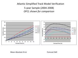
Atlantic Simplified Track Model Verification5-year Sample (2004-2008)OFCL shown for comparison Mean Absolute Error Forecast Skill
Dynamical Model* Skill (Early Versions) Atlantic Sample 2004-2008 *HWFI excluded due to sample size limitations
Operational Atlantic Early Intensity Model Verification5-year Sample (2004-2008) OFCL shown for comparison Mean Absolute Error Forecast Skill *HWRF, LGEM, consensus models excluded due to sample size restrictions
The SHIPS Model Predictors* *Red text indicates most important predictors (+) SST POTENTIAL (VMAX-V): Difference between the maximum potential intensity (depends on SST) and the current intensity. (-) VERTICAL (850-200 MB) WIND SHEAR: Current and forecast, impact modified by shear direction (+) PERSISTENCE: If it has been strengthening, it will probably continue to strengthen, and vice versa. (-) UPPER LEVEL (200 MB) TEMPERATURE: Warm upper-level temperatures inhibit convection (+) THETA-E EXCESS: Related to buoyancy (CAPE); more buoyancy is conducive to strengthening (+) 500-300 MB LAYER AVERAGE RELATIVE HUMIDITY: Dry air at mid-levels inhibits strengthening
The SHIPS Model Predictors (Cont…) • (+) 850 MB ENVIRONMENTAL RELATIVE VORTICITY: Vorticity averaged over large area (r <1000 km). Intensification is favored when the storm is in an environment of cyclonic low-level vorticity. • (+) GFS VORTEX TENDENCY: 850 hPa tangential wind (0-500 km radial average). Intensification favored when GFS spins up storm. • (-) ZONAL STORM MOTION: Intensification is favored when TCs are moving west • (-) STEERING LAYER PRESSURE: intensification is favored for storms that are moving more with the upper level flow. This predictor usually only comes into play when storms get sheared off and move with the flow at very low levels (in which case they are likely to weaken). • (+) 200 MB DIVERGENCE: Divergence aloft enhances outflow and promotes strengthening • (-) CLIMATOLOGY: Number of days from the climatological peak of the hurricane season
Factors in the Decay-SHIPS ModelCenter over Water Normalized Regression Coefficients at 48 hr for 2009 SHIPS Model