Download
1 / 7
70 likes | 161 Vues
Streamline your environmental monitoring with DEM mosaic creation, slope calculation, Landsat image registration, NDVI classification, land use analysis, soil mapping, and HUCEPI erosion potential modeling using ArcGIS and ENVI.

E N D
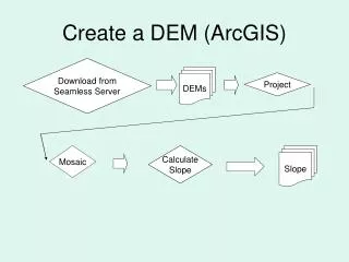
Create a DEM (ArcGIS) Download from Seamless Server DEMs Project Mosaic Calculate Slope Slope
Download & Register Imagery (ENVI) Correct To reflection Landsat 5 Stack Register L7 to L5 Download Stack Correct To reflection Landsat 7
Assign NDVI Classes (ENVI) Water Classification L 5 Land Classification NDVI Low Weight all NDVI Values NDVI Classification NDVI Med NDVI Hi Do the same for L7 image!
Classify Image for Land Use (ENVI) L 5 Agric Fallow Land Use Classification Streams & Rivers Roads Weight all LU Classifications Urban Lakes & Ponds Wetlands Forest, Shrub, Grass Agric Active Do the same for L7 image!
Download & Project Soil Classes (ArcGIS) Download from USDA Server Soils Project
Download & Project Rivers, Basins, HUCs (ArcGIS) Rivers & Basins Download from USDA Server Project Calculate Stream Lengths Calculate HUC Areas Categorize by HUC
HUC Erosion Potential Index (HUCEPI) Model (ArcGIS) HUC Area HUCEPI Slope NDVI Land Use Soil X X X X = HUC Stream Length