Download
1 / 76
810 likes | 1.04k Vues
The Geography of the United States. By: Ms. Susan M. Pojer Horace Greeley HS Chappaqua, NY Adapted By: Mr. Dennis Sugrue & Mrs. Melissa Sisco. US Geography Basics. Third largest country in the world. Half the size of Russia. One third the size of Africa.

E N D
The Geography of the United States By: Ms. Susan M. PojerHorace Greeley HS Chappaqua, NY Adapted By: Mr. Dennis Sugrue & Mrs. Melissa Sisco
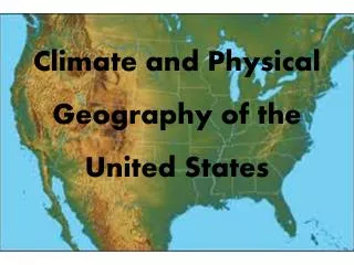
US Geography Basics • Third largest country in the world. • Half the size of Russia. • One third the size of Africa. • Half the size of South America. • 2 ½ times the size of Western Europe.
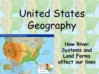
United States Geography We will learn: 1. What maps tell us 2. The location of all the states 3. The location of major bodies of water 4. The location of major topography 5. The major regions
Label as many states as you can:
JAMESTOWN vs PLYMOUTH QUESTION: How were the locations of these early settlements similar? How might geography have affected the development of these two settlements? Label and Date Jamestown and Plymouth.
Label the early regions of the English colonies: 1. Southern 2. Middle 3. New England
ORIGINAL 13 COLONIES QUESTIONS What do you think the purpose of the Proclamation of 1763 was? What physical feature (not shown on this map) may have helped enforce the Proclamation? What were the northern most/ southern most colonies?
Territorial Expansion Which geographic feature was the boundary between the US in 1783 and the Louisiana Purchase? If the Great Plains were shown in this map, where would they mostly be located?
Topography of the US What type of map is this?
New York’s Canals QUESTION: What was the importance of these early canals? Label the Erie Canal and Hudson.
A New England Fall The back roadsof Vermont Kancamagus Highway, Maine Covered Bridge over the Connecticut River
North-South Divide: The Mason-Dixon Line Charles Mason & Jeremiah Dixon: 1763-1767
The Great Plains What Americans first explored this region? Who was move into this region in the 1830s and 40s? What natural disaster happened in this region in the 1930s?
How did these many rivers impact the development of America?
Name all the major bodies • of water: • Atlantic Ocean • Pacific Ocean • Mississippi River • Hudson River • St. Lawrence River • Ohio River • Erie Canal • Great Lakes • Missouri River • Colorado River • Rio Grande • Chesapeake Bay
Bodies of Water Great Lakes Great Salt Lake Chesapeake Bay
Rivers St. Lawrence R. Columbia R. Hudson R. Missouri R. Potomac R. Mississippi R. Ohio R. Colorado R. Arkansas R. Rio Grande R. Yukon R.
The Mississippi: America’s Great River Road • The “Big Muddy”. • Part of Louisiana Purchase 1803 w/ Port of N.O. • 2,350 miles. • Draining all or part of 31 states & 2 Canadian provinces. • Covers 40% of the U. S.
Label all the major mountain • ranges: • Appalachian Mountains • Rocky Mountains • Sierra Nevada • Great Plains
Mountains & Plateaus Adirondack Mts. Cascade Mts. Rocky Mts. Great Plains Appalachian Mts. Sierra Nevada Mts. ^ Mt. Whitney ^ Pike’s Peak ^ Mt. McKinley Alaskan Range
Plains GreatBasin Central Plains Atlantic Coastal Plains Gulf Coastal Plains