HURRICANES – NATURE’S FURY!!!
220 likes | 395 Vues
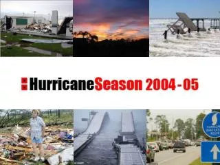
HURRICANES – NATURE’S FURY!!!. Check these out…. You’d probably want to evacuate at this point…. What kind of damage are we talkin’ about here?. Might want to take the detour…. Ok, So What Exactly Is a Hurricane?.

HURRICANES – NATURE’S FURY!!!
E N D
Presentation Transcript
Check these out… You’d probably want to evacuate at this point…
What kind of damage are we talkin’ about here? Might want to take the detour…
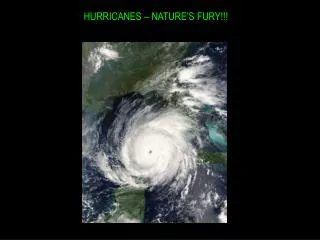
Ok, So What Exactly Is a Hurricane? A hurricane can best be described as a huge tropical storm (up to 600 miles in diameter)! Winds can be up to 200 mph! Storms usually doesn’t last for more than 7-10 days. It moves across the ocean at around 10-20 mph…not too fast really! Arrows indicate “feeder bands” or “rain bands” The winds are the strongest around the eye wall. The eye of the storm is usually about 20 miles in diameter. Within the eye, winds are calm and the weather is great. Strongest winds are on the right side, heaviest rain is usually on the left side.
Scary…so when do I need to watch out for these things?? Since we’re in the USA, we’ll focus on what meteorologists call the “Atlantic Basin”. The Atlantic basin includes the Atlantic Ocean, Caribbean Sea, and the Gulf of Mexico. The “hurricane season” is just a name for the time period when we expect to see tropical systems develop. The hurricane season for the Atlantic runs from June 1st – November 30th. Peak season is the middle part of September…why do you think this is?
So where are these “Atlantic Basin” Hurricanes forming??? Storms of the Atlantic basin will begin forming in one of three places: • Off the coast of Africa • In the Caribbean Sea • In the Gulf of Mexico What is the ITCZ????
Intertropical Convergence Zone The ITCZ is an area of low pressure located roughly 5 degrees North and South of the Equator. It is a place where air converges, rises, and condenses (forming clouds). It is the rainiest place on Earth!
What Does a Hurricane Need in Order to Develop? A hurricane needs warm water, time to grow, and favorable upper level winds in the troposphere. If the winds are too strong, they will blow the hurricane apart – we call that wind shear!
Evolution of Hurricane Development -- Stages Stage 1 – Tropical Depression(Wave) Usually has begun its life off of the west coast of Africa in the ITCZ. Tropical depressions have winds of less than 39mph, and are not given a name. Lacks structure – no well developed feeder bands or eye
Evolution of Hurricane Development -- Stages Stage 2 – Tropical Storm At this point, the tropical storm is beginning to develop some serious structure. Winds range from 40-73 mph. In the Atlantic, storms are given a name when they reach this stage. Feeder bands are beginning to develop – you can see the center of the low pressure system more easily. Eye and eye wall still not well formed.
Evolution of Hurricane Development -- Stages Stage 3 – Category 1 Hurricane Winds range from 75-94 mph. Well developed feeder bands. An eye begins to form (although it is covered in clouds). Storm is tightening around center.
Evolution of Hurricane Development -- Stages Stage 4 – Category 2 Hurricane Winds range from 95-110 mph. Well developed feeder bands. An eye and eye wall are usually very well formed. Storm continues to tighten around center.
Evolution of Hurricane Development -- Stages Stage 5 – Category 3 Hurricane Winds range from 111-130 mph. Now considered a “Major Storm”. Intense flooding and building damage will occur to most areas on the coast. Further inland, the damage will still be substantial.
Evolution of Hurricane Development -- Stages Stage 6 – Category 4 Hurricane Winds range from 131-155 mph. Shrubs, signs and trees can be blown down. COMPLETE DESTRUCTION of mobile homes is possible. Extensive damage to doors and windows. Major damage to lower floors of structures near the coast.
Evolution of Hurricane Development -- Stages Stage 7 – Category 5 Hurricane Winds greater than 156 mph! Complete roof failure on many residential and industrial buildings. Some complete building failures with small utility buildings blown over or away. Massive evacuation of residential areas on low ground within 5-10 miles of the coastline maybe required.
Hurricane Naming System – Why do they have names anyway? AndreaBarryChantalDeanErinFelixGabrielleHumbertoIngridJerryKarenLorenzoMelissaNoelOlgaPabloRebekahSebastienTanyaVanWendy • In 1953 the National Weather Service began naming storms after women. • In 1979, men’s names were added to the list of hurricane names. • In the Atlantic, there are 6 lists of names that are recycled. • In the case of storms so devastating that reusing the name is inappropriate, the name is taken off the list and another name is used to replace it. The name “Katrina” is one that will be removed from the list. Example LIST: