Download
1 / 7
70 likes | 154 Vues
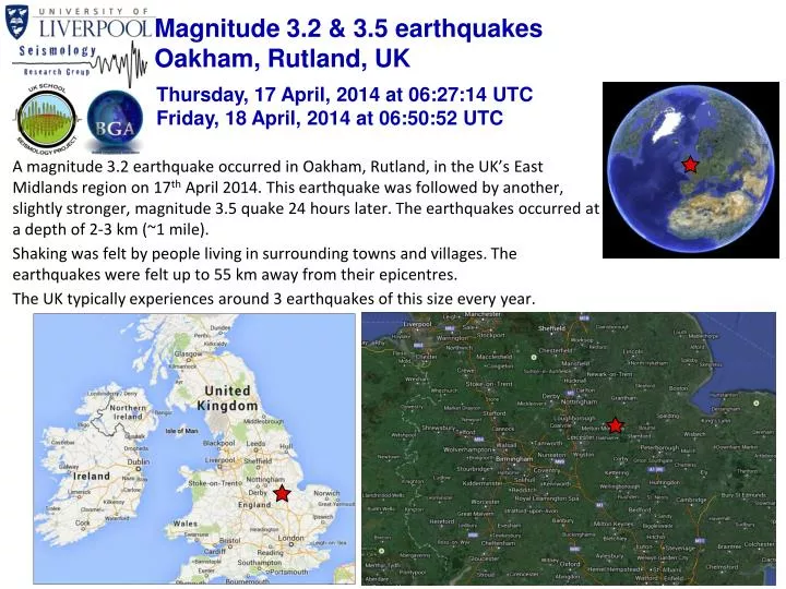
Magnitude 3.2 & 3.5 earthquakes Oakham, Rutland, UK. Thursday, 17 April, 2014 at 06:27:14 UTC Friday, 18 April, 2014 at 06:50:52 UTC.

E N D
Magnitude 3.2 & 3.5 earthquakes Oakham, Rutland, UK Thursday, 17 April, 2014 at 06:27:14 UTC Friday, 18 April, 2014 at 06:50:52 UTC • A magnitude 3.2 earthquake occurred in Oakham, Rutland, in the UK’s East Midlands region on 17th April 2014. This earthquake was followed by another, slightly stronger, magnitude 3.5 quake 24 hours later. The earthquakes occurred at a depth of 2-3 km (~1 mile). • Shaking was felt by people living in surrounding towns and villages. The earthquakes were felt up to 55 km away from their epicentres. • The UK typically experiences around 3 earthquakes of this size every year.
Magnitude 3.2 & 3.5 Oakham, Rutland, UK Thursday, 17 April, 2014 at 06:27:14 UTC Friday, 18 April, 2014 at 06:50:52 UTC Where was the earthquake felt? Most shaking was felt within a 30 km radius of the earthquakes’ epicentre. The furthest felt reports came from Mansfield to the northwest and Wellingborough to the south (45 – 55 km away). The strongest recorded felt intensity was IV(moderate shaking). The M3.5 earthquake on 18/04 had more felt reports than the 3.2 quake, especially north of the epicentre. This is probably due to the second earthquake’s slightly larger magnitude. M3.2 earthquake 17/04 M3.5 earthquake 18/04 Location of shaking reports (image courtesy BGS) Modified Mercalli Intensity Scale
Magnitude 3.2 & 3.5 Oakham, Rutland, UK Thursday, 17 April, 2014 at 06:27:14 UTC Friday, 18 April, 2014 at 06:50:52 UTC Past earthquakes in the region Small earthquakes in this part of the UK are not unusual. The largest recorded earthquake in this region of was a magnitude 4.1 event that occurred near Melton Mowbray in October 2001 (20km NW of the 2014 quakes). The largest recorded earthquake in the East Midlands region was a magnitude 5.2 earthquake near Market Rasen on February 2008 (80 km NW of the 2014 quakes). M5.2 Market Rasen earthquake, 2008 Possible mining-induced earthquakes M4.1 Melton Mowbray earthquake, 2001 Historic seismicity (since 1970) recorded in the region. The earthquake epicentre is indicated by the red star. Earthquake locations from the BGS catalogue.
Magnitude 3.2 & 3.5 Oakham, Rutland, UK Thursday, 17 April, 2014 at 06:27:14 UTC Friday, 18 April, 2014 at 06:50:52 UTC What caused these earthquakes to occur? The UK does not lie on an active tectonic plate boundary (one of its nearest plate boundaries is the Mid-Atlantic Ridge – located some 2000 km to the west). However, the stresses from these plate boundaries can be transferred to the middle of the plates. This stress is sometimes released along pre-existing faults within the crust of the Eurasian tectonic plate. Earthquakes in the UK can also be caused by gradual uplift of the crust since the last ice age. Many of the UK’s ancient faults are not seen on the surface – these are known as‘blind faults’. The lack of earthquakes in the UK also means we are unable to identify every fault in the UK that could cause an earthquake. N. American plate Eurasian plate Alpine – Pyrenees mountain belt Mid-Atlantic Ridge Africa – Eurasia collision zone Map of major tectonic boundaries in Western Europe
Magnitude 3.2 & 3.5 Oakham, Rutland, UK Thursday, 17 April, 2014 at 06:27:14 UTC Friday, 18 April, 2014 at 06:50:52 UTC Recordings of the earthquake from the British Geological Survey seismometer network By finding the difference in arrival times between the P- and S-wave arrivals at different seismic stations, we can calculate the distance of the earthquake from each receiver (circles). If we do this for several stations (triangles), we can determine the approximate epicentre of the earthquake (red star) by finding the common intersection point of these circles. Seismic recordings of the 17 April M3.2 earthquake P-wave S-wave
Magnitude 3.2 & 3.5 Oakham, Rutland, UK Thursday, 17 April, 2014 at 06:27:14 UTC Friday, 18 April, 2014 at 06:50:52 UTC Recordings of the earthquake from the British Geological Survey seismometer network By finding the difference in arrival times between the P- and S-wave arrivals at different seismic stations, we can calculate the distance of the earthquake from each receiver (circles). If we do this for several stations (triangles), we can determine the approximate epicentre of the earthquake (red star) by finding the common intersection point of these circles. Seismic recordings of the 18 April M3.5 earthquake P-wave S-wave
Magnitude 3.2 & 3.5 Oakham, Rutland, UK Thursday, 17 April, 2014 at 06:27:14 UTC Friday, 18 April, 2014 at 06:50:52 UTC Find out more … • BGS webpages for these earthquakes http://earthquakes.bgs.ac.uk/earthquakes/recent_events/20140417060453.html and http://earthquakes.bgs.ac.uk/earthquakes/recent_events/20140418065001.html • BGS (British Geological Survey) – seismology and earthquakes – frequently asked questions http://www.earthquakes.bgs.ac.uk/education/faqs/faq_index.html • IRIS (Incorporated Research Institutions for Seismology) – learning about earthquakes http://www.iris.edu/hq/programs/education_and_outreach/students • UK School Seismology Project – classroom activities, videos and support documents http://www.bgs.ac.uk/schoolseismology/home.html • USGS (United States Geological Survey) – FAQs, glossary, posters, animations http://earthquake.usgs.gov/learn/ • EMSC (European Mediterranean Seismological Centre) http://www.emsc-csem.org/