Download
1 / 20
200 likes | 324 Vues
This study presents the configuration and capabilities of a quasi-global ROMS (Regional Ocean Modeling System) aimed at improving understanding of ocean dynamics and climatic impacts. Featuring a zonal resolution of 0.8º and a meridional resolution varying between 0.3 to 0.7º, the model simulates ocean currents and critical climatic indexes such as the PDO and Nino3.4. Key applications include water mass studies in the Pacific, sea level assessments in San Francisco, and interlinking with atmospheric models for comprehensive climate analysis. Future improvements are also outlined for enhanced realism.

E N D
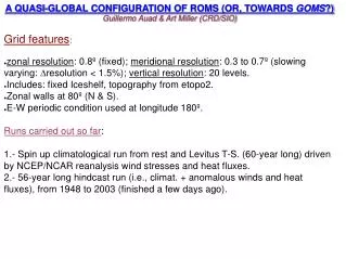
A QUASI-GLOBAL CONFIGURATION OF ROMS (OR, TOWARDS GOMS?) Guillermo Auad & Art Miller (CRD/SIO) Grid features: • zonal resolution: 0.8º (fixed); meridional resolution: 0.3 to 0.7º (slowing varying: ∆resolution < 1.5%); vertical resolution: 20 levels. • Includes: fixed Iceshelf, topography from etopo2. • Zonal walls at 80º (N & S). • E-W periodic condition used at longitude 180º. Runs carried out so far: 1.- Spin up climatological run from rest and Levitus T-S. (60-year long) driven by NCEP/NCAR reanalysis wind stresses and heat fluxes. 2.- 56-year long hindcast run (i.e., climat. + anomalous winds and heat fluxes), from 1948 to 2003 (finished a few days ago).
A minor code adaptation Spin up of the model's total kinetic energy Model output: main ocean currents of the World A tough test: coastal flows A tougher test: representation of a water mass: NPIW 2 climatic indexes in the Pacific Ocean: PDO and Nino3.4 Planned applications Organization
Scaling of horizontal viscosity coefficient goal: for each grid cell to proportionally (to its grid size) contribute potential vorticity to western boundary layers. ß ψx ~ Ahψxxxx(1) but since Ah needs to satisfy a minimum value in order to yield realistic solutions (Bryan, Manabe and Pacanowski, 1975): Ah> 0.17 * ß* dx³ (2) from (1) and (2) we can scale Ah as Ah~ Ah0 (dx/dx0)**3 cos(φ)cos(φ0) (3) where the subindex 0 marks the latitude, and viscosity of the largest grid size in the domain (dx0). In practice: Obtain Ah0 from (2) (i.e., for the largest grid size), and then obtain the rest using (3).
Minimum Viscosity Coeff. (visc2) vs. Latitude Ah=Ah(φ,dx)
Gulf Stream, Antilles Curr., Loop Current & Labrador Curr. MGSVA ROMS
Malvinas-Brasil Confluence Area summer winter from MGSVA
Across-equator zonal velocity profiles (152°W – Hawaii-Tahiti transect) From Johnson & Luther (1994) - current meter data ROMS
150 m Winter Flows off California Surface
STRAIT OF GIBRALTAR Mean speed from obs (ADCP) Mean speed from ROMS
TRANSPORT THROUGH DRAKE PASSAGE Malvinas Various ACDP estimates from the Univ. of Southampton=94Sv-155Sv ROMS: 128 Sv Whitworth & Peterson (1985)(*)=134 13Sv
(from L. Talley, SIO) Global ROMS Global Salinity Minimum Water Masses: today the NPIW
CLIMATIC INDEXES FROM 56-y RUN: PDO and NIÑO3.4 Corr=0.67; Coherence for 25y harmonic: 0.91 (10° phase) Corr=0.73; Coherence for 4y harmonic=0.78 (ampl=0.7 & phase =7°)
Planned Applications of the Global ROMS Couple “GOMS” to an atmospheric model (ECPC fcsts) Use its output (climat & hincdast) as OBCs in regional models (a few latin american scientists are interested in this) Sea level (*)& climatic studies. Studies on water mass formation (NPIW and Ross Sea area) Future runs/planned improvements: Filter forcing with Killworth's matrix to obtain more realistic amplitudes (*) (e.g., Nino3.4 index). Include sea-ice. (*) underway