Download
1 / 1
10 likes | 131 Vues
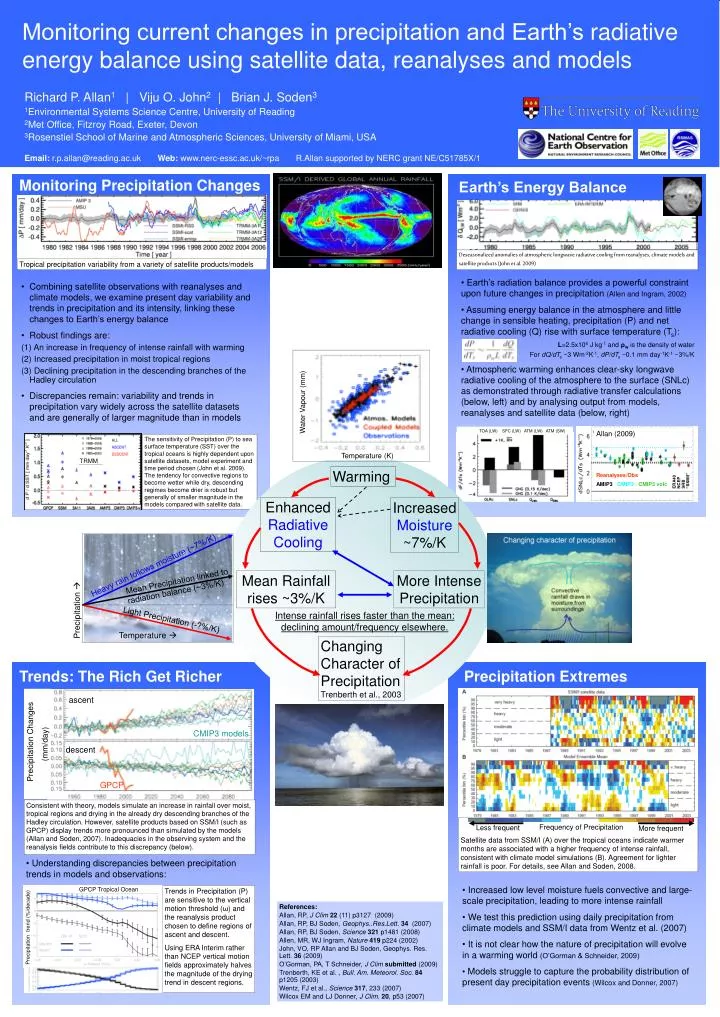
Water Vapour (mm). Temperature (K). Warming. Enhanced Radiative Cooling. Increased Moisture ~7%/K. Mean Rainfall rises ~3%/K. More Intense Precipitation. Intense rainfall rises faster than the mean: declining amount/frequency elsewhere.

E N D
Water Vapour (mm) Temperature (K) Warming Enhanced Radiative Cooling Increased Moisture ~7%/K Mean Rainfall rises ~3%/K More Intense Precipitation Intense rainfall rises faster than the mean: declining amount/frequency elsewhere. Changing Character of Precipitation Trenberth et al., 2003 Heavy rain follows moisture (~7%/K) Mean Precipitation linked to radiation balance (~3%/K) ascent Precipitation Light Precipitation (-?%/K) CMIP3 models Precipitation Changes (mm/day) Temperature descent GPCP Consistent with theory, models simulate an increase in rainfall over moist, tropical regions and drying in the already dry descending branches of the Hadley circulation. However, satellite products based on SSM/I (such as GPCP) display trends more pronounced than simulated by the models (Allan and Soden, 2007). Inadequacies in the observing system and the reanalysis fields contribute to this discrepancy (below). Satellite data from SSM/I (A) over the tropical oceans indicate warmer months are associated with a higher frequency of intense rainfall, consistent with climate model simulations (B). Agreement for lighter rainfall is poor. For details, see Allan and Soden, 2008. Frequency of Precipitation Less frequent More frequent Monitoring current changes in precipitation and Earth’s radiative energy balance using satellite data, reanalyses and models Richard P. Allan1 | Viju O. John2 | Brian J. Soden3 1Environmental Systems Science Centre, University of Reading 2Met Office, Fitzroy Road, Exeter, Devon 3Rosenstiel School of Marine and Atmospheric Sciences, University of Miami, USA Email:r.p.allan@reading.ac.ukWeb:www.nerc-essc.ac.uk/~rpaR.Allan supported by NERC grant NE/C51785X/1 Monitoring Precipitation Changes Earth’s Energy Balance Deseasonalized anomalies of atmospheric longwave radiative cooling from reanalyses, climate models and satellite products (John et al. 2009) Tropical precipitation variability from a variety of satellite products/models • Earth’s radiation balance provides a powerful constraint upon future changes in precipitation (Allen and Ingram, 2002) • Assuming energy balance in the atmosphere and little change in sensible heating, precipitation (P) and net radiative cooling (Q) rise with surface temperature (Ts): • L=2.5x10⁶ J kg-1 and ρw is the density of water • For dQ/dTs ~3 Wm-2K-1, dP/dTs ~0.1 mm day-1K-1 ~3%/K • Atmospheric warming enhances clear-sky longwave radiative cooling of the atmosphere to the surface (SNLc) as demonstrated through radiative transfer calculations (below, left) and by analysing output from models, reanalyses and satellite data (below, right) • Combining satellite observations with reanalyses and climate models, we examine present day variability and trends in precipitation and its intensity, linking these changes to Earth’s energy balance • Robust findings are: • An increase in frequency of intense rainfall with warming • Increased precipitation in moist tropical regions • Declining precipitation in the descending branches of the Hadley circulation • Discrepancies remain: variability and trends in precipitation vary widely across the satellite datasets and are generally of larger magnitude than in models TOA (LW) SFC (LW) ATM (LW) ATM (SW) Allan (2009) The sensitivity of Precipitation (P) to sea surface temperature (SST) over the tropical oceans is highly dependent upon satellite datasets, model experiment and time period chosen (John et al. 2009). The tendency for convective regions to become wetter while dry, descending regimes become drier is robust but generally of smaller magnitude in the models compared with satellite data. TRMM ERA40 NCEP SRB “SSM/I” Reanalyses/Obs AMIP3CMIP3CMIP3 volc Trends: The Rich Get Richer Precipitation Extremes • Understanding discrepancies between precipitation trends in models and observations: • Increased low level moisture fuels convective and large-scale precipitation, leading to more intense rainfall • We test this prediction using daily precipitation from climate models and SSM/I data from Wentz et al. (2007) • It is not clear how the nature of precipitation will evolve in a warming world(O’Gorman & Schneider, 2009) • Models struggle to capture the probability distribution of present day precipitation events(Wilcox and Donner, 2007) GPCP Tropical Ocean Trends in Precipitation (P) are sensitive to the vertical motion threshold (ω) and the reanalysis product chosen to define regions of ascent and descent. Using ERA Interim rather than NCEP vertical motion fields approximately halves the magnitude of the drying trend in descent regions. References: Allan, RP, J Clim22 (11) p3127 (2009) Allan, RP, BJ Soden, Geophys..Res.Lett. 34 (2007) Allan, RP, BJ Soden, Science321 p1481 (2008) Allen, MR, WJ Ingram, Nature419 p224 (2002) John, VO, RP Allan and BJ Soden, Geophys. Res. Lett. 36 (2009) O’Gorman, PA, T Schneider, J Climsubmitted (2009) Trenberth, KE et al. , Bull. Am. Meteorol. Soc.84 p1205 (2003) Wentz, FJ et al., Science317, 233 (2007) Wilcox EM and LJ Donner, J Clim.20, p53 (2007) Precipitation trend (%/decade)