Download
1 / 32
320 likes | 438 Vues
In this lesson, we will explore the concept of Human-Environment Interaction through the example of log cabins, discussing how humans adapt their environment for shelter. We will also review key physical features of the Earth, including bays, mountains, and rivers, and their definitions. Additionally, we will utilize the S.A.L.T. - D.O.G. scale as a framework to analyze maps, examining important elements like scale, author, legend, title, date, orientation, and grid. Be prepared to engage with these concepts and complete your homework!

E N D
Warm Up • Please take your homework out and have it on your desk. **make sure your name is on it! • How is a log cabin an example of Human Environment Interaction? • Can you name a physical feature? (We did this activity last week when I drew on the chalkboard)
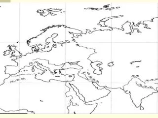
Physical Features September 5, 2012
Bay An area of the ocean that is partially enclosed by land; smaller than a gulf
Plateau A large area of raised, flat land
Archipelago A chain of islands.
Plain A large area of flat land.
Lake A large body of fresh water surrounded by land.
Volcano An opening in the Earth’s crust from which lava, ashes and gasses erupt.
River A large natural stream of fresh water that flows into a lake or an ocean.
Mountain A high, steep piece of land that rises sharply above the surrounding area.
Mountain Range A series of connecting mountains.
Gulf A large area of water ocean partially surrounded by land; larger than a bay.
Island An area of land completely surrounded by water.
Isthmus A narrow piece of land joining two larger bodies of land.
Ocean Any one of the four largest connecting bodies of salt water on the Earth’s surface.
Peninsula A piece of land mostly surrounded by water and attached to a larger area of land.
Strait A narrow body of water connecting two larger bodies of water.
Tributary A stream or river that flows into a larger stream or river.
Sea A body of water that is usually part of an ocean, and is partially or wholly enclosed by land.
Valley Land that lies between mountains or hills.
SALT - DOG • S • A • L • T • D • O • G
SCALE • Scale tells us distance on a map.
AUTHOR • Author tells us who made the map • (Cartographer)
LEGEND • Legend tells us what symbols mean on a map • (Key)
TITLE • Tells us WHAT the map is about
DATE • Date tells us when the map was made
ORIENTATION • Shows us what direction North is.
GRID • Shows us where things are located • Latitude and longitude make a grid