Download
1 / 44
450 likes | 579 Vues
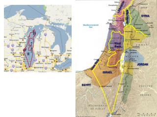
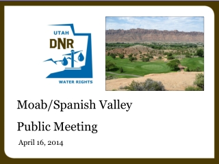
Moab/Spanish Valley Public Meeting April 16, 2014. Current Water Rights Policy Moab/Spanish Valley Public Meeting April 16, 2014. Moab/Spanish Valley Drainage. Mill Creek Confluence with Colorado 4952 feet Mount Tukuhnikivatz 12482 feet

E N D
Moab/Spanish Valley Public Meeting April 16, 2014
Current Water Rights Policy Moab/Spanish Valley Public Meeting April 16, 2014
Moab/Spanish Valley Drainage • Mill Creek Confluence with Colorado4952 feet • Mount Tukuhnikivatz12482 feet • LasalMtn precipitation gage (9850 ft)35.9 inches/year • Moab precipitation9.02 inches
Policy Page • Moab City • Mill Creek Upper Drainage
Moab/Spanish Valley Watershed Warner Lake Kens Lake Mill Creek Pack Creek Powerhouse Dam San Juan CountyGrand County
Moab/Spanish Valley Surface Water • New appropriations evaluated on own merits • Permanent change applications evaluated on own merits • May require installation of meters • May be regulated by River Commissioner Ground Water • Open to new appropriations • 1 Home, 1 acre irrigation, 10 head livestock
Mill Creek Drainage Surface and Ground Water • Closed to new appropriations • Must file permanent change on a first class • May require installation of meters • May be regulated by River Commissioner
Moab City Limits East of Main Street • No Appropriation for Homes • 0.25 acre irrigation • 10 head of livestock West of Main Street • No Appropriation for Homes • 1.0 acre irrigation • 10 head of livestock
Groundwater Management Plans Moab/Spanish Valley Public Meeting April 16, 2014
GroundwaterManagement Plans • Clarifying legislation enacted in 2006 • Established Section 73-5-15 of Utah Code • Tool to help the State Engineer distribute groundwater
Section 73-5-15 • (2) • (a) The state engineer may regulate groundwater withdrawals within a specific groundwater basin by adopting a groundwater management plan in accordance with this section for any groundwater basin or aquifer or combination of hydrologically connected groundwater basins or aquifers.
Section 73-5-15 • (2) • (b) The objectives of a groundwater management plan are to: • (i) limit groundwater withdrawals to safe yield; • (ii) protect physical integrity of the aquifer; and • (iii) protect water quality
Section 73-5-15 • (1) As used in this section: • (a) “Critical management area” means a groundwater basin in which the groundwater withdrawals consistently exceed the safe yield. • (b) “Safe yield” means the amount of groundwater that can be withdrawn from a groundwater basin over a period of time without exceeding the long-term recharge of the basin or unreasonably affecting the basin’s physical and chemical integrity.
Section 73-5-15 • (3) • (a) In developing a groundwater management plan, the state engineer may consider: • (i) the hydrology of the groundwater basin; • (ii) the physical characteristics of the groundwater basin; • (iii) the relationship between surface water and groundwater, including whether the groundwater should be managed in conjunction with hydrologically connected surface waters;
Section 73-5-15 • (3) • (a) In developing a groundwater management plan, the state engineer may consider: • (iv) the conjunctive management of water rights to facilitate and coordinate the lease, purchase, or voluntary use of water rights subject to the groundwater management plan; • (v) the geographic spacing and location of groundwater withdrawals; • (vi) water quality;
Section 73-5-15 • (3) • (a) In developing a groundwater management plan, the state engineer may consider: • (vii) local well interference; and • (viii) other relevant factors
Section 73-5-15 • (3) • (b) The state engineer shall base the provisions of a groundwater management plan on the principles of prior appropriation
Section 73-5-15 • (3) • (c) • (i) The state engineer shall use the best available scientific method to determine safe yield. • (ii) As hydrologic conditions change or additional information becomes available, safe yield determinations made by the state engineer may be revised...
Section 73-5-15 • (4) • (a) • (i) Except as provided in Subsection (4)(b), the withdrawal of water from a groundwater basin shall be limited to safe yield. • (ii) Before limiting the withdrawals in a groundwater basin to safe yield, the state engineer shall: • (A) determine the groundwater basin’s safe yield; and • (B) adopt a groundwater management plan for the groundwater basin.
Section 73-5-15 • Other Provisions • Process for public notice and involvement • Effective date of the plan • Notice of the final plan • Filing an appeal • Amending a plan • Existing plans are recognized
Recently Implemented Plans • Since enactment of 73-5-15, two groundwater management plans have been implemented • Beryl-Enterprise (2012) • Critical Management Area • Cedar Valley and Northern Utah Valley (2014) • Not a Critical Management Area • Plan set safe yield and policies to prevent exceeding safe yield
Safe Yield • Recharge is a starting point • May be less than recharge to protect physical integrity of the aquifer and water quality • Recharge is verified from a water budget • Inflows (recharge) = Outflows (discharge) + Change in storage
Water Budget • Recharge • Precipitation • Infiltration of runoff • Return flow from irrigation or other water uses • Discharge • Evapotranspiration • Well diversions • Discharge to springs and rivers • Change in Storage • Change in groundwater levels
Moab/Spanish Valley • Past studies • C.T. Sumsion, USGS, 1971 • Phil Gardner, University of Utah, 2004 • Mike Lowe, Janae Wallace, Stefan M. Kirby, and Charles E. Bishop, UGS, 2007 • Several other reports
Moab/Spanish Valley • Change in storage • Groundwater levels appear to be generally stable (little change in storage) • Recharge = Discharge
Moab/Spanish Valley • Recharge • Difficult to estimate • Many unknown components • Recharge boundaries • Precipitation infiltration rate and contribution of surrounding sandstone • Ken’s Lake seepage • Past reports use discharge to estimate recharge rather than estimating them independently and verifying
Moab/Spanish Valley • Discharge • Not directly measurable • Recharge/discharge a small fraction of Colorado River flow • Good estimates of: • Evapotranspiration (Irrigation and Wetlands) • Municipal well diversions • Differing estimates of: • Spring discharge • Discharge to Colorado River
Moab/Spanish Valley • Discharge to Colorado River • Sumsion 1971 – 8,000 AF • Estimated recharge as 14,000 AF • Gardner 2004 – 100 to 1,500 AF • No recharge estimate • More information is needed to determine safe yield
Moab/Spanish Valley • Water quality Modified Figure 4, Fall 2006 Assessment of Matheson Wetlands Hydrogeology and Ground Water Chemistry, Moab UMTRA Project, DOE, 2007 Part of Plate 3, UGS Special Study 120
Moab/Spanish Valley • Depletion amounts for perfected and approved groundwater rights • Irrigation ≈ 6,000 AF/yr • Municipal ≈ 13,000 AF/yr • Other Uses ≈ 2,500 AF/yr • Total ≈ 21,500 AF/yr • Current depletion ≈ 25%
Summary • Groundwater withdrawals currently do not appear to exceed safe yield • Potential groundwater withdrawals based on approved and perfected water rights may exceed safe yield • A groundwater management plan will help ensure that groundwater withdrawals do not exceed safe yield • Additional hydrologic information is needed prior to developing and implementing a groundwater management plan
Next Steps Moab/Spanish Valley Public Meeting April 16, 2014
Next Steps: • Development of a Technical Work Group • Collection of Additional Hydrologic Data • Collection of Additional Water Quality Data • Review and Analysis of Data • Recommendations to State Engineer
Technical Work Group: • Suggested Involvement from: • Division of Water Rights / Water Quality • Grand / San Juan Counties • Moab City • Grand Water & Sewer Service Agency • San Juan Spanish Valley Special Service District • State Institutional Trust Lands Administration • Forest Service / BLM • Moab Area Watershed Partnership • NGO’s / Private Well Owners
Technical Work Group: • Purpose: • Provide Scope of Work for Research Studies • Assist in Funding for Research Studies • Receive Regular Updates from Research Studies • Review and Provide Analysis of Completed Studies • Provide Recommendations to State Engineer
Collection of Additional Data: • Hydrology • Surface / Underground • Recharge, Discharge, Safe Yield • Physical Characteristics of Basin Aquifers • Alluvial, Bedrock, Faults, Divides • Water Quality • Water Rights Inventory / Current Water Use
Proposed USGS Study • Objectives • Refine estimates of selected groundwater recharge and discharge budget components • Improve conceptual understanding of the aquifer system and hydraulic connection between aquifers Figure 1, USGS Study Proposal
Collection of Additional Data: • Proposed U.S. Geological Survey Study (2015-2017) • Develop New Estimate of Groundwater Recharge • Estimation of Spring Discharge • Stream Seepage Studies • Estimation of Well Withdrawals • Estimation of Evapotranspiration • Estimation of Discharge to Colorado River • Definition of Groundwater Divides • Groundwater Chemistry and Dating
Final Steps: • Review and Analysis of Data • Recommendations to State Engineer • Economic Impacts • Individual Water Users • Local Community • Timing of Implementation
Possible Outcomes: • Stay with Current Open but Limited Appropriation Policy • Place More Restrictions on Appropriation Policy • Close the Valley to New Appropriations / Limit Change Applications to within the Valley
Thank You… Any Questions? • Address for written comments Utah Division of Water Rights Marc Stilson, Regional Engineer 319 North Carbonville Road P.O. Box 718 Price, UT 84501