Download
1 / 53
540 likes | 755 Vues
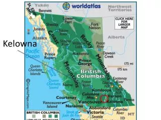
GIS BASED SEISMIC DAMAGE ESTIMATION FOR THE CITY OF KELOWNA. Md . Nurul Alam Graduate Student Supervisors: Dr. Solomon Tesfamariam and Dr. M. Shahria Alam. 6.4 Magnitude Quake Shakes Southwest B.C. Friday, September 09, 2011 at 12:41:34 PM ( Source : USGS).

E N D
GIS BASED SEISMIC DAMAGE ESTIMATION FOR THE CITY OF KELOWNA Md. Nurul Alam Graduate Student Supervisors: Dr. Solomon Tesfamariam and Dr. M. ShahriaAlam
6.4 Magnitude Quake Shakes Southwest B.C. Friday, September 09, 2011 at 12:41:34 PM ( Source : USGS)
USGS PAGER - Prompt Assessment of Global Earthquakes for Response Report Green Alert
Outline • Background • Methodology • Outcome • Conclusion & Future Directions
Effects of Earthquake in Haiti, January 2010
Effects of Earthquake in Chile, February 2010
“Know Risk, No Risk” International Strategy for Disaster Reduction
Objective • Development of a GIS-based Seismic Damage Assessment Tool with the help of RADIUS • Implement a Case Study for the City of Kelowna
RADIUS Risk Assessment Tools for Diagnosis of Urban Areas against Seismic Disasters
Proposed GIS based RADIUS Method Query GIS Modeling for Input Approved Data Collection Data Inventory Quality Inspection Engineering Analysis with RADIUS Generation of Seismic Damage Maps in GIS Not Approved
Scenario Earthquake Selection Seismic Hazard Seismic Damage Estimation Soil Classification Data Inventory and Vulnerability GIS Platform Simplified RADIUS Methodology ( After Nippon Koi and Oyo 2001)
What is GIS? Geographic Information System
GIS Implementation Process Sources Analog2Digital Layering Output & Analysis Design & Linking
Scenario Earthquake Selection Seismic Hazard Seismic Damage Estimation Soil Classification Data Inventory and Vulnerability
Selection of Probable Seismic Event • Scenario 1: Mw = 6.5 underneath the City • Scenario 2: Mw = 7.3 in Cascadia Subduction Zone
Scenario Earthquake Selection Seismic Hazard Seismic Damage Estimation Soil Classification Data Inventory and Vulnerability Simplified RADIUS Methodology
Surface Ground Amplification for Different Soil/Rock types in RADIUS (After Nippon Koi and Oyo 2001)
Scenario Earthquake Selection Seismic Hazard Seismic Damage Estimation Soil Classification Data Inventory and Vulnerability
Data Sources • Secondary Data • City of Kelowna • Statistics Canada • USGS • Agriculture Canada • UBC Vancouver • Primary Data • Survey through Google maps
Study Area with 4km × 4km grids Basic Input for RADIUS
Scenario Earthquake Selection Seismic Hazard Seismic Damage Estimation Soil Classification Data Inventory and Vulnerability Simplified RADIUS Methodology
Mean damage factors (MDF) for major classes of buildings in Kelowna (After Onur et al. 2005)
Casualty Coefficient After UNISDR 1999
Scenario 1 : Mw = 6.5 underneath the City Distribution of Casualties ( Casualty Count :161) Distribution of Damaged Buildings (Count : 2374) Distribution of MMI
Scenario 2 : Mw =7.3 in Cascadia Subduction Zone Distribution of Building Damage Distribution of Injuries Distribution of MMI
Acknowledgement • NSERC • City of Kelowna • Professor Dwayne Tannant, UBC O • Mr. Norm Williams, Interior Testing Services Ltd. • Agriculture Canada • Statistics Canada
Acknowledgement • Mr. Mo Bayat, Director, Development Services Department, The City of Kelowna • Mr. John Vos,General Manager, Community Services Division, The City of Kelowna • Mr. Darren Genge , GIS Technician , Policy & Planning, The City of Kelowna • Mr. TaherAhmed, RBO, The City of Kelowna
Selected Risky Areas A8, C2, C3, C8, D6, D7 and E7
Goal & Main Tasks of the project… Overall Goal: • To develop a comprehensive multi-hazard risk reduction “Contingency Planning” strategy that is linked to an easy implementation framework Main Tasks: • Task I: Determine status of existing contingency plans • Task II: Turn existing contingency plans into scenario-based contingency plans (using geo-hazard vulnerability map)
Contingency Planning Framework Establish the Context in Relation to Potential Hazards Vulnerability Assessment & Loss Estimation • Scenario Development • (Scenario will be developed using RADIUS tool) • Low Risk • Moderate Risk • High Risk Develop Template for Contingency Plans to Address Needs and Suite Risk Scenarios Plan Development at City Level
Review Mandates for Various Levels & Sectors Extended Roles and Responsibilities of agencies Compare with existing and Gap analysis Training & Capacity Building Urban planning solutions Pre-positioning of facilities Contingency Planning Framework Establish the Context in Relation to Potential Hazards Vulnerability Assessment & Loss Estimation Scenario Development • Low Risk, Moderate Risk, High Risk Develop Template for Contingency Plans to Address Needs and Suite Risk Scenarios Plan Development at Various Levels Perform Review & Revision After Major Events or as needed
W h o , W h a t , W h e r e • Coordination and Support • Services • Disaster Management • Education • Food Security • Health / Health and Nutrition • Infrastructure • Livelihood Economic recovery • Protection • Shelter • Water Hygiene and Sanitation • Psycho social • Early Recovery