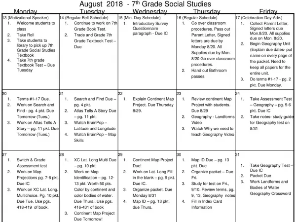
Download
1 / 45
450 likes | 1.36k Vues
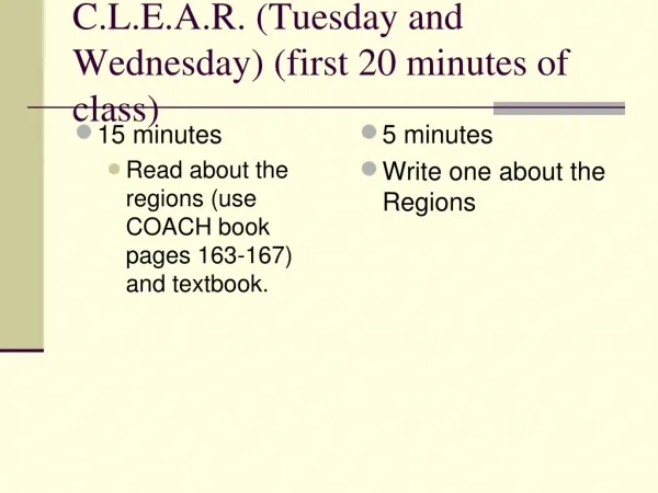
C.L.E.A.R. (Tuesday and Wednesday) (first 20 minutes of class). 15 minutes Read about the regions (use COACH book pages 163-167) and textbook. 5 minutes Write one about the Regions. Warm Up Preparation. Cornell note style: Draw line in middle of paper: Question on the left

E N D
C.L.E.A.R. (Tuesday and Wednesday) (first 20 minutes of class) • 15 minutes • Read about the regions (use COACH book pages 163-167) and textbook. • 5 minutes • Write one about the Regions
Warm Up Preparation • Cornell note style: • Draw line in middle of paper: • Question on the left • Answer on the right • What region is the state of Georgia located in within the United States?
Unit 1 Geography Georgia Performance Standard (GPS) SS8G1: The student will describe Georgia with regard to physical features and location.
SS8G1 a. Locate Georgia in relation to region, nation, continent, and hemispheres. • What is Geography? • Geography – the science of studying the earth.
SS8G1 a. Locate Georgia in relation to region, nation, continent, and hemispheres. • Latitude – parallel lines that run east and west, but measure north and south locations on the earth’s surface. • *Draw circle with a line in the middle from side to side
SS8G1 a. Locate Georgia in relation to region, nation, continent, and hemispheres. • Longitude – meridian lines that run north and south, but measure east and west locations on the earth’s surface. • *Draw circle with a line in the middle from top to bottom
SS8G1 a. Locate Georgia in relation to region, nation, continent, and hemispheres. • The Equator and Prime Meridian divide the earth into hemispheres. • Hemispheres – two halves of a sphere.
SS8G1 a. Locate Georgia in relation to region, nation, continent, and hemispheres.
SS8G1 a. Locate Georgia in relation to region, nation, continent, and hemispheres.
SS8G1 a. Locate Georgia in relation to region, nation, continent, and hemispheres. • Quick Geography Review/Quiz • 1. How many continents are on the earth’s surface? • 2. What continent is the state of Georgia located in? • 3. What nation is Georgia apart of? • 4. What are the major lines of latitude and longitude and what do they do? • 5. How many hemispheres are there? • 6. What hemisphere is the state of Georgia located in? (2 answers)
SS8G1 a. Locate Georgia in relation to region, nation, continent, and hemispheres.
SS8G1 a. Locate Georgia in relation to region, nation, continent, and hemispheres. • What region is the state of Georgia located in within the United States?
SS8G1 b. Describe the five geographic regions of Georgia, include the Blue Ridge Mountains, Ridge and Valley, Appalachian Plateau, Piedmont, and Coastal Plain.
SS8G1 b. Describe the five geographic regions of Georgia, include the Blue Ridge Mountains, Ridge and Valley, Appalachian Plateau, Piedmont, and Coastal Plain. • What is a region? • A region is the basic unit of study in geography.
Georgia’s 5 physiographic regions: • 1) The Appalachian Plateau • 2) The Ridge & Valley Region • 3) The Blue Ridge Region • 4) The Piedmont Plateau • 5) The Coastal Plain
SS8G1 b. Describe the five geographic regions of Georgia, include the Blue Ridge Mountains, Ridge and Valley, Appalachian Plateau, Piedmont, and Coastal Plain. • Appalachian Plateau: • Smallest of the regions • It is a maze of limestone caves, deep canyons, and interesting rock formations • Far northwestern corner of the state
SS8G1 b. Describe the five geographic regions of Georgia, include the Blue Ridge Mountains, Ridge and Valley, Appalachian Plateau, Piedmont, and Coastal Plain. • Ridge and Valley: • Has low open valleys and narrow ridges that run parallel to the valleys. • Forests & pastures dominate the region, but there are flat and fertile farmlands.
SS8G1 b. Describe the five geographic regions of Georgia, include the Blue Ridge Mountains, Ridge and Valley, Appalachian Plateau, Piedmont, and Coastal Plain. • Blue Ridge Region: • Known for its rugged beauty • Located in northeastern GA • The highest and largest group of mountains in Georgia is in this region
SS8G1 b. Describe the five geographic regions of Georgia, include the Blue Ridge Mountains, Ridge and Valley, Appalachian Plateau, Piedmont, and Coastal Plain. • Blue Ridge (cont.): • Brasstown Bald, the highest peak in the state, is located in this region. (Almost 5000 ft. high)
SS8G1 b. Describe the five geographic regions of Georgia, include the Blue Ridge Mountains, Ridge and Valley, Appalachian Plateau, Piedmont, and Coastal Plain. • Piedmont: • Begins in the mountain foothills of GA and goes to the central part of the state • This granite-based landform makes up about 1/3 of the state’s land area. • About ½ of the state’s population lives in the Piedmont region
Think Pair Share: • What Region is Conyers, GA located in?
SS8G1 b. Describe the five geographic regions of Georgia, include the Blue Ridge Mountains, Ridge and Valley, Appalachian Plateau, Piedmont, and Coastal Plain. • The Coastal Plain: • Largest region, occupies three-fifths of the state • It is the major agricultural region of the state, with soil that varies from limestone to clay. • The Coastal Plain region is separated from the Piedmont Plateau by a natural boundary known as the Fall Line.
Mini Activity • Draw an outline of Georgia and Identify the following areas. This will remain in your notebook: • 1) The Appalachian Plateau • 2) The Ridge & Valley Region • 3) The Blue Ridge Region • 4) The Piedmont Plateau • 5) The Coastal Plain • Use textbook page 157 in Coach book to assist • (5 minutes) • (3 Minutes) • Check the papers of 3 other people (any 3)
Lesson part 2: c. Locate and evaluate the importance of key physical features on the development of Georgia; include the Fall Line, Okefenokee Swamp, Appalachian Mountains, Chattahoochee and Savannah Rivers, and barrier islands.
c. Locate and evaluate the importance of key physical features on the development of Georgia; include the Fall Line, Okefenokee Swamp, Appalachian Mountains, Chattahoochee and Savannah Rivers, and barrier islands. • The Fall Line • Separates the Piedmont and Coastal plain • a boundary about 20 miles wide that runs across Georgia. • Called Fall Line due to its many water falls. • Major Cities along Fall Line: • 1. Augusta • 2. Macon • 3. Columbus • 4. Milledgeville
c. Locate and evaluate the importance of key physical features on the development of Georgia; include the Fall Line, Okefenokee Swamp, Appalachian Mountains, Chattahoochee and Savannah Rivers, and barrier islands. • Okefenokee Swamp • Located in the southeast corner of Georgia • It is the largest swamp in North America. (Almost covers 700 miles) • Home to more than 400 species of animals. • Became the Okefenokee National Wildlife Refuge in 1937
c. Locate and evaluate the importance of key physical features on the development of Georgia; include the Fall Line, Okefenokee Swamp, Appalachian Mountains, Chattahoochee and Savannah Rivers, and barrier islands. • Appalachian Mountains • Southernmost part of the Appalachian Mountains are the Blue Ridge Mountains. • GA’s highest and wettest areas(over 80 inches of annual rainfall)
Appalachian Mountains (cont.) • The crest (top) of the mountains form the Continental Divide. • Divides the direction in which rivers drain • West flowing rivers empty into the Gulf of Mexico • East flowing rivers empty into the Atlantic Ocean
c. Locate and evaluate the importance of key physical features on the development of Georgia; include the Fall Line, Okefenokee Swamp, Appalachian Mountains, Chattahoochee and Savannah Rivers, and barrier islands. • Chattahoochee River • Begins in the Blue Ridge Mountains • Flows southwest towards Alabama and into the Gulf of Mexico • Important for Georgians for: • 1. Drinking Water • 2. hydroelectric power • 3. recreation
c. Locate and evaluate the importance of key physical features on the development of Georgia; include the Fall Line, Okefenokee Swamp, Appalachian Mountains, Chattahoochee and Savannah Rivers, and barrier islands. • Savannah River • Natural boundary between Georgia and South Carolina • Flows southeast into the Atlantic Ocean • Important for Georgians for: • 1. Drinking Water • 2. hydroelectric power • 3. recreation
c. Locate and evaluate the importance of key physical features on the development of Georgia; include the Fall Line, Okefenokee Swamp, Appalachian Mountains, Chattahoochee and Savannah Rivers, and barrier islands. • Barrier Islands • Barrier islands are found along nearly the entire eastern seaboard of United States. • They protect the mainland from storms. • Important for tourism, fishing, and paper production
Activity part 2 • Locate and label the following places: • (5 minutes) • (3 Minutes) • Check the paper of 3 other people. • Fall Line • Okefenokee Swamp • Appalachian Mountains • Chattahoochee and Savannah Rivers • barrier islands
d. Evaluate the impact of climate on Georgia’s development. • Weather – The day to day change of the earth’s atmosphere in regard to temperature, moisture, wind velocity and pressure. • Climate – the average of weather patterns measured over a long period of time.
Closing Questions (At the end of the notes) Choose 2 out of the 5 to write and answer. Please ensure that you have a complete sentence. For example: (if you answer #1: Georgia is in the_________________
Georgia’s Climate • Georgia's climate varies from the mountainsto the Coastal Plain beaches. • Temperate and influenced by Georgia's proximity (distance) to the Atlantic Ocean and the Gulf of Mexico • In winter there are blasts of cold Arctic air coming southward from Canada.
1. Georgia’s climate can be described as mild, temperate, or humid subtropical. • 2. Winters in Georgia are cool while summers are warm to hot. • 3. Both the Piedmont and Coastal Plain regions have longer and hotter summers because of their location near/in between the warm waters of the Gulf of Mexico and the Atlantic Ocean.
DLIQ • Do • Learn • Interesting • Questions
C.L.E.A.R. • Read you in Coach book about the physical features (162-167) • 15 minutes • 5 minutes • Write one paragraph about the physical features
Thursday/Friday • Activity Part 1: • A: Create a Georgia Regions Flip book: • List the 5 regions and the following: • -4 characteristics unique to that region • -physical features in that area • -Climate of that region • -Location of that region • Use page 164-167
Ticket Out of the Door • Name and describe the 5 regions of Georgia.
DLIQ • Do • Learn • Interesting • Question
Thursday/Friday Part 2 • In your small groups, create a large map of Georgia that identifies the following areas: Color the following regions: • Blue Ridge (Blue) • Piedmont (Red); • Fall Line (black); • Coastal Plain (yellow); • Appalachian Plateau (gray); • Ridge and Valley (green); Locate and identify on your map the following areas: • Okefenokee Swamp, • Appalachian Mountains, • Chattahoochee Rivers • Savannah Rivers • barrier islands.
DLIQ • Do • Learn • Interesting • Question