Download

1 / 7
70 likes | 200 Vues
Why Mapping the Public Service is Important: European and Irish Initiatives. Greg Mc Dermott Property Registration Authority 4 th Oct 2011. Reality . There are lots of spatial databases within the Public Sector OSi, PRA, Dept of Agriculture, DECLG, Bord Na Mona, Coillte, etc……

E N D
Why Mapping the Public Service is Important: European and Irish Initiatives Greg Mc Dermott Property Registration Authority 4th Oct 2011
Reality • There are lots of spatial databases within the Public Sector • OSi, PRA, Dept of Agriculture, DECLG, Bord Na Mona, Coillte, etc…… • No required uniformity – based on individual needs • Duplication of data • Unconnected services (Not joined-up thinking) • Lost potential
Common Thread • Everything you need to know about has a location element • Service request • Service delivery • Crime incident • Educational requirements • Etc……..
Why the need ? • Increased recognition of the value of Geographic Information Systems in Government • Increased use of geographic based business analysis tools • Need to Reduce costs • Many related datasets are unconnected and duplicated across Public Sector • Need to increase effectiveness/improved delivery of public services • Need for evidence based and focused policy making • Best value for money investment • Horizontal view rather than vertical view of Public Sector • Need for compliance (INSPIRE, ISDI) • Increasing need for spatially referenced reporting • Health, education, employment etc. • Anonymised • Patterns and Trends
Current Position • No Government strategy in relation to Geographic/Spatial information • Decisions made on local/individual needs • Internationally the need for a strategy is well recognised • Common Reference Data through INSPIRE Compliance • Standard Data Specifications • Discovery, View and Download Services
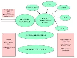
INSPIRE/ISDI • INSPIRE (Infrastructure for Spatial Information in Europe) • INSPIRE Compliance Group • Reference Framework • 3 Annexes • Irish INSPIRE Portal (ISDE) • Visibility and Accessibility • ISDI (Irish Spatial Data Infrastructure) • Can Use and Build on INSPIRE Framework • Collaborative activities • Shared Services • Demands compliance
What needs to be done • Adopt INSPIRE Data Standards/Specifications and Principles as a basis for ISDI • Re-emphasise and drive the development of a Public Sector Wide GI/Spatial data strategy for Ireland which goes beyond INSPIRE Compliance • Ensure that all spatial datasets are identified and available at appropriate levels for use to other Public Sector Bodies • Set about adding a spatial reference (geo-locator) to other non-spatial datasets • Ensure that all funding/sanctions for spatial systems developments adhere to the spatial strategy • Unlock and Exploit the value!!!