RNP
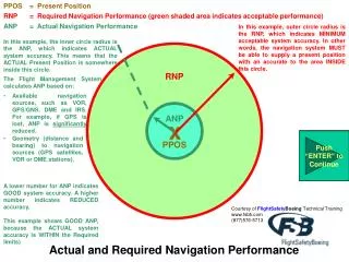
PPOS = Present Position. Courtesy of FlightSafety Boeing Technical Training www.fsbti.com (877)576-5713. Actual and Required Navigation Performance. RNP = Required Navigation Performance (green shaded area indicates acceptable performance) . ANP = Actual Navigation Performance.

RNP
E N D
Presentation Transcript
PPOS = Present Position Courtesy of FlightSafetyBoeing Technical Training www.fsbti.com (877)576-5713 Actual and Required Navigation Performance RNP = Required Navigation Performance (green shaded area indicates acceptable performance) ANP = Actual Navigation Performance In this example, outer circle radius is the RNP, which indicates MINIMUM acceptable system accuracy. In other words, the navigation system MUST be able to supply a present position with an accurate to the area INSIDE this circle. In this example, the inner circle radius is the ANP, which indicates ACTUAL system accuracy. This means that the ACTUAL Present Position is somewhere inside this circle. RNP The Flight Management System calculates ANP based on: • Available navigation sources, such as VOR, GPS/GNS, DME and IRS. For example, if GPS is lost, ANP is significantly reduced. ANP x Push “ENTER” to Continue Push “ENTER” to Continue Push “ENTER” to Continue Push “ENTER” to Continue Push “ENTER” to Continue • Geometry (distance and bearing) to navigation sources (GPS satellites, VOR or DME stations). PPOS A lower number for ANP indicates GOOD system accuracy. A higher number indicates REDUCED accuracy. This example shows GOOD ANP, because the ACTUAL system accuracy is WITHIN the Required limits)
PPOS = Present Position RNP = Required Navigation Performance (green shaded area indicates acceptable performance) ANP = Actual Navigation Performance Courtesy of FlightSafetyBoeing Technical Training www.fsbti.com (877)576-5713 Actual and Required Navigation Performance Provided courtesy of FlightSafetyBoeing CLICK HERE FOR MORE INFORMATION This example shows BAD ANP (OUTER circle), because ANP > RNP • ACTUAL system accuracy ANP NOT within Required limits Present Position is only accurate to the within the radius of the ANP. If ANP exceeds RNP a message of “UNABLE RNP” is usually displayed. This does not indicate that the position is incorrect. It merely indicates that FMS cannot guarantee accuracy of Present Position within Required limits. RNP x Push “ENTER” to Continue Push “ENTER” to Continue Push “ENTER” to Continue PPOS This is calculated based on quality and availability of data being used by FMS. Accuracy degradation can come from many factors (signal geometry, or failed systems, etc.)