Download
1 / 58
580 likes | 899 Vues
Map-Based Flood Hydrology and Hydraulics. David R. Maidment Jan 10, 1998. Map-Based Hydrology and Hydraulics. Connecting ArcView with HMS for the Austin Region Flood simulation using Nexrad data in Houston HMS-RAS for Waller Creek in Austin Creating flood plain maps in Waller Creek.

E N D
Map-Based Flood Hydrology and Hydraulics David R. Maidment Jan 10, 1998
Map-Based Hydrology and Hydraulics • Connecting ArcView with HMS for the Austin Region • Flood simulation using Nexrad data in Houston • HMS-RAS for Waller Creek in Austin • Creating flood plain maps in Waller Creek
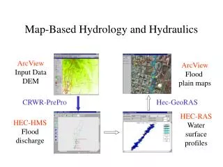
Map-Based Hydrology and Hydraulics ArcView Input Data DEM ArcView Flood plain maps CRWR-PrePro HEC-RAS Water surface profiles HEC-HMS Flood discharge
Austin Digital Elevation Model Waller Creek
CRWR-PrePro Digital Elevation Model Stream Map ArcView-based preprocessor for HEC-Hydrologic Modeling System (HEC-HMS) Control point locations HMS Basin File
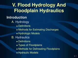
Presentation Outline • Using GIS to connect hydrology and meteorology • Representation of spatial objects in GIS • Terrain analysis using Digital Elevation Models • Geodesy and map projections
Study Region in West Austin Hog Pen Ck 4 km 4 km
Watershed Delineation by Hand Digitizing Watershed divide Outlet Drainage direction
DEM Elevations 720 720 Contours 740 720 700 680 740 720 700 680
DEM Elevations Contours 700 680
32 64 128 16 1 8 4 2 Eight Direction Pour Point Model
67 56 49 53 44 37 58 55 22 Direction of Steepest Descent 1 1 67 56 49 53 44 37 58 55 22 Slope:
2 2 4 4 8 1 2 4 8 4 128 1 2 4 8 2 1 4 4 4 1 1 1 2 16 Flow Direction Grid
Austin West 30 Meter DEMElevations in meters ftp://ftp.tnris.state.tx.us/tnris/demA.html
32 64 128 16 1 8 4 2 Flow Direction Grid
Flow Accumulation Grid 0 0 0 0 0 0 0 0 0 0 0 3 2 2 0 3 2 0 0 2 0 0 1 0 0 11 0 1 0 11 0 0 0 1 15 0 0 1 0 15 1 0 2 5 24 2 5 0 1 24 Link to Grid calculator
0 0 0 0 0 0 3 2 2 0 0 1 0 0 11 0 0 0 1 15 1 0 2 5 24 Flow Accumulation > 5 Cell Threshold
Stream Network for 5 cell Threshold Drainage Area 0 0 0 0 0 3 2 0 0 2 0 0 1 0 11 0 0 1 0 15 2 5 0 1 24
Streams with 200 cell Threshold(>18 hectares or 13.5 acres drainage area)
Watershed andDrainage PathsDelineated from 30m DEM Automated method is more consistent than hand delineation
DEM Data Sources for Texas • Digital terrain models with 2’ or 4’ contours built from aerial photogrammetry • 10m DE-DEMs, from 1:24,000 scale maps with drainage enforcement (experimental) • 30m DEMs from 1:24,000 scale maps • 1” seamless DEM of Texas (March, 1999) • 3" (100m) DEMs from 1:250,000 scale maps (current state-wide coverage)
Selected Watersheds and Streams Mansfield Dam Colorado River
HMS Schematic Prepared with CRWR-PrePro Mansfield Dam Colorado River
HMS Basin File Basin file is a text description of all hydrologic elements 155 33 87 Subbasin 39 Reach Junction
HMS Results Watershed 155 Junction 44
Map-Based Hydrology and Hydraulics • Connecting ArcView with HMS for the Austin Region • Flood simulation using Nexrad data in Houston • HMS-RAS for Waller Creek in Austin • Creating flood plain maps in Waller Creek
Regional flood analysis in Houston Study region
Study Region in West HoustonMaps Developed using CRWR-Prepro by Seth Ahrens
Map-Based Hydrology and Hydraulics • Connecting ArcView with HMS for the Austin Region • Flood simulation using Nexrad data in Houston • HMS-RAS for Waller Creek in Austin • Creating flood plain maps in Waller Creek
Map-Based Hydrology and Hydraulics • Connecting ArcView with HMS for the Austin Region • Flood simulation using Nexrad data in Houston • HMS-RAS for Waller Creek in Austin • Creating flood plain maps in Waller Creek