Download
1 / 1
10 likes | 106 Vues
Explore ABI proxy data set generation at CIMSS for GOES-R, including WRF model simulations and remapping techniques for simulating ABI data.

E N D
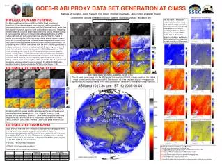
GOES-R ABI PROXY DATA SET GENERATION AT CIMSS P1.87 Mathew M. Gunshor, Justin Sieglaff, Erik Olson, Thomas Greenwald, Jason Otkin, and Allen Huang Cooperative Institute for Meteorological Satellite Studies (CIMSS) – Madison, WI INTRODUCTION AND PURPOSE ABI will have a mesoscale mode that allows it to focus on a specific target every 30 seconds, without interrupting other aspects of the ABI scanning schedule. These images are from the WRF-model 667-m Mesoscale domain simulation and depict the beginning of a convective system forming in Oklahoma. 88th AMS Annual Meeting 5th GOES User’s Conference – 23-24 January, 2008 – New Orleans, LA The Advanced Baseline Imager (ABI) on GOES-R will represent a technological leap in weather and environmental satellite capabilities. Improvements over the current imager include 16 spectral bands, faster data rates, spatial resolution, signal to noise and calibration accuracy. Preparing users for what lies ahead is a task being tackled by various research groups. At the Cooperative Institute for Meteorological Satellite Studies (CIMSS) multiple data sets are being generated in an effort to meet the needs of various GOES-R Algorithm Working Group (AWG) science teams. Parallel efforts are underway to provide simulated Advanced Baseline Imager (ABI) data from both existing satellite assets and from the Weather Research and Forecasting (WRF) model. Simulations from the WRF are being produced at multiple resolutions / time intervals to simulate ABI scanning scenarios: 15 minute full disk and 5 minute Continental US (CONUS) capabilities. WRF model simulations are turned into ABI imagery using a forward radiative transfer model (Poster P1.68) that incorporates both clear and cloudy-sky properties and a reflected component for the shortwave and visible bands. Some simulated datasets contain simulated instrument effects such as striping, random noise, and navigation shifts (Poster P1.47). A sophisticated remapping technique is being used to simulate the ABI from MODerate-resolution Imaging Spectroradiometer (MODIS) data (Poster 1.35). ABI SIMULATED FROM SATELLITE The 16 panel image comes from the WRF-model 2km resolution CONUS domain simulation, the full disk image comes from the 6-km resolution Full Disk domain. All of the simulated data are remapped to an approximate ABI projection based on the ideal Geostationary view from 75 West at ABI spatial resolution. Simulating ABI from current satellite data requires the use of three current instruments to simulate every band. This 16-panel, showing France, required MODIS, Meteosat, and AIRS. Other simulations have been done using just MODIS and include a Fire and Smoke Case, Mountain Wave Case, Convective Cloud Case, Daytime Cloud Case, and a Mexican Dust Case. ABI SIMULATED FROM MODEL • Large, memory-intensive WRF model simulations were recently performed on a high-performance supercomputer at the National Center for Supercomputing Applications (NCSA) at the University of Illinois in Urbana-Champaign (See Poster P1.20). ABI data were simulated from 3 nested domains configured to represent the anticipated GOES-R scanning regions (i.e. full disk, CONUS, and mesoscale). • Full Disk: 6-km horizontal resolution • CONUS: 2-km horizontal resolution • Mesoscale: 667-m horizontal resolution Related oral presentations and Posters: 2.2 The ABI (Advanced Baseline Imager) on the GOES-R Series P1.3 Candidate approaches for the real-time generation of cloud properties from GOES-R ABI P1.11 GOES-R wind retrieval algorithm development P1.20 Large-scale WRF model simulations used for GOES-R research activities P1.35 Proxy ABI datasets relevant for fire detection that are derived from MODIS data P1.40 Trade-off studies on future GOES hyperspectral infrared sounding instrument P1.68 Verifying large-scale, high-resolution simulations of clouds for GOES-R activities P1.86 Current GOES Sounder applications and future needs P1.89 GOES-R/ABI legacy profile algorithm evaluation with MSG/SEVIRI 5.4 NOAA/NESDIS GOES-R AWG and its Role in the Development and Readiness of GOES-R Product Algorithms