Download
1 / 15
150 likes | 261 Vues
Updates to the nesdis tropical cyclone formation probability product. Andrea Schumacher 1 , Mark DeMaria 2 , John Knaff 3 , Liqun Ma 4 and Hazari Syed 5 1 CIRA, Colorado State University, Fort Collins, Colorado 2 NOAA/NWS/NHC, Miami, FL 3 NOAA/NESDIS/STAR, Fort Collins, Colorado

E N D
Updates to the nesdis tropical cyclone formation probability product Andrea Schumacher1, Mark DeMaria2, John Knaff3, Liqun Ma4and HazariSyed5 1 CIRA, Colorado State University, Fort Collins, Colorado 2NOAA/NWS/NHC, Miami, FL 3 NOAA/NESDIS/STAR, Fort Collins, Colorado 4NOAA/NESDIS/OSPO, College Park, Maryland 5NOAA/NESDIS/OSPO, SSAI, College Park, Maryland AMS 31st Conference on Hurricanes and Tropical Meteorology, San Diego, CA, 31 Mar 2014
Outline • Motivation & Past Work (24-hr TCFP) • Extending to 48 hrs • Algorithm Overview • Examples from 2013 • 2013 Verification • Future Work AMS 31st Conference on Hurricanes and Tropical Meteorology
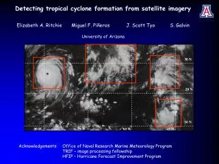
Motivation & past work • Need for objective, real-time TC formation guidance • Development of NESDIS TC Formation Probability (TCFP) product • Estimates probability of TC formation in next 24 hrs • 5 x 5 degree latitude/longitude grid boxes • Originally just in Atlantic and E. Pacific (2006), extended to N. W. Pacific (2009), then made global (2013) • Uses synoptic (GFS), convective (geostationary water vapor), and ocean (Reynold’s SST) predictors AMS 31st Conference on Hurricanes and Tropical Meteorology
Extending TCFP to 48 hours • Official forecast agencies provide 48-hr TC formation products • NHC Tropical Weather Outlook • JTWC TC Formation Alerts • Mismatch between TCFP guidance and user needs • Basic idea • Use GFS forecast fields • Satellite predictors most important at early times • Challenges • Pre-TC disturbances can move far in 48 hours • Fixed-domain scheme can’t account for motion • Disturbance-following schemes have advantage • Balancing increase in size spatial averaging vs. loss of signal AMS 31st Conference on Hurricanes and Tropical Meteorology
Spatial averaging • Discrete 5 x 5 degree grid boxes • Some predictors would be divided between 2 grid boxes when disturbance at the edge of a grid box • E.g., PCCD (% cold cloud coverage) • Would lead to “probability pulsing” • Introduced new spatial averaging • 1-degree resolution domain • 0-360E, 45S to 45N • Value at each point is average over r = 500km (larger than 5 x 5 degree boxes) • Still some “probability pulsing” most likely due to diurnal variations in convection R = 500 km • New product estimates the probability of TC formation within 500 km in the next 48 hours AMS 31st Conference on Hurricanes and Tropical Meteorology
data • Development data • ATL: 1995-2012 • NEPA: 1998-2012 • NWPA: 2000-2012 • NIO: 2005-2012 • SIO: 2005-2012 • SHM: 2005-2012 • Limiting dataset = water vapor imagery • Development done by basin AMS 31st Conference on Hurricanes and Tropical Meteorology
screening • # non-genesis cases >> # genesis cases • Screened out cases where one or more predictors were very hostile to genesis • Screened out cases within 300 km of existing TC, over land • For each predictor, found threshold for which less than 1% of formation cases occurred • Examples for VSHD, RVOR, and MLRH: AMS 31st Conference on Hurricanes and Tropical Meteorology
Linear discriminant analysis • Linear discriminant analysis (LDA) is a method used to find a linear combination of predictors that separates two or more classes of events • Here, classes are “genesis” and “non-genesis” • LDA finds coefficients provide max separation in standard deviation space • Top 4 contributing predictors by basin: AMS 31st Conference on Hurricanes and Tropical Meteorology
Estimating 48-hr probability • LDA yields a linear function (F) that provides binary classification • Genesis or No Genesis • However, F itself is not binary • Separated genesis cases into 10 equal bins by F and computed genesis frequency P(24h U 48h) = P(24h) + P(48h) + P(24h ∩ 48h) AMS 31st Conference on Hurricanes and Tropical Meteorology
product Examples 36 hours prior to 2 genesis events: Manuel (E Pac) Man-Yi (NW Pac) AMS 31st Conference on Hurricanes and Tropical Meteorology
2013 verification AMS 31st Conference on Hurricanes and Tropical Meteorology
2013 verification - Reliability • EXCEL HAS FAILED ME THIS MORNING!!!! • Basic takeaway from plots Under-prediction in all basins AMS 31st Conference on Hurricanes and Tropical Meteorology
Future work • Tropical Weather Outlook includes 120-hr formation probability • New in 2013 • From a practical standpoint, extending TCFP to 120 hours is straightforward • Challenge: Disturbance motion may be even bigger problem • Increase size of spatial averages? • Preliminary work underway • Hybrid TCFP / disturbance-following genesis model • E.g., TCGI, regional dynamical model • TCFP can identify regions of highest formation likelihood • Trigger disturbance-centric model AMS 31st Conference on Hurricanes and Tropical Meteorology
Summary • TCFP extended to 48 hours • http://www.ssd.noaa.gov/PS/TROP/TCFP/index.html • New spatial averaging scheme works well • Increased overall probabilities • 24hr product: 10-20% • 48hr product: 20-50% • Still systematically underpredicting, especially at higher probabilities • Brier skill scores suggest higher skill than climatology AMS 31st Conference on Hurricanes and Tropical Meteorology
Questions? • References AMS 31st Conference on Hurricanes and Tropical Meteorology