Chapter 10 Streams and Floods
720 likes | 1.66k Vues
GEOL 101 Introductory Geology. Chapter 10 Streams and Floods. Hydrologic cycle. The hydrologic cycle is a summary of the circulation of Earth’s water supply Processes involved in the hydrologic cycle Precipitation Evaporation Infiltration Runoff Transpiration. The Hydrologic Cycle.

Chapter 10 Streams and Floods
E N D
Presentation Transcript
GEOL 101 Introductory Geology Chapter 10Streams and Floods
Hydrologic cycle • The hydrologic cycle is a summary of the circulation of Earth’s water supply • Processes involved in the hydrologic cycle • Precipitation • Evaporation • Infiltration • Runoff • Transpiration
Channel flow and sheet flow Head area erosion predominant • Longitudinal profile of a stream Mouth area, deposition mainly
Drainage Pattern Radial Dendritic Trellis Rectangular
Factors affecting erosion and deposition • Velocity • Gradient – rise over run • Channel shape • Channel roughness • Discharge – amount of water flow per unit time, as discharge increases, load increases.
Channel shape and roughness Semicircular Flow fast Wide channel Flow slow Rough bottom Flow slow
Channel shape and roughness Narrow channel Flow fast Wide channel Flow slow
Stream Valleys • Most common landform on Earth’s surface • Two general types of stream valleys • Narrow valleys • V-shaped • Downcutting toward base level • Features often include rapids and waterfalls • Wide valleys • Stream is near base level • Downward erosion is less dominant • Stream energy is directed from side to side forming a floodplain
Stream Valleys • Features of wide valleys often include: • Floodplains • Erosional: river erodes laterally • Depositional: fluctuation in conditions, base level • Meanders: sweeping bends in river channel • Cut bank: active zone of erosion • Point bar: zone of deposition • Cutoffs: shortened channel segment • Oxbow lakes: abandoned bend
Stream Valleys • Features of narrow valleys often include: Rapids & Waterfalls • Both occur where stream profile drops rapidly, • Rapids: resistive bed acts as temporary base level upstream, downcutting downstream • Waterfalls: stream makes vertical drop • Resistive rock underlain by erosive rock • Water plunges and erodes the underlying rock • Niagra Falls
Changes from Upstream to Downstream • Profile • Cross-sectional view of a stream • Viewed from the head(headwaters or source) to the mouth of a stream • Profile is a smooth curve • Gradient decreases downstream • Factors that increase downstream • Velocity • Discharge • Channel size • Factors that decrease downstream • Gradient • Channel roughness
Stream erosion • Lifting loosely consolidated particles • Abrasion: particles scrape, rub, bump together and wear down • Dissolution: dissolve soluble rock by chemical reaction • Stronger currents lift particles more effectively
Base level and graded streams • Base level: lowest point to which a stream can erode • Two general types of base level • Ultimate (sea level) • Local or temporary • Changing conditions causes readjustment of stream activities • Raising base level causes deposition • Lowering base level causes erosion
Sediment Transport by Streams Rolling Suspension dissolution
Sediment Deposition by Streams • Caused by a decrease in velocity • Competence is reduced • Sediment begins to drop out • Stream sediments • Generally well sorted • Stream sediments are known as alluvium • Channel deposits • Bars • Braided streams • Deltas
Sediment Deposition by Streams • Floodplain deposits • Natural levees: form parallel to the stream channel by successive floods over many years • Back swamps: marsh • Alluvial fans • Develop where a high-gradient stream leaves a narrow valley • Slopes outward in a broad arc • Deltas • Forms when a stream inters an ocean or lake • Consists of three types of beds (Foreset, Topset, Bottomset)
Deposition Bar
Creation of oxbow lake Creation of oxbow lake
Nile and Mississippi Deltas Bird-Foot Triangle shape
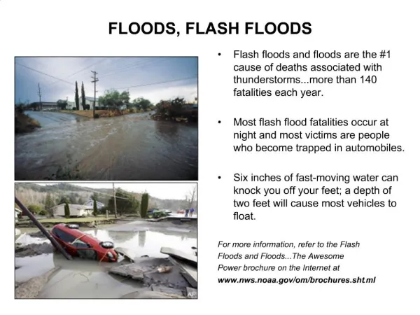
Floods • Floods are the most common and most destructive geologic hazard • Causes of flooding • Naturally occurring • Human-induced factors • Types of floods • Regional floods • Flash floods • Ice-jam floods • Dam failure
Floods • What is a 100-year flood? • It is not a flood that occurs every 100 years • Flood of a given size that has the probability of 1 in 100 of occurring in that year • Better term: 1-in-100 chance flood • Urban planning based on FEMA 100-yr floodmaps
Flood Control • Engineering efforts • Artificial levees • Flood-control Dams • Channelization • Nonstructural approach through sound floodplain management • Identify high risk areas • Zoning regulations for development
Flood-Control Dams • Store water for slow release • Lowers crest of flood, spread out over time • Often have other functions • agricultural irrigation water • hydroelectric power • recreation • Reservoir covers previous land use: fertile farmland, historic sites, scenic valleys • Sediment deposition behind dam • Impediment for fish migration
Channelization • Altering a stream channel to speed flow of water to prevent reaching flood height • Clearing channel of debris • Dredging to widen and deepen channel • Lining channel with concrete • Artificial cutoff: straightening the channel • shorter stream increases gradient and velocity of water flow • larger discharge associated with flooding dispersed more quickly • Army Corp of Engineers
Artificial Levees • Earthen mounds on river banks to increase the volume capacity of river • Steeper slopes than natural levees • Trap sediment that otherwise would have been deposited in floodplain • River bed build up often requires raising the height of levee over time • Many artificial levees not built to withstand extreme flooding • Levee failure numberous on Miss. (1993)
Incised Meanders and Stream Terraces • Incised meanders • Meanders in steep, narrow valleys • Caused by a drop in base level or uplift of the region • Stream Terraces • Remnants of a former floodplain • River has adjusted to a relative drop in base level by downcutting • Results in horizontal plane above current floodplain