
ABSTRACT
An enhanced IDEA product with GOES AOD H. Zhang ( hazhang@umbc.edu ) 1 , R. M. Hoff 1 , S.Kondragunta 2 , I. Laszlo 2 , and A. Wimmers 3 1. University of Maryland Baltimore County 2. STAR/NOAA NESDIS 3. University of Wisconsin. ABSTRACT

ABSTRACT
E N D
Presentation Transcript
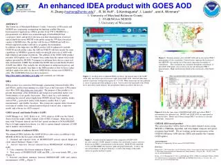
An enhanced IDEA product with GOES AOD H. Zhang (hazhang@umbc.edu)1 , R. M. Hoff1 , S.Kondragunta2 , I. Laszlo2 , and A. Wimmers3 1. University of Maryland Baltimore County 2. STAR/NOAA NESDIS 3. University of Wisconsin ABSTRACT The University of Maryland Baltimore County, University of Wisconsin and NESDIS are cooperating in migrating the Infusing satellite Data into Environmental Applications (IDEA) product from UW to NESDIS for a preoperational test. IDEA was created through a NASA/EPA/NOAA cooperative effort and involves the near-real time dissemination of aerosol optical depth data from MODIS to the public using the UW direct broadcast capture of MODIS data. The product will be run at NESDIS and will be a NOAA supported product relevant to air quality decisionmakers. In addition to the migration, the IDEA product will be enhanced to include GOES-R aerosol product since the ABI on GOES-R will have nearly the same capabilities as MODIS to generate multi-wavelength retrievals of AOD with high temporal and spatial resolutions. The addition of the GOES AOD product provides AOD updates on a 30-minute basis rather than the current twice-daily updates provided by MODIS. To prepare for utilizing these data in a near-real time environment, UMBC has installed the GOES Aerosol and Smoke Product (GASP) into IDEA. This includes the development of additional trajectory and ground-based air quality data links to the IDEA product so that we have a plug-and-play application suite for the new GOES-R data stream once GOES-R in orbit. The GASP IDEA beta test site is located at http://idea.umbc.edu/index_new.php and comments are welcome. Figure 3. National summary plot of GASP AOD and in-situ surface PM2.5 measurement 60-day correlation. Colored circles represent the locations of the AIRNOW sites and the size of the circles represents the number of coincidences. The correlations are calculated through the coincidences of the GASP AOD pixels close to the in-situ site and the hourly PM2.5 measurements. High correlation are found in the eastern part of the United States. Figure. 1. An illustration of enhanced IDEA site shows the national map of the GASP AOD (left) and 48-hr trajectory forecast (right) from GASP AOD. Red and white lines indicate trajectories starting from regions of > 0.4 OD. When trajectories are red, pollution is closer to ground and white pollution is aloft. Vectors show the wind field at the 850mb level, and yellow shade indicates the precipitation which can remove the aerosols. IDEA IDEA product was created in 2003 through a partnership between NASA, EPA and NOAA, and has been running on a daily basis at the University of Wisconsin since May 2004 (http://idea.ssec.wisc.edu). The purpose of this product is to provide knowledge of the distribution and transport of particulate matter over North America to air quality forecasters. This is done via a web interface combining the aerosol optical depth from MODIS aboard Terra satellite, hourly surface PM 2.5 (particulate matter with diameter smaller than 2.5 m) measurements, and wildfire locations. The system also requires direct broadcast receiving of satellite data, regional meteorological forecast data, a trajectory model, and software for AOD retrieval. Figure 4. Sixty-day time-series of MODIS/GASP AOD and surface PM2.5 measurements for individual site. MODIS and GASP AOD are represented as blue and red dots. Hourly and 24-hour average PM2.5 are drawn as solid and dashed lines, respectively. GOES Aerosol and Smoke Product (GASP) GASP (Knapp et al., 2002; Prados et al., 2007) retrieves AOD over the United States from the single visible channel of the GOES-12 imager. Runs near-real time with 30-minute interval and 4x4 km2 spatial resolution at NOAA/NESDIS. Due to its high temporal resolution, it is able to capture diurnal variations of AOD and to monitor aerosol motion. Key components of enhanced IDEA The enhanced IDEA includes the GASP AOD as a data source in addition to the MODIS AOD for the five parts of the IDEA: 1. National and regional views of MODIS/GASP aerosol optical depth and cloud optical thickness (Figure 1 left). 2. Aerosol trajectory forecast initiated from MODIS/GASP AOD(Figure 1 right). 3. 3-day composite data fusion animation (Figure 2). 4. Time series of MODIS/GASP AOD and PM 2.5 for every hourly PM 2.5 site (Figure 4). 5. National correlation summary between MODIS/GASP AOD and surface measurements of PM 2.5 (Figure 3). GOES-R ABI Aerosol product This aerosol product will be derived from multi-channel sensors using MODIS or VIIRS like algorithm, and it has higher temporal and spatial resolution than GASP. We are working on the incorporation of the GOES-R ABI proxy AOD data into IDEA and simulate the 5-minute GOES updates. Figure 2. A frame from the animated 3-day composite of GASP AOD (in color contours), GASP channel 1 radiance (for cloud mask, in gray contours), hourly in-situ PM2.5 concentrations (colored circles), NAM 850 mb wind field vector, and WF-ABBA fire locations (pink and purple diamonds). It shows the aerosol movements in the past three days as well as the change of the winds, surface air quality and fire locations. Acknowledgement This project is supported by NOAA contract DG133E07CN0285. References Knapp, K.R., T.H. Vonder Haar, and Y.J.Kaufman (2002), Aerosol optical depth retrieval from GOES-8: Uncertainty study and retrieval validation over South America, J.Geophys. Res., 107(D7), 4055, doi:10.1029/2001JD00505. Prados, A.I., S. Kondragunta, P. Ciren, and K.R.Knapp (2007), GOES Aerosol/Smoke Product (GASP) over North America: Comparisons to AERONET and MODIS observations, J. Geophys. Res., 112, D15201, doi:10.1029/2006JD007968.


