Download
1 / 33
340 likes | 809 Vues
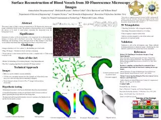
3D Reconstruction Using Aerial Images. A Dense Structure from Motion pipeline. Ramakrishna Vedantam CTT IN, Bangalore. Project Goal. 3D capture of ground structures using aerial imagery. Volume Estimation of mine dumps Infrastructure development monitoring Augmented Reality.

E N D
3D Reconstruction Using Aerial Images A Dense Structure from Motion pipeline Ramakrishna Vedantam CTT IN, Bangalore
Project Goal 3D capture of ground structures using aerial imagery Volume Estimation of mine dumps Infrastructure development monitoring Augmented Reality
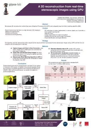
Stereo • 3D information can be ascertained if an object is visible from two views separated by a baseline • This helps us to estimate the depth of the scene
Disparity/ Depth Image Disparity / Depth Image Stereo Input Images
Multi View Stereo (MVS) • Images from multiple views at short baselines used. • Give Better Precision and reduce matching ambiguity • Case for Multi View Stereo • Disparity • baseline, focal length and matching. Camera Model Needed !
Calibration of a Camera Model • Internal parameters • Focal length, pixel aspect ratio etc • External camera parameters • Rotation and Translation in global frame of reference Calibration: finding the internal parameters of the camera
Structure from Motion (SFM) • Findingthe complete 3D object model and complete camera parameters from a collection of images taken from various view-points. • Involves • Stereo Initialization • Triangulation • Bundle Adjustment.
Bundle Adjustment • Stereo Initialization: • Finding relation between features in two initial scenes. • Bundle Adjustment: • Iteratively minimizing reprojection error while adding more cameras and views. Computationally Expensive ! Initialization is Key
SFM: Reconstruction SFM: 2 images SFM: 5 images SFM: 20 images Clearly, not suitable for dense reconstruction.
SFM -> Multi-View Stereo Pipeline SFM Multi-View Stereo Patch based “every pixel” methods used to estimate the disparity/ depth for the whole of a scene. Uses Camera Parameters to give dense depth estimates. • Typically involves matching of sparse features and triangulation of those features. • Generates Camera Parameters. SFM to MVS pipeline gives dense reconstructions !
Accurate, Dense and Robust MVS • Extract features • Get a sparse set of initial matches • Iteratively expand matches to nearby locations • Use visibility constraints to filter out false matches
The Missing Link Where do the Images come from ?
PTAM: Parallel Tracking and Mapping Tracking Stereo Initialization PTAM: Key frame selection Mapping
PTAM • Tracking and mapping are done in parallel allowing more features to be added to map as they are detected. • Bundle Adjustment is done after every few frames. • Enforces a pose change and time heuristic to select key frames.
PTAM -> SFM -> MVS Block Results CUP_60 dataset
PTAM -> SFM -> MVS Block Results Olympic Coke CAN
PTAM -> SFM -> MVS Block Results Olympic Coke CAN + Pen
System Block Diagram – So Far PTAM Bundler PMVS-2 3 stage dense reconstruction pipeline
Volume Estimation • 3D reconstructions stored as point clouds, a set of points in space with color information. • From a point cloud, planar features are segmented out. • Remaining points are clustered. • User views clusters and gives the reference ground truth data and the cluster whose volume is to be estimated.
Volume Estimation • After segmenting the point cloud, the volume is estimated by finding the convex hull of the 3-D point cloud.
Volume Estimation Original Point cloud Clusters
Volume Estimation - Dataset • Ground Truth data : 16.2 cm distance between pens • Height of Cylinder : 12.9 cm • Radius of Cylinder : 2.9 cm • Volume of Cylinder :
Volume Estimation - Dataset • Volume for PTAM dataset: 398.617 cu cm • Image Resolution: 640 x 480 • Accuracy : ground truth is 85.4 % of volume • Number of Images: 102 • Volume for DSLR dataset: 417.69 cu cm • Image Resolution: 1920x1480 • Accuracy : ground truth is 81.4 % of volume • Number of Images: 30
Volume Accuracy • The multi view stereo algorithm gives 98.7% of points 1.25 mm of the reconstruction for reference datasets. • Cameras parameters are noisy, affecting volume accuracy. • Pose information given by the IMU can improve camera parameters. • Clustering done without a-priori shape information, if given, outliers can be filtered out and geometric consistency enforced.
Scope for Improvement • Use sensor data from IMU to estimate camera pose • Make it a real time, live dense reconstruction system • Improve accuracy of volume estimation • Plan the flight of the UAV doing the reconstruction • Making the reconstruction interactive
Related work • Dense Reconstruction on the fly (TU Graz) : • Real time reconstruction • User interaction with live reconstruction • Successfully adapted to UAV • Dense Tracking and Mapping (Imperial College, UK): • Real time dense reconstruction using GPU • Superior Tracking performance, blur resistant • Live dense reconstruction from Monocular Camera (IC) : • Real time monocular dense reconstruction • Sparse Tracking