Download
1 / 2
20 likes | 184 Vues
Precipitation and Latent Heating Estimation using Combined Spaceborne Radar and Microwave Radiometer Data. Duane Waliser Jet Propulsion Laboratory. William Olson, Mircea Grecu, Chung-Lin Shie JCET/UMBC and NASA/GSFC. Tristan L’Ecuyer Colorado State University. Global Latent Heating /

E N D
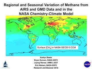
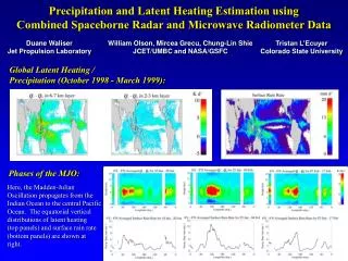
Precipitation and Latent Heating Estimation using Combined Spaceborne Radar and Microwave Radiometer Data Duane Waliser Jet Propulsion Laboratory William Olson, Mircea Grecu, Chung-Lin Shie JCET/UMBC and NASA/GSFC Tristan L’Ecuyer Colorado State University Global Latent Heating / Precipitation (October 1998 - March 1999): Phases of the MJO: Here, the Madden-Julian Oscillation propagates from the Indian Ocean to the central Pacific Ocean. The equatorial vertical distributions of latent heating (top panels) and surface rain rate (bottom panels) are shown at right.
Simulation/Retrieval Studies of Shallow Convection and Snow blue: 183+/-7 GHz red: 89 GHz radar PIA Mircea Grecu, William Olson, Chung-Lin Shie JCET/UMBC and NASA/GSFC Simulation: Estimation: ACR (94 GHz radar) and MIR (183+/-7 GHz radiometer) observations from the Wakasa Bay field experiment are used to estimate snow contents, below. The estimator fit to the 183+/-7 GHz data is also shown. At right is a high-resolution simulation of lake-effect snow, showing the water contents of snow (bottom panel), simulated cloud radar reflectivity factor at 94 GHz (middle panel) and attenuated reflectivities (top panel), assuming a downward-looking radar. The panels at right show the effects of assumed snow density and radiometer viewing angle on upwelling microwave radiances and radar path-integrated attenuation through a vertical column. These simulations serve as a testbed for combined radar/radiometer estimation methods. Such an application to actual data is shown at far right.