Download
1 / 6
60 likes | 232 Vues
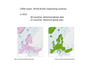
CDDA covers 39 EEA & EEA cooperating countries in 2013 - 30 countries delivered tabular data - 31 countries delivered spatial data. Figure 3: Countries that delivered tabular data. Figure 4: Countries that delivered spatial data.

E N D
CDDA covers 39 EEA & EEA cooperating countries in 2013 - 30 countries delivered tabular data - 31 countries delivered spatial data Figure 3: Countries that delivered tabular data. Figure 4: Countries that delivered spatial data.
95% or records have spatial boundaries 3.7% currently restricted from download
ATF French Southern and Antarctic Lands NOR incl. Svalbard and Jan Mayen Islands Source: cdda table on national overview