Integrating Geo-Standards for Sustainable Data Management and Outreach
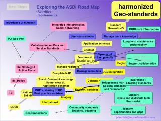
This document outlines the strategic approach to the integration of spatial data standards and user-centric tools to enhance collaboration across jurisdictions. It explores the importance of outreach, the roadmap for adopting best practices, and the synergy of data management as it relates to long-term sustainability. Key activities include developing application schemas, managing registers, and implementing policies that bridge market needs with societal demands. A focus on knowledge management and community standards is essential for addressing environmental variables and fostering a collaborative environment.

Integrating Geo-Standards for Sustainable Data Management and Outreach
E N D
Presentation Transcript
Short term medium term Long term Next Steps • Exploring the ASDI Road Map • Activities • requirements Importance of outreach Integrated Info strategies Social networking Standard Semantic-IO CGDI core infratructure User centric tools Manage more knowledge Put Geo into Long term maintenance sustainability Application schemas Collaboration on Data and Service Standards content Synergy of Best practice Embedding in Jurisdictions Support collaboration Feature cat. IO Spatial ref. syst Registries Manage registers IM- Strategy & Action Plans Manage more data OGC integration Complete NAP Stand. Content & exchange Some- meta d., Application schemas awareness : adopting standards IM- Policy Content- Ontology Bridge mass market Societal demands and “standards” Environ. variables COP’s, sharing of BP, Best practice as driver National Std =N TB Support Create and distribute tools User centric Imagery International CGSB Community standards Enabling, adapting Identify, opportunities and gaps GeoConnections