Download
1 / 4
40 likes | 166 Vues
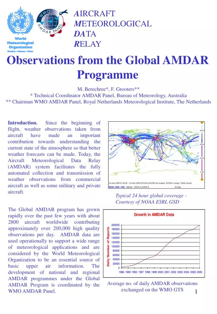
A IRCRAFT M ETEOROLOGICAL DA TA R ELAY. Observations from the Global AMDAR Programme. M. Berechree*, F. Grooters** * Technical Coordinator AMDAR Panel, Bureau of Meteorology, Australia ** Chairman WMO AMDAR Panel, Royal Netherlands Meteorological Institute, The Netherlands.

E N D
AIRCRAFTMETEOROLOGICALDATA RELAY Observations from the Global AMDAR Programme M. Berechree*, F. Grooters*** Technical Coordinator AMDAR Panel, Bureau of Meteorology, Australia** Chairman WMO AMDAR Panel, Royal Netherlands Meteorological Institute, The Netherlands Introduction. Since the beginning of flight, weather observations taken from aircraft have made an important contribution towards understanding the current state of the atmosphere so that better weather forecasts can be made. Today, the Aircraft Meteorological Data Relay (AMDAR) system facilitates the fully automated collection and transmission of weather observations from commercial aircraft as well as some military and private aircraft. Typical 24 hour global coverage - Courtesy of NOAA ESRL GSD The Global AMDAR program has grown rapidly over the past few years with about 2800 aircraft worldwide contributing approximately over 200,000 high quality observations per day. AMDAR data are used operationally to support a wide range of meteorological applications and are considered by the World Meteorological Organization to be an essential source of basic upper air information. The development of national and regional AMDAR programmes under the Global AMDAR Program is coordinated by the WMO AMDAR Panel. Average no. of daily AMDAR observations exchanged on the WMO GTS
Method. Onboard sensors, computers, communications systems supplemented by dedicated AMDAR software collect, process, format and transmit the data to ground stations via satellite, VHF or HF radio links. The transition management is performed via ACARS (Aircraft Communications Addressing and Reporting System) or other aircraft reporting system. Once on the ground, the data is relayed to the global network of National Meteorological Services and other authorized users. The primary data set from each aircraft participating in the Global AMDAR program includes position in time and space, wind speed and direction, and ambient temperature. Some aircraft also provide information on moisture, turbulence and ice accretion. AMDAR data have similar accuracy to radiosonde data and can be used in the same manner. Perhaps one of the most important attributes of the AMDAR data is cost: a typical vertical sounding of temperature and wind derived from an aircraft on ascent or descent produces a profile that is generally less than 1% of the cost of a radiosonde sounding. In addition, in some areas of the world, AMDAR soundings provide the only information available on the detailed vertical structure of the atmosphere. AMDAR data from en-route aircraft are a vital component of the global observing network over oceanic areas normally devoid of in-situ observations. They provide high resolution information that help define certain critical atmospheric phenomena that are not well-resolved by satellite data. Work is proceeding to improve temporal and spatial coverage globally and research will enable additional reported elements to be included in the future. Water vapour content in the atmosphere is one of the most variable and important energy elements needed for forecasting but it is also the least measured and most poorly defined element. Development of an operational water vapour sensor suitable for aircraft use is due to be completed by 2007. Following evaluation trials in the USA and Europe, sensors will be installed on aircraft in the USA, Europe, Australia, New Zealand and South Africa as part of a collaborative program. The AMDAR community is developing collaborative arrangements with the aircraft industry with the aim of standardizing the AMDAR on-board software and the water vapour sensor as customer selectable components for all aircraft types.
Data Quality. AMDAR data quality is high and suitable for use in all operational meteorological applications including the climate record that use radiosonde soundings. The quality of observations obtained from each reporting aircraft is routinely monitored by a number of national, regional and global centres and the information is fed back to airlines that benefit directly by using it to help maintain the high standard of aircraft performance. The NOAA National Centers for Environmental Prediction (NCEP, USA) is the WMO designated lead centre for monitoring aircraft observations. Experience has shown that although there are significant exceptions, the quality of data derived from most large jet transports is high while the quality of similar data derived from many smaller regional and commuter aircraft is often not suitable for meteorological use. Figure 1 displays a typical representation of high quality monthly mean temperature biases during all phases of flight for Canada’s CRJ aircraft while Figure 2 shows the monthly mean temperature bias of all European aircraft that reported in September 2006. Figure 3 shows the current global profile density. Figure 2. Data Quality of European Aircraft – Courtesy: E-AMDAR Programme (bias based on Numerical Model output) Figure 1. Data quality from CRJ passenger aircraft (bias based on Numerical Model output) - Courtesy: Meteorological Service of Canada Targeted Data. In most parts of the world, the AMDAR programme has the capability of being able to target the collection of upper air observations. This provides a significant opportunity for special collaborative programs to be developed between countries operating long haul flights into countries in data sparse regions that are unable to develop local programs of their own. For example, the European AMDAR program has commenced providing AMDAR data for the “Agence pour la Sécurite de la Navigation Aérienne en Afrique et à Madagascar” (ASECNA) group of countries in Central and West Africa using AMDAR equipped long haul aircraft operating from Europe. Figure 3. Typical 24 hour global profile overage - Courtesy of NOAA/ESRL/GSD
Data Impact • Studies show conclusive positive impact of AMDAR data in weather forecast operations. Real time use of high quality vertical profiles of AMDAR data has proven to contribute significantly to the improvement in short to medium-term forecasting applications. However, they are particularly useful for now-casting situations where conditions are changing rapidly and are therefore of special use to the aviation industry. Such applications include: • Surface and upper air forecasts of wind and temperature; • Thunderstorm genesis, location and severity; • Differentiation between rain, snow and freezing rain; • Wind-shear location and intensity e.g. dangerous low-level jets; • Low cloud formation, location and duration; • Fog formation, location and duration; • Turbulence location and intensity; • Jet stream location and intensity; • Environmental control information (trapping inversions etc) Water Vapour profile (in red) - Courtesy of NOAA/ESRL/GSD NCEP has shown that AMDAR data significantly improved numerical weather prediction (NWP) wind forecasts. For example, 3-hour wind forecast error was reduced by 40% with an overall improvement of 11%. 12-hour wind forecasts of winds improved by 5%. One of several significant impacts of these improved wind forecasts is better en-route and terminal management of aircraft with subsequent financial savings gained by the airlines. Improved information pertaining to the location and strength of jet stream cores has also led to improved forecasts of major storm events. Growth. Growth of the Global AMDAR program has been significant over the past two decades. With active support from the WMO AMDAR Panel, AMDAR coverage will continue to improve dramatically as countries with established programs optimize coverage and improve efficiencies. In addition many countries are planning and developing AMDAR programs.