Download
1 / 15
150 likes | 168 Vues
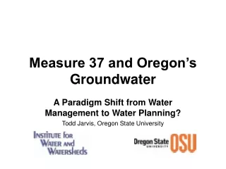
This article explores the paradigm shift in water planning in Oregon, with a focus on the impact of Measure 37 on groundwater management. It discusses the challenges of reconciling water basin planning and land use planning, as well as integrating water quantity and quality regulations. The article also highlights the limited areas with declining water levels in the Willamette Valley and the potential future groundwater problems in certain counties. The importance of developing knowledge and policies for groundwater management is emphasized, including the need for concurrency requirements, public education programs, and groundwater usage fees.

E N D
Measure 37 and Oregon’s Groundwater A Paradigm Shift from Water Management to Water Planning? Todd Jarvis, Oregon State University
Oregon Water & Land Use Laws Never Have Fit Together • “The water basin planning provisions of ORS Chapter 536 have never been reconciled with the land use planning requirements of ORS Chapter 197” • “Regulation of water quantity under ORS 537 has never been integrated with water quality regulation under ORS 468B” Testimony of Gail Achterman on H.B. 2812 – Director, Institute For Natural Resources
15 Groundwater Limited Areas in the Willamette Valley Most focus on the Columbia River Basalt (CRB) Aquifer Water Well Density Map Geologic Map CRB Base maps modified after OWRD and DLCD (2002)
The Existing Situation Amity Hills added in 2003 USGS and OWRD Estimate 100,000 wells in Willamette Valley with 3,000 to 4,000 installed annually Victor Point added in 2001 The bulk of the Groundwater Limited Areas designated in 1992. Victor Point near Silverton added in 2001. Amity Hills/Walnut Hill added in 2003. Base maps modified after OWRD and DLCD (2002). Dates provided courtesy of OWRD.
Groundwater Limited AreasGenerally Based on Water Level Declines Water levels in wells tapping the basalt aquifers have dropped over 60 feet in 40 years in Willamette Valley. Modified after OWRD and DLCD (2002)
Experience Elsewhere in the Western US Reveals Long-Term Production Trends are a Better Planning Metric 200 180 Rated Well Capacity 160 140 120 100 Average Production (GPM) 80 Actual Well Capacity Snowmelt Snowmelt 60 Snowmelt Snowmelt Snowmelt 40 20 0 1992 1993 1994 1995 1996 Data courtesy of Summit Park Water Special Service District, Utah
Permanent Loss of Aquifer Storageis Common in Conduit Flow Aquifers like CRB Modified after Matyjasik, Yonkee and Jarvis (2002)
Measure 37 Claims (2005) may lead to 7,500 to 10,000 New “Exempt” Wells 740(?) Deschutes River Basin Planning (2006) = 12,000 Wells 130 Exempt wells allowed to pump 15,000 gallons per day. 3400 325(?) Bastach (1998) reports State-wide domestic well use at 90 MGD, so M37 wells may potentially double to triple State-wide domestic use. 1280 230 Obvious future potential groundwater problem areas include Yamhill, Washington, and Marion counties. 165 958 370 Groundwater studies in Linn and Benton counties need updating to better predict impacts. Base map modified after OWRD and DLCD (2002).
Wells Are Typically Paired with Septic Systems EOLA HILLS Groundwater Limited Area Dallas Potential new wells and septic systems are being approved within boundaries of Groundwater Limited Areas. Map courtesy of Friends of Polk County (2005). West Salem Monmouth-Independence
The Knowledge Development Challenge in Groundwater Groundwater Economics, Institutions, & Society Hydrogeology Groundwater Flow Modeling Salinity Balance Studies Groundwater Pollution Artificial Recharge Techniques Groundwater Estimation Groundwater Policy & Governance Present State of Knowledge After Mukherji and Shah, 2005 Desired State of Knowledge
Water As Land Use Regulation Modifed after Strachan (2001)
Expect Legal Challenges to Water As Land Use Regulation Rough Water Ahead: Retain Experienced Counsel Modified after Strachan (2001)
Suggested Policies for Intensive Exploitation of Willamette Valley Aquifers • Concurrency requirements for developers, both large and small, based on actual “wet” water, not paper water rights, hydrogeologic studies, or engineering projections. • Public education and information programs using limitation of water availability warranty for homes based on groundwater systems. • Apply a groundwater usage fee or “extraction tax” on all new wells to fund regular well testing, groundwater exploration and/or conjunctive use projects.