Download
1 / 14
140 likes | 216 Vues
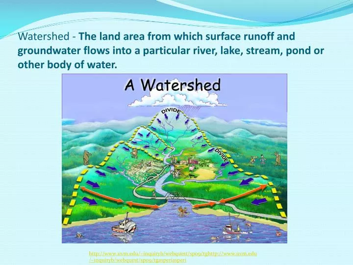
Watershed - The land area from which surface runoff and groundwater flows into a particular river, lake, stream, pond or other body of water. http://www.uvm.edu/~inquiryb/webquest/sp09/tg http://www.uvm.edu/~inquiryb/webquest/sp09/tgasperi asperi.

E N D
Watershed - The land area from which surface runoff and groundwater flows into a particular river, lake, stream, pond or other body of water. http://www.uvm.edu/~inquiryb/webquest/sp09/tghttp://www.uvm.edu/~inquiryb/webquest/sp09/tgasperiasperi
Divide - The point where two watersheds connect, ridge separating two watersheds. (mountain range).Ridge - A line of higher elevation http://www.fairfaxcounty.gov/dpwes/watersheds/whahttp://www.fairfaxcounty.gov/dpwes/watersheds/whatistis
Glacial Till - Unsorted soil composed of silty gravely sand and clay with cobbles and boulders mixed in (think oatmeal raisin cookie). http://pbisotopes.ess.sunysb.edu/reports/dem_2/till-draping.htm
Climate – The average temperature and precipitation a region has over a long period of time http://www.eia.doe.gov/emeu/recs/climate_zone.html
Aquifer - A large underground reservoir of water that can give significant water supplies to wells. http://water.usgs.gov/ogw/gwrp/saltwater/fig5.html
Stream - A body of water with a detectable current, confined within a bed and banks. http://www.garrettcasey.com/pictures/09012003/StreamRock.html
http://tomclarkblog.blogspot.com/2009/06/trout-kill-on-sacramento-river.htmlhttp://tomclarkblog.blogspot.com/2009/06/trout-kill-on-sacramento-river.html http://tomclarkblog.blogspot.com/2009/06/trout-kill-on-sacramento-river.html Headwaters - The place where a river begins (usually a spring). The original point from which the river flows. http://tomclarkblog.blogspot.com/2009/06/trouthttp://tomclarkblog.blogspot.com/2009/06/trout-kill-on-kill-on
River Mouth - The place where a river ends, emptying into the ocean. http://picasaweb.google.com/lh/photo/wUA_hpHhttp://picasaweb.google.com/lh/photo/wUA_hpHZFNte5gWNy2qzMQZFNte5gWNy2qzMQ
Topography - The study of Earth’s land forms http://www.photius.com/countries/hungary/geographttp://www.photius.com/countries/hungary/geographyhy
Contour Line - A line on a map that connects points of equal elevation http://explore.ecb.org/videos/VLC_media?P1=VLC177&REFEREhttp://explore.ecb.org/videos/VLC_media?P1=VLC177&REFERER=OTHERR=OTHER
Contour interval - The distance in elevation between two contour lines http://academic.brookhttp://academic.brooklyn.cuny.edu/geology/levesonlyn.cuny.edu/geology/leveson
Elevation - The height of the land above some point • http://www.yellowmaps.com/map/united-stateselevatihttp://www.yellowmaps.com/map/united-states-elevationon
Slope - The steepness of the land http://www.therockerbox.com/how_to_use_a_map_5.htm http://geology.isu.edu/geostac/Field_Exercise/wildfirehttp
Aspect - The compass direction toward which the land slopes http://www.geo.mtu.edu/volcanoes/fuego/topoair2.html