BEMP: Long-Term Ecological Research & STEM Education Program
10 likes | 109 Vues
The Bosque Ecosystem Monitoring Program (BEMP) engages K-12 students in ecological research to monitor the Rio Grande riparian forest. With over 3000 students yearly and collaboration with various agencies and universities, BEMP promotes environmental stewardship and education through hands-on data collection, field sessions, and teacher workshops.

BEMP: Long-Term Ecological Research & STEM Education Program
E N D
Presentation Transcript
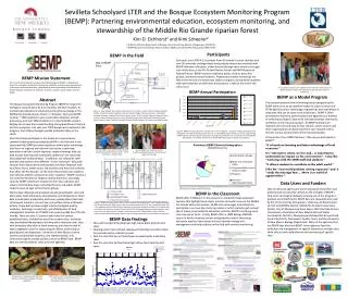
Data Users and Funders Natural resource agency and university based researchers and professionals consistently remark on the strength of BEMP’s long-term and original datasets as being one of the program’s greatest accomplishments. BEMP data are requested and used by the US Army Corps of Engineers, US Bureau of Reclamation, US Fish and Wildlife Service, Middle Rio Grande Conservancy District, City of Albuquerque Open Space, NM Interstate Stream Commission, Association of New Mexico Soil and Water Conservation Districts, Albuquerque Metropolitan Arroyo Flood Control Authority, Stormwater Quality Team, and the University of New Mexico Biology Department. Many of the agencies that use BEMP data also fund BEMP. Some agencies fund the collection and management of specific datasets at multiple sites while others fund establishment and monitoring of specific sites. Map of BEMP Sites Ohkay Owingeh Santo Domingo San Juan Chama Drinking Water Diversion Dam Santa Ana Badger Bobcat Minnow Diversion Calabacillas Alameda Bosque Farms Los Lunas Montaño RGNC Savannah Reynolds forest Rt. 66 Reynolds cleared Valencia cleared BioPark Belen NHCC Valencia forest Harrison Crawford Sevilleta Lemitar Mesilla Valley Kim D. Eichhorst1 and Kimi Scheerer2 = BEMP site 1BEMP Co-Director, Department of Biology, University of New Mexico, Albuquerque, NM 87131 2BEMP Education Coordinator, Bosque School, 4000 Learning Rd. NW, Albuquerque, NM 87120 Participants Each year, over 3000 K-12 students from 45 schools in seven counties and over 60 university undergraduate and graduate interns are involved with BEMP field data collections, either directly through their school or through such institutions as the Rio Grande Nature Center and NM Museum of Natural History. BEMP involves traditional public, charter, parochial, private, and home school students. Preparatory teacher workshops are held in the fall and a seminar-type student congress, during which students make presentations on their sites and projects, is held at the end of the school year. BEMP in the Field . BEMP Mission Statement The mission of the Bosque Ecosystem Monitoring Program (BEMP) is collaborative long-term ecological monitoring of key abiotic and biotic processes and characteristics to promote continued education, understanding, and stewardship of the Middle Rio Grande riparian ecosystem for scientists, teachers, students, policy makers and the public. 7th-12th grade students come together at the end of the school year at a BEMP congress to share their experiences and data after a year of monitoring. Sevilleta Schoolyard LTER and the Bosque Ecosystem Monitoring Program (BEMP): Partnering environmental education, ecosystem monitoring, and stewardship of the Middle Rio Grande riparian forest BEMP as a Model Program The research protocol and monitoring layout designed by the BEMP team serve as an excellent model for citizen science and STEM-based (science, technology, engineering, and mathematics) education that can be done in most locations. BEMP is often presented to teachers, administrators and agencies as a method of collecting ecological data while utilizing volunteer community members on their local landscape. As BEMP materials are relatively low cost and easy to find, schools, nature centers and other organizations can easily start their own research site to monitor various components on their local landscape. In the words of our BEMP teachers, “Why do you participate in BEMP?”… “It is hands on learning and takes advantage of local resources.” It’s “relevant to where we live and… is important to understand our impact on the environment.” I also like “work[ing] with the UNM staff and students.” “It allows students to contribute to the adult world.” I like the “real world problem solving exposure” and it “sends the message that … [there is] a world of opportunities.” Abstract The Bosque Ecosystem Monitoring Program (BEMP) is long-term ecological research done by K-12 students and their teachers to monitor key indicators of structural and functional change in the Middle Rio Grande riparian forest, or “bosque”. Each year BEMP involves ~ 1000 students in year-round data collection and lab processing, and over 2000 students in 1-3 day field/lab sessions, helping to increase their understanding and appreciation of science and the ecosystem. Last year over 7000 people were involved in this program, from OhkayOwingeh pueblo to Mesilla Valley in the south. Over 45 schools participate in the hands-on, inquiry-based, standard linked science provided by BEMP in the field and in the classroom/lab. BEMP provides assistance with teacher workshops that focus on regional and national curriculum, continuing education credit for current teachers, student trainings that can lead to peer teaching and continually updates on-line resources (including field-collected data). In addition, our education staff provides and teaches nine different “in-the-classroom” education sessions that help students and teachers link their fieldwork with local flora, fauna, water issues, lab activities and historical activities that affect the Rio Grande. At the end of the school year, students are invited to attend a symposium-style “congress.” BEMP involves a rich and diverse blend of Hispanic, Native American, and Anglo cultures. BEMP schools are located in inner-city, suburban and urban-rural interface areas, including three local pueblos. BEMP students span all ages and economic groups. Abiotic data collected and analyzed include groundwater, river and ditch water level and quality; precipitation; and temperature. Biotic data include plant productivity and cover; woody debris/fuel load; cottonwood numbers, size and sex; and surface-active arthropod activity. These data provide insight into the biological quality, resilience, hydrologic connectivity, and effectiveness of land management practices of 27 BEMP sites spanning 480 km of the Rio Grande. There are over 15 years of data from the earliest established sites. Included are post-fire recovery sites, wetlands, sites bracketing Albuquerque’s drinking water diversion dam, sites with landscape alteration or bank lowering, and sites cleared of exotic vegetation used for measuring the effects of thinning on groundwater and vegetation. University of New Mexico interns (seniors and graduate students), site representatives, and contracted experts provide quality control on BEMP data. BEMP data are used by federal, state, and local agencies. Figure 4: BEMP annual participation is broken into 7 main categories. Long term includes all students that participate in monthly monitoring, short term are 1-3 day field/education sessions, summer programming, wildlife specific activities, teacher and student trainings, those festivals and community events that BEMP participates in and finally conferences in which BEMP data and/or activities are presented. • Figure 1. Map of BEMP sites along the Rio Grande, from north to south: Pueblo of OhkayOwingeh, Pueblo of Santo Domingo, Pueblo of Santa Ana, Bobcat, Badger, Minnow, Diversion, Calabacillas, Alameda, Montaño, Savannah, Rio Grande Nature Center, Rt. 66, BioPark, National Hispanic Cultural Center, Harrison, Bosque Farms, Los Lunas, Reynolds Forest, Reynolds Cleared, Valencia Cleared, Belen, Valencia Forest, Crawford, Sevilleta National Wildlife Refuge-LTER, Lemitar and Mesilla Valley. At each BEMP site, students collect shallow groundwater aquifer data at 5 wells – north, south, east , west & center. At each BEMP site, students monitor monthly precipitation levels in the open and under heavy canopy. Figure 5: A snapshot of demographics from the 2008-2009 school year illustrates BEMP’s strong commitment to underserved communities. BEMP in the Classroom BEMP offers 9 different ‘in-the-classroom’ standards-linked education sessions that highlight local plants, animals and water issues in the Middle Rio Grande valley (see below). BEMP also encourages local schools to participate in our one-day study trip option in which students get a school day of hiking, environmental education activities, BEMP monitoring and a river-side picnic lunch. Finally, BEMP offers a UNM Biology 408/508 course in which university seniors and graduates and/or continuing education teachers learn about the local riparian ecology and management and help students in the field with monthly monitoring. Figure 2. BEMP sites have similar 100 m x 200 m layouts with roughly north-south lengths paralleling the nearby Rio Grande. Within each of the ten equally spaced units (A-J), are a randomly placed 30m x 5m vegetation plot and litterfall tub. (Vegetation is measured along the southern 30 m transect and fuel load on the northern transect.) There are five PVC shallow groundwater monitoring wells: north, east, south and west wells are each 40 m from the center well. Twenty pitfall traps are used to capture surface-active arthropods. There is one rain gauge under heavy canopy and one in the open. BEMP Data Findings • Sites with overbank flooding have high native plant diversity and cover • Clearing exotic trees without subsequent flooding most often leads to increased exotic understory cover • Post-fire sites that do not flood have increased exotic understory cover • Post-fire sites that do flood have high native plant diversity and cover Students learn about New Mexico watersheds and the impacts of storm events in our StormWater Science classroom session. Students sort native and exotic leaf litter biomass to determine changes in bosque vegetation. Figure 3. Depth to groundwater and river flow below Albuquerque’s San Juan-Chama Drinking Water Project Diversion Dam. Red arrows indicate impacts of construction of the dam and green arrows show impacts of river diversions on depth to groundwater.